File:POL Kozienice old map.jpg
Jump to navigation
Jump to search

Size of this preview: 800 × 569 pixels. Other resolutions: 320 × 228 pixels | 640 × 456 pixels | 1,024 × 729 pixels | 1,291 × 919 pixels.
Original file (1,291 × 919 pixels, file size: 455 KB, MIME type: image/jpeg)
Captions
Captions
Add a one-line explanation of what this file represents
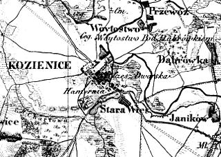
| Description | Kozienice na mapie Topograficznej Królestwa Polskiego 1839, part of map | ||||
| Date | |||||
| Source | Self-scanned | ||||
| Author | Unknown author | ||||
| Permission (Reusing this file) |
|
||||
File history
Click on a date/time to view the file as it appeared at that time.
| Date/Time | Thumbnail | Dimensions | User | Comment | |
|---|---|---|---|---|---|
| current | 16:58, 24 May 2008 | | 1,291 × 919 (455 KB) | Hiuppo (talk | contribs) | {{Information |Description=Kozienice na mapie Topograficznej Królestwa Polskiego 1839, part of map |Source=scan |Date=1839 |Author=unknown |Permission={{PD-old}} |other_versions= }} Category:Kozienice |
You cannot overwrite this file.
File usage on Commons
There are no pages that use this file.
File usage on other wikis
The following other wikis use this file:
- Usage on pl.wikipedia.org