File:PL-MapaDK2.svg
From Wikimedia Commons, the free media repository
Jump to navigation
Jump to search

Size of this PNG preview of this SVG file: 617 × 600 pixels. Other resolutions: 247 × 240 pixels | 494 × 480 pixels | 790 × 768 pixels | 1,053 × 1,024 pixels | 2,107 × 2,048 pixels | 863 × 839 pixels.
Original file (SVG file, nominally 863 × 839 pixels, file size: 555 KB)
File information
Structured data
Captions
Captions
Add a one-line explanation of what this file represents
Summary
[edit]| DescriptionPL-MapaDK2.svg |
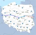
English: Map of route of national road 2 in Poland.
Polski: Mapa przebiegu drogi krajowej nr 2.
|
| Date | |
| Source | Own work |
| Author | Miko101 |
| Permission (Reusing this file) |
This file is licensed under the Creative Commons Attribution-Share Alike 3.0 Unported license.
|
| Other versions | File:Mapa DK2.png |
additional info:
- File:EU-Icon.svg & File:BAB-Grenze.svg done by User:Qualle
- background: File:Poland location map white.svg done by User:Mareklug (license: cc-by-sa-3.0)
File history
Click on a date/time to view the file as it appeared at that time.
| Date/Time | Thumbnail | Dimensions | User | Comment | |
|---|---|---|---|---|---|
| current | 20:25, 2 September 2013 |  | 863 × 839 (555 KB) | Miko101 (talk | contribs) | drobne korekty |
| 13:20, 25 August 2013 |  | 863 × 839 (551 KB) | Miko101 (talk | contribs) | nowy wygląd mapy, dodanie pozostałych dawnych wojewódzkich miast, aktualizacja | |
| 02:38, 7 September 2012 |  | 616 × 581 (508 KB) | Miko101 (talk | contribs) | 1. oddano do użytku obwodnicę Mińska Mazowieckiego<br/> 2. A2 na odcinku Świecko - Rzepin jest bezpłatna | |
| 20:06, 15 June 2012 |  | 616 × 581 (258 KB) | Miko101 (talk | contribs) | 1. autostrada A2 na odcinku Stryków (Łódź) - Warszawa, DK2 teraz od Warszawy do Terespolu 2. opłaty na odcinku A2 Świecko - Nowy Tomyśl 3. nowe węzły w Poznaniu => wydłużenie bezpłatnego odcinka | |
| 18:52, 30 November 2011 |  | 616 × 581 (257 KB) | Miko101 (talk | contribs) | otwarto odcinek autostrady [A2] Świecko-Nowy Tomyśl opłaty od połowy 2012 r. | |
| 20:40, 22 July 2011 |  | 616 × 581 (255 KB) | Miko101 (talk | contribs) | odcinek DK2 w okolicach Warszawy jest dwujezdniowy | |
| 03:51, 18 July 2011 |  | 616 × 581 (253 KB) | Miko101 (talk | contribs) | {{Information |Description ={{en|1=Map of route of national road 2 in Poland. Map legend is available here}} {{pl|1=Mapa przebiegu polskiej [[w:pl:Droga krajowa nr 2 (Polska)|drogi kr |
You cannot overwrite this file.
File usage on Commons
There are no pages that use this file.
File usage on other wikis
The following other wikis use this file:
- Usage on eo.wikipedia.org
- Usage on it.wikipedia.org
- Usage on nl.wikipedia.org
Metadata
This file contains additional information such as Exif metadata which may have been added by the digital camera, scanner, or software program used to create or digitize it. If the file has been modified from its original state, some details such as the timestamp may not fully reflect those of the original file. The timestamp is only as accurate as the clock in the camera, and it may be completely wrong.
| Width | 862.80811 |
|---|---|
| Height | 838.65149 |
Hidden category: