File:PIA21460 - Obstacles and Wakes in Lava.jpg

Original file (2,880 × 1,800 pixels, file size: 947 KB, MIME type: image/jpeg)
Captions
Captions
Summary
[edit]
| Description |
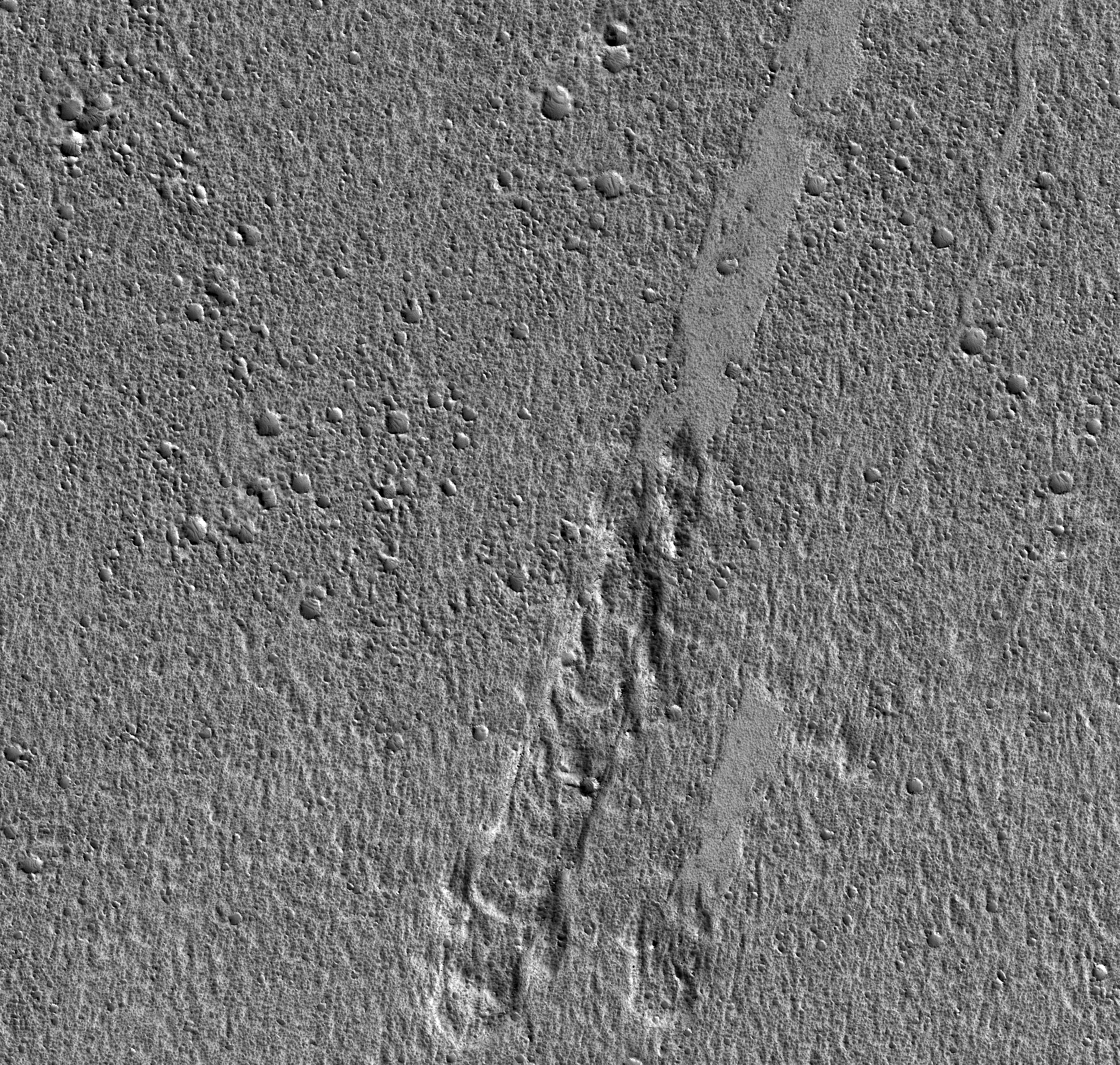
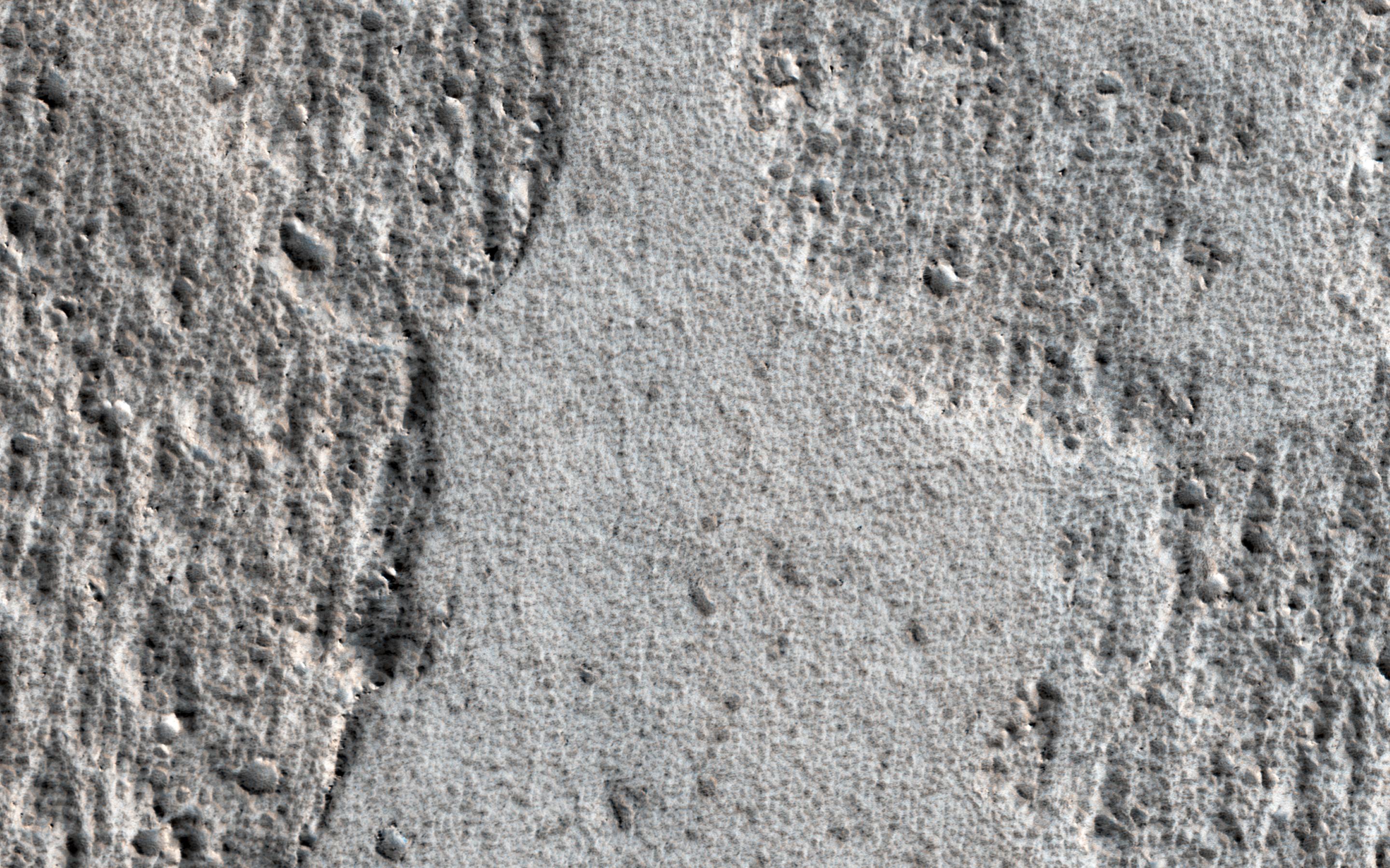
English: Amazonis Planitia is a broad plain on Mars, covered with ancient lava. This image shows an interesting feature of an old lava flow.
When it was mostly liquid, the lava had a crust of cooled debris floating on the surface. Here, the crust just barely scraped over some hills. The flow was able to make it past the hills, but the rubble crust was caught and piled up, forming thick masses of debris. Downstream from the hills, there was no crust left and the lava formed a smoother, fresh surface. Observations like this tell us about the scale of the lava flow (which must have been a huge sheet) and also which direction it was moving at the time when the crust interacted with the hills. The map is projected here at a scale of 50 centimeters (19.7 inches) per pixel. [The original image scale is 59.0 centimeters (23.2 inches) per pixel (with 2 x 2 binning); objects on the order of 177 centimeters (69.7 inches) across are resolved.] North is up. The University of Arizona, Tucson, operates HiRISE, which was built by Ball Aerospace & Technologies Corp., Boulder, Colo. NASA's Jet Propulsion Laboratory, a division of Caltech in Pasadena, California, manages the Mars Reconnaissance Orbiter Project for NASA's Science Mission Directorate, Washington. |
| Date | 19 December 2016 (published 21 February 2016) |
| Source | Catalog page · Full-res (JPEG · TIFF) |
| Author | NASA/JPL-Caltech/Univ. of Arizona |
| Location on Mars | View this and other nearby images on: Google Maps |
|---|
This image or video was catalogued by Jet Propulsion Laboratory of the United States National Aeronautics and Space Administration (NASA) under Photo ID: PIA21460. This tag does not indicate the copyright status of the attached work. A normal copyright tag is still required. See Commons:Licensing. Other languages:
|
 |
This media is a product of the Mars Reconnaissance Orbiter mission Credit and attribution belongs to the High Resolution Imaging Science Experiment (HiRISE) team, NASA/JPL-Caltech/Univ. of Arizona |
Licensing
[edit]
| This file is in the public domain in the United States because it was solely created by NASA. NASA copyright policy states that "NASA material is not protected by copyright unless noted". (See Template:PD-USGov, NASA copyright policy page or JPL Image Use Policy.) | ||
 |
Warnings:
|
File history
Click on a date/time to view the file as it appeared at that time.
| Date/Time | Thumbnail | Dimensions | User | Comment | |
|---|---|---|---|---|---|
| current | 19:33, 21 February 2017 | | 2,880 × 1,800 (947 KB) | PhilipTerryGraham (talk | contribs) | User created page with UploadWizard |
You cannot overwrite this file.
File usage on Commons
The following page uses this file: