File:PIA21267 - Mars Reconnaissance Orbiter Observes Changes.gif

Original file (1,992 × 1,328 pixels, file size: 6.03 MB, MIME type: image/gif, looped, 4 frames, 2.8 s)
Captions
Captions
Summary
[edit]
| Description |
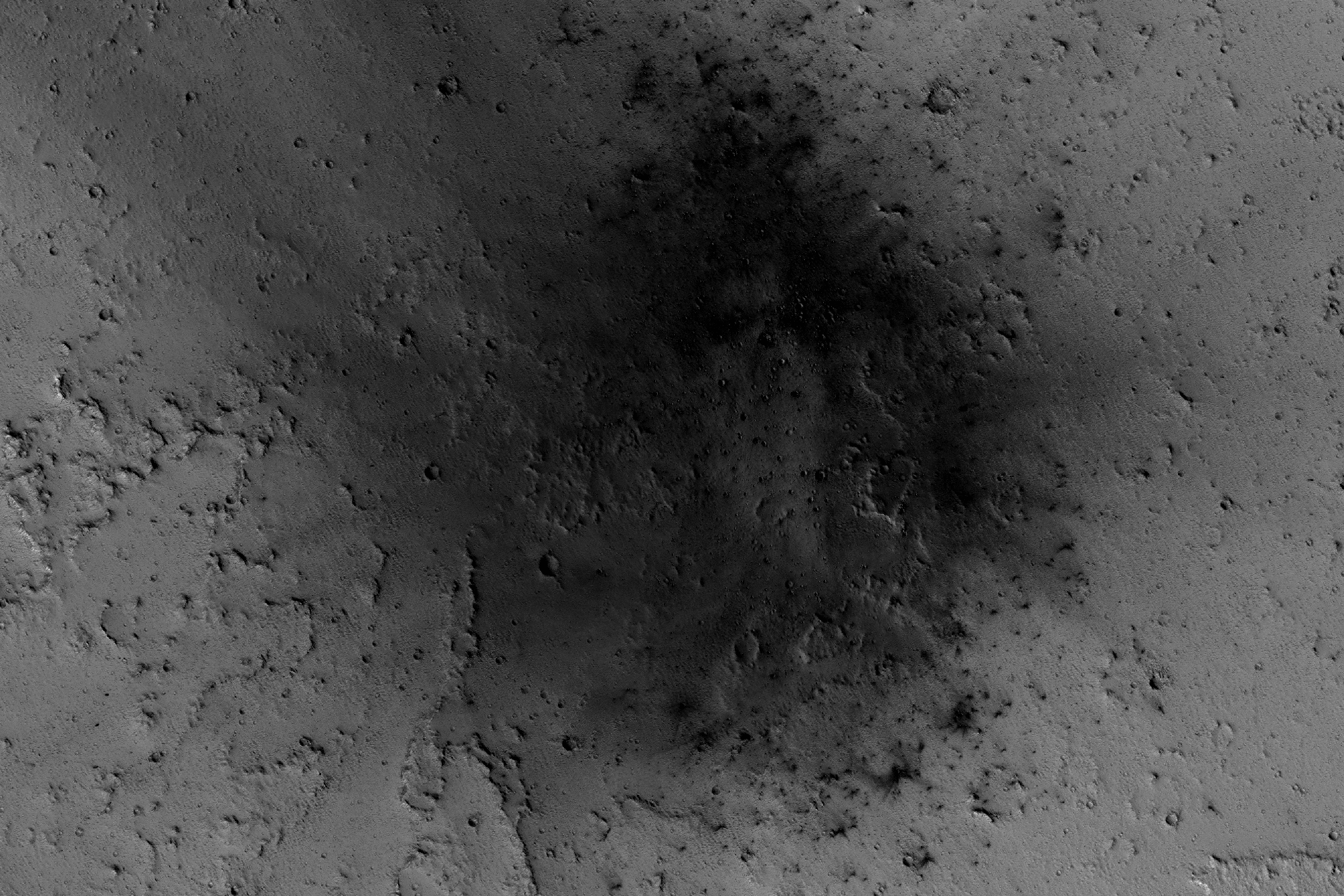
English: NASA's Mars Reconnaissance Orbiter has been observing Mars in sharp detail for more than a decade, enabling it to document many types of changes, such as the way winds alter the appearance of this recent impact site.
The High Resolution Imaging Science Experiment (HiRISE) camera on the orbiter took the four images used in this animated sequence, showing the same site over the time period from March 31, 2007, to April 2, 2012. The earliest of the four observations is the one in which the impact blast zone looks darkest. The space-rock impact that created this blast zone occurred sometime between September 2005 and February 2006, as bracketed by observations made with the Mars Orbiter Camera on NASA's Mars Global Surveyor spacecraft. The location is between two large volcanos, named Ascraeus Mons and Pavonis Mons, in a dusty area of the Tharsis region of Mars. During the period from 2007 to 2012, winds blowing through the pass between the volcanoes darkened some regions and brightened others, probably by removing and depositing dust. The view covers an area about 1.0 mile (1.6 kilometers) across, at 7 degrees north latitude, 248 degrees east longitude. North is toward the top. The images in this four-frame animation are products from HiRISE observations PSP_003172_1870, ESP_007431_1870 (on Feb. 26, 2008), ESP_016160_1870 (on Jan. 6, 2010) and ESP_026643_1870. The University of Arizona, Tucson, operates HiRISE, which was built by Ball Aerospace & Technologies Corp., Boulder, Colorado. NASA's Jet Propulsion Laboratory, a division of Caltech in Pasadena, California, manages the Mars Reconnaissance Orbiter Project for NASA's Science Mission Directorate, Washington. Lockheed Martin Space Systems, Denver, built the orbiter and collaborates with JPL to operate it. |
| Date | 31 March 2007, 26 February 2008, 6 January 2010, 2 April 2012 (published 8 February 2016) |
| Source | Catalog page · Full-res (GIF) |
| Author | NASA/JPL-Caltech/Univ. of Arizona |
| Location on Mars | View this and other nearby images on: Google Maps |
|---|
This image or video was catalogued by Jet Propulsion Laboratory of the United States National Aeronautics and Space Administration (NASA) under Photo ID: PIA21267. This tag does not indicate the copyright status of the attached work. A normal copyright tag is still required. See Commons:Licensing. Other languages:
|
 |
This media is a product of the Mars Reconnaissance Orbiter mission Credit and attribution belongs to the High Resolution Imaging Science Experiment (HiRISE) team, NASA/JPL-Caltech/Univ. of Arizona |
Licensing
[edit]
| This file is in the public domain in the United States because it was solely created by NASA. NASA copyright policy states that "NASA material is not protected by copyright unless noted". (See Template:PD-USGov, NASA copyright policy page or JPL Image Use Policy.) | ||
 |
Warnings:
|
File history
Click on a date/time to view the file as it appeared at that time.
| Date/Time | Thumbnail | Dimensions | User | Comment | |
|---|---|---|---|---|---|
| current | 00:59, 9 February 2017 | | 1,992 × 1,328 (6.03 MB) | PhilipTerryGraham (talk | contribs) | User created page with UploadWizard |
You cannot overwrite this file.
File usage on Commons
The following page uses this file: