File:PIA20032-Pluto-3D-Image-20151023 (cropped).jpg

Original file (1,413 × 1,266 pixels, file size: 1.35 MB, MIME type: image/jpeg)
Captions
Captions
Summary
[edit]| Description |
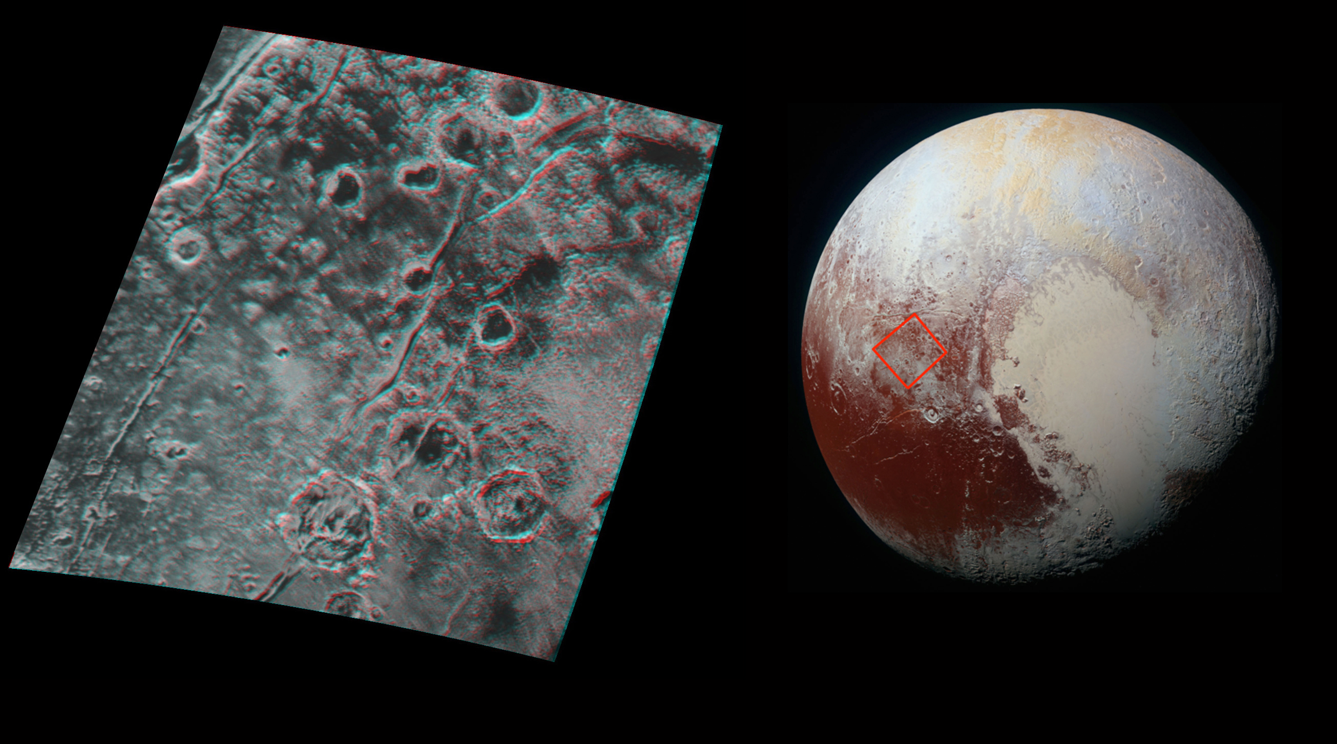
English: PIA20032: Pluto in 3-D - released October 23, 2015
http://photojournal.jpl.nasa.gov/catalog/PIA20032 Global stereo mapping of Pluto's surface is now possible, as images taken from multiple directions are downlinked from NASA's New Horizons spacecraft. Stereo images will eventually provide an accurate topographic map of most of the hemisphere of Pluto seen by New Horizons during the July 14 flyby, which will be key to understanding Pluto's geological history. This example, which requires red/blue stereo glasses for viewing, shows a region 180 miles (300 kilometers) across, centered near longitude 130 E, latitude 20 N (the red square in the global context image). North is to the upper left. The image shows an ancient, heavily cratered region of Pluto, dotted with low hills and cut by deep fractures, which indicate extension of Pluto's crust. Analysis of these stereo images shows that the steep fracture in the upper left of the image is about 1 mile (1.6 kilometers) deep, and the craters in the lower right part of the image are up to 1.3 miles (2.1 km) deep. Smallest visible details are about 0.4 miles (0.6 kilometers) across. The Johns Hopkins University Applied Physics Laboratory in Laurel, Maryland, designed, built, and operates the New Horizons spacecraft, and manages the mission for NASA's Science Mission Directorate. The Southwest Research Institute, based in San Antonio, leads the science team, payload operations and encounter science planning. New Horizons is part of the New Frontiers Program managed by NASA's Marshall Space Flight Center in Huntsville, Alabama. |
| Date | |
| Source | http://photojournal.jpl.nasa.gov/figures/PIA20032_fig1.jpg |
| Author | NASA/Johns Hopkins University Applied Physics Laboratory/Southwest Research Institute |
Licensing
[edit]| This file is in the public domain in the United States because it was solely created by NASA. NASA copyright policy states that "NASA material is not protected by copyright unless noted". (See Template:PD-USGov, NASA copyright policy page or JPL Image Use Policy.) | ||
 |
Warnings:
|

.jpg&action=edit§ion=1)
.jpg&action=edit§ion=2)
File history
Click on a date/time to view the file as it appeared at that time.
| Date/Time | Thumbnail | Dimensions | User | Comment | |
|---|---|---|---|---|---|
| current | 10:09, 14 November 2015 | | 1,413 × 1,266 (1.35 MB) | PlanetUser (talk | contribs) | File:PIA20032-Pluto-3D-Image-20151023.jpg cropped 46 % horizontally and 13 % vertically using CropTool with precise mode. |
You cannot overwrite this file.
File usage on Commons
The following 3 pages use this file:
.jpg&oldid=910705318)