File:PIA17655 Jingpo Lacus crop.jpg
Original file (1,684 × 1,585 pixels, file size: 605 KB, MIME type: image/jpeg)
Captions
Captions
Summary
[edit]
| Description |
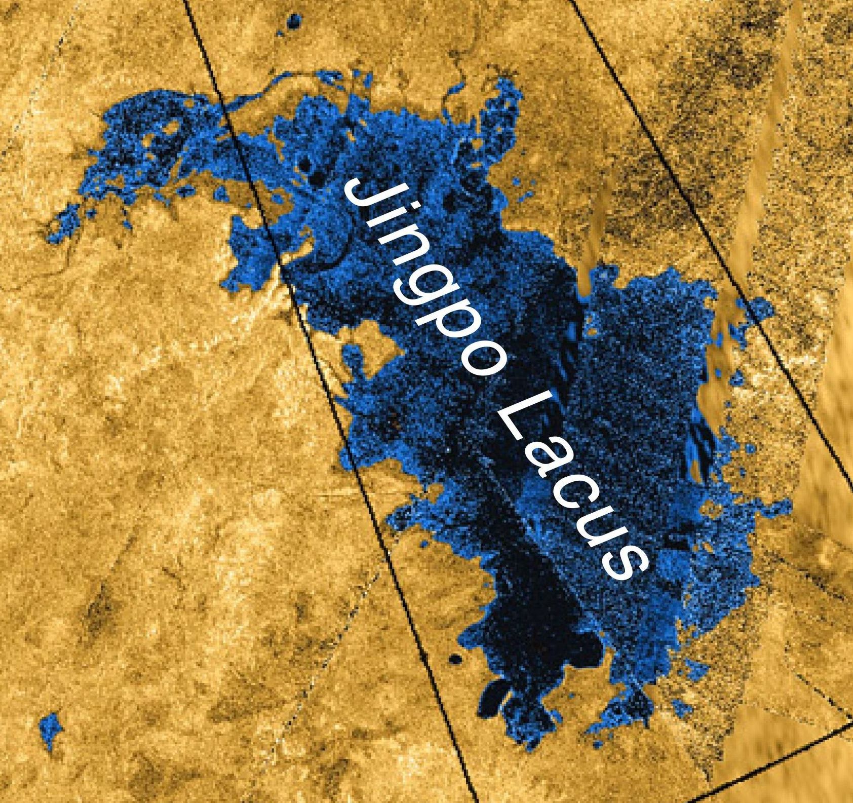
English: This colorized mosaic from NASA's Cassini mission shows the most complete view yet of Titan's northern land of lakes and seas. Saturn's moon Titan is the only world in our solar system other than Earth that has stable liquid on its surface. The liquid in Titan's lakes and seas is mostly methane and ethane.
The data were obtained by Cassini's radar instrument from 2004 to 2013. In this projection, the north pole is at the center. The view extends down to 50 degrees north latitude. In this color scheme, liquids appear blue and black depending on the way the radar bounced off the surface. Land areas appear yellow to white. A haze was added to simulate the Titan atmosphere. Kraken Mare, Titan's largest sea, is the body in black and blue that sprawls from just below and to the right of the north pole down to the bottom right. Ligeia Mare, Titan's second largest sea, is a nearly heart-shaped body to the left and above the north pole. Punga Mare is just below the north pole. The area above and to the left of the north pole is dotted with smaller lakes. Lakes in this area are about 30 miles (50 kilometers) across or less. Most of the bodies of liquid on Titan occur in the northern hemisphere. In fact nearly all the lakes and seas on Titan fall into a box covering about 600 by 1,100 miles (900 by 1,800 kilometers). Only 3 percent of the liquid at Titan falls outside of this area. Scientists are trying to identify the geologic processes that are creating large depressions capable of holding major seas in this limited area. A prime suspect is regional extension of the crust, which on Earth leads to the formation of faults creating alternating basins and roughly parallel mountain ranges. This process has shaped the Basin and Range province of the western United States, and during the period of cooler climate 13,000 years ago much of the present state of Nevada was flooded with Lake Lahontan, which (though smaller) bears a strong resemblance to the region of closely packed seas on Titan. The original NASA image has been cropped to show Jingpo Lacus.Polski: Mapa radarowa Jingpo Lacus - stan wiedzy z 2013 r. Obraz powstał przez przycięcie mozaiki PIA 17655 (zob. File:PIA17655 crop Titan north polar seas and lakes.jpg). |
| Date | |
| Source | http://photojournal.jpl.nasa.gov/catalog/PIA17655 |
| Author | NASA/JPL-Caltech/ASI/USGS |
| Other versions | Image:PIA17655 Jingo Lacus crop2.jpg - Smaller version (1,160 × 780 pixels, 1.05 MB) without label |
Licensing
[edit]
| This file is in the public domain in the United States because it was solely created by NASA. NASA copyright policy states that "NASA material is not protected by copyright unless noted". (See Template:PD-USGov, NASA copyright policy page or JPL Image Use Policy.) | ||
 |
Warnings:
|
File history
Click on a date/time to view the file as it appeared at that time.
| Date/Time | Thumbnail | Dimensions | User | Comment | |
|---|---|---|---|---|---|
| current | 15:20, 31 January 2014 | | 1,684 × 1,585 (605 KB) | Szczureq (talk | contribs) | User created page with UploadWizard |
You cannot overwrite this file.
File usage on Commons
The following page uses this file:
File usage on other wikis
The following other wikis use this file:
- Usage on pl.wikipedia.org