File:PIA11858 Starburst Spider.jpg
Original file (2,560 × 1,920 pixels, file size: 712 KB, MIME type: image/jpeg)
Captions
Captions
Summary
[edit]
| Description |
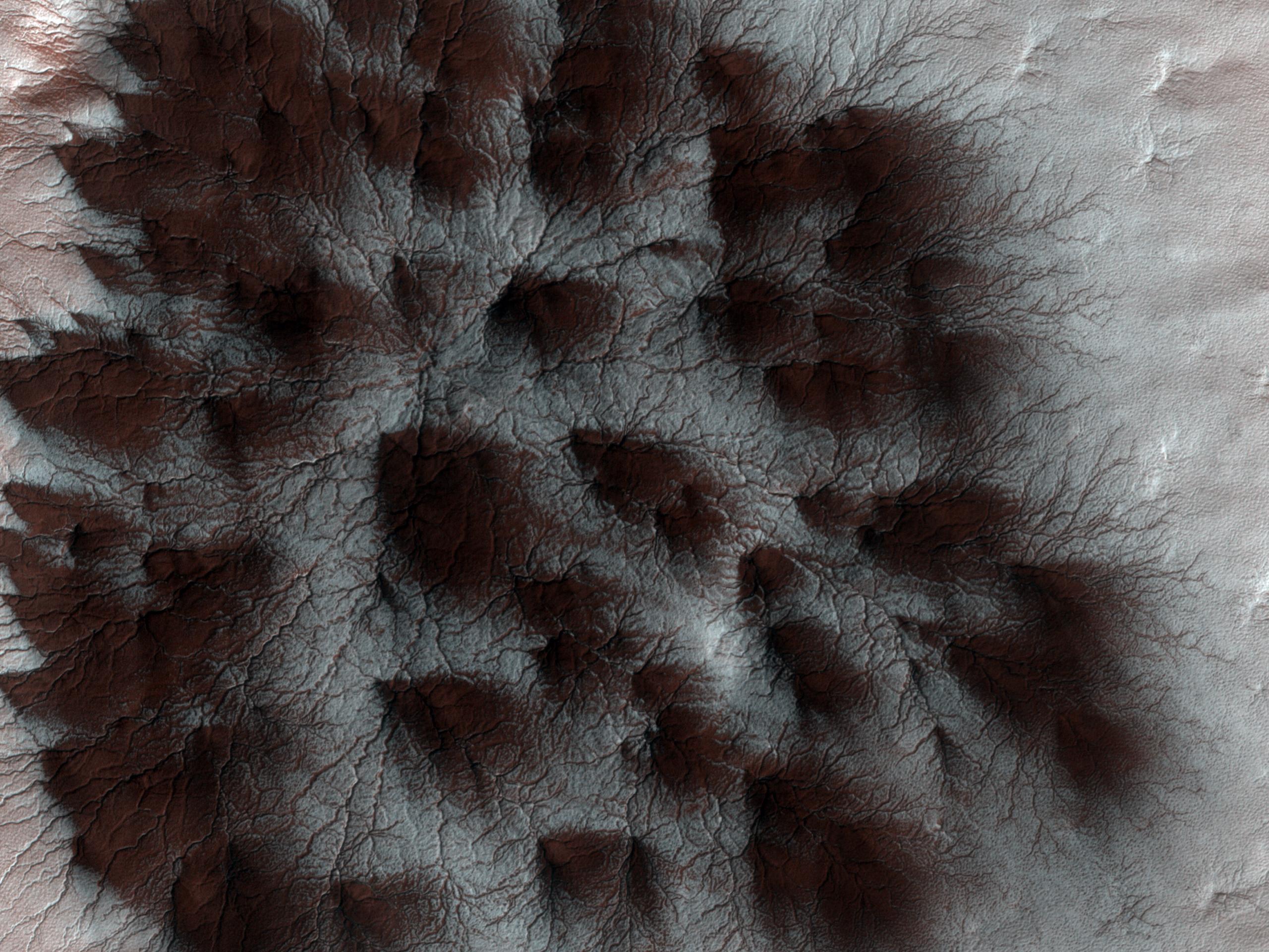
English: Mars' seasonal cap of carbon dioxide ice has eroded many beautiful terrains as it sublimates (goes directly from ice to vapor) every spring. In the region where the High Resolution Imaging Science Experiment (HiRISE) camera on NASA's Mars Reconnaissance Orbiter took this image, we see troughs that form a starburst pattern. In other areas these radial troughs have been refered to as spiders, simply because of their shape. In this region the pattern looks more dendritic as channels branch out numerous times as they get further from the center.
The troughs are believed to be formed by gas flowing beneath the seasonal ice to openings where the gas escapes, carrying along dust from the surface below. The dust falls to the surface of the ice in fan-shaped deposits. This image, covering an area about 1 kilometer (0.6 mile) across, is a portion of the HiRISE observation cataloguedas ESP_011842_0980, taken on Feb. 4, 2009. The observation is centered at 81.8 degrees south latitude, 76.2 degrees east longitude. The image was taken at a local Mars time of 4:56 PM and the scene is illuminated from the west with a solar incidence angle of 78 degrees, thus the sun was about 12 degrees above the horizon. At a solar longitude of 203.6 degrees, the season on Mars is northern autumn. NASA's Jet Propulsion Laboratory, a division of the California Institute of Technology in Pasadena, manages the Mars Reconnaissance Orbiter for NASA's Science Mission Directorate, Washington. Lockheed Martin Space Systems, Denver, is the prime contractor for the project and built the spacecraft. The High Resolution Imaging Science Experiment is operated by the University of Arizona, Tucson, and the instrument was built by Ball Aerospace & Technologies Corp., Boulder, Colo. |
||
| Date | |||
| Source |
http://photojournal.jpl.nasa.gov/catalog/PIA11858
|
||
| Author | NASA/JPL-Caltech/University of Arizona |
Licensing
[edit]
| This file is in the public domain in the United States because it was solely created by NASA. NASA copyright policy states that "NASA material is not protected by copyright unless noted". (See Template:PD-USGov, NASA copyright policy page or JPL Image Use Policy.) | ||
 |
Warnings:
|
File history
Click on a date/time to view the file as it appeared at that time.
| Date/Time | Thumbnail | Dimensions | User | Comment | |
|---|---|---|---|---|---|
| current | 19:13, 30 August 2009 | | 2,560 × 1,920 (712 KB) | WolfmanSF (talk | contribs) | {{Information |Description={{en|1=Mars' seasonal cap of carbon dioxide ice has eroded many beautiful terrains as it sublimates (goes directly from ice to vapor) every spring. In the region where the High Resolution Imaging Science Experiment (HiRISE) came |
You cannot overwrite this file.
File usage on Commons
There are no pages that use this file.
File usage on other wikis
The following other wikis use this file:
- Usage on ca.wikipedia.org
- Usage on ckb.wikipedia.org
- Usage on en.wikipedia.org
- Usage on es.wikipedia.org
- Usage on et.wikipedia.org
- Usage on hr.wikipedia.org
- Usage on it.wikipedia.org
- Usage on pnb.wikipedia.org
- Usage on ro.wikipedia.org
- Usage on uk.wikipedia.org
- Usage on ur.wikipedia.org
- Usage on zh.wikipedia.org