File:PIA02820ITA.png
Jump to navigation
Jump to search

Size of this preview: 800 × 554 pixels. Other resolutions: 320 × 222 pixels | 640 × 443 pixels | 1,024 × 709 pixels | 1,280 × 886 pixels | 2,560 × 1,772 pixels | 4,000 × 2,769 pixels.
Original file (4,000 × 2,769 pixels, file size: 9.75 MB, MIME type: image/png)
Captions
Captions
Add a one-line explanation of what this file represents
Summary
[edit]
| Description |
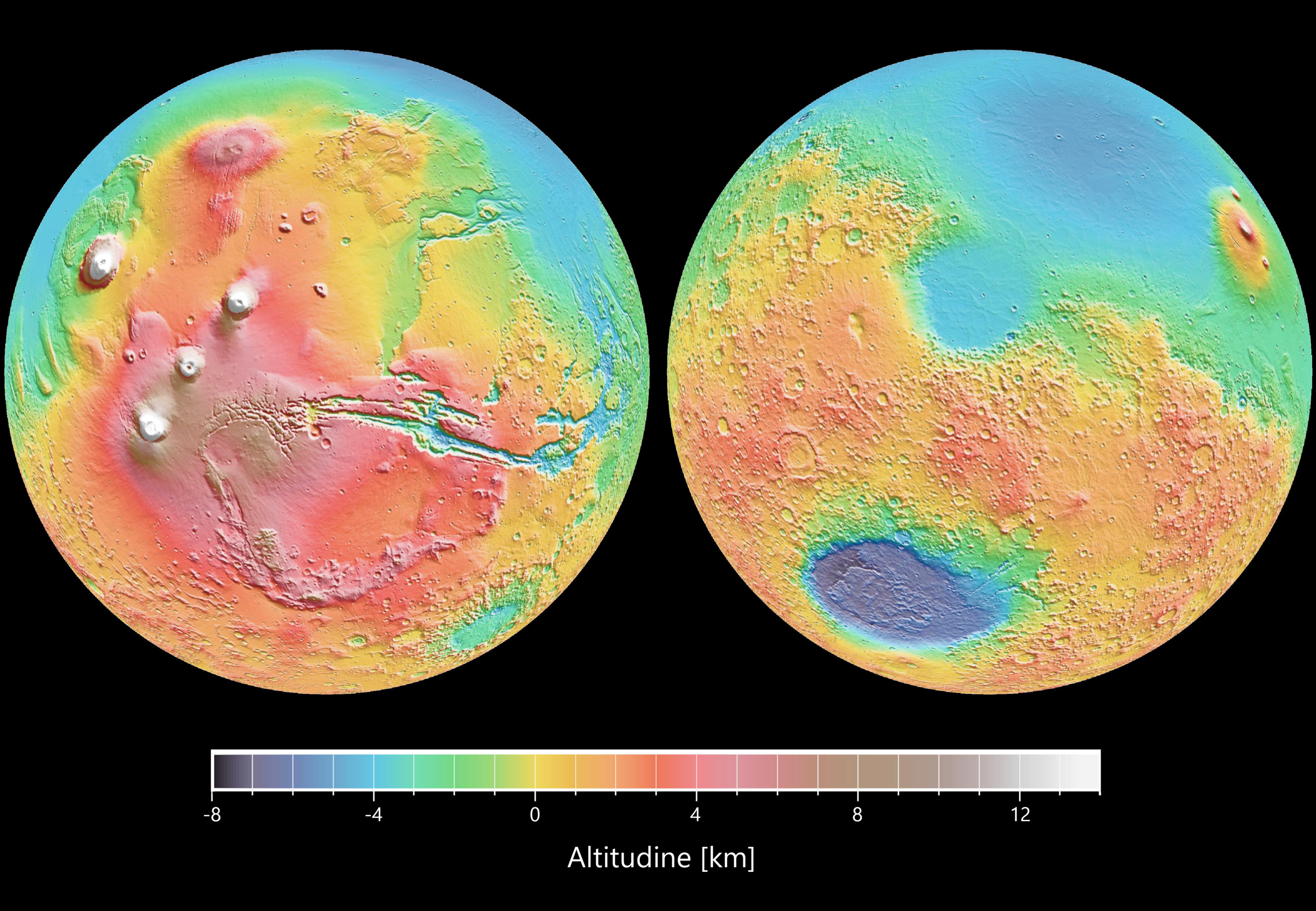
Italiano: Vista topografica in falso colore di Marte a diversi orientamenti ripresa dal Mars Orbiter Laser Altimeter (MOLA). Le proiezioni ortografiche delle mappe contengono oltre 200.000.000 punti e circa 5.000.000 crossover altimetrici. La risoluzione spaziale è di circa 15 chilometri all’equatore e inferiore a latitudini più elevate. La precisione verticale è inferiore a 5 metri. L’immagine di destra mostra il cratere Hellas. L’immagine sinistra mostra il rialzo topografico Tharsis (in rosso e bianco). |
| Date | |
| Source | https://photojournal.jpl.nasa.gov/catalog/PIA02820 |
| Author | NASA/JPL |
Licensing
[edit]
| This file is in the public domain in the United States because it was solely created by NASA. NASA copyright policy states that "NASA material is not protected by copyright unless noted". (See Template:PD-USGov, NASA copyright policy page or JPL Image Use Policy.) | ||
 |
Warnings:
|
File history
Click on a date/time to view the file as it appeared at that time.
| Date/Time | Thumbnail | Dimensions | User | Comment | |
|---|---|---|---|---|---|
| current | 00:28, 15 February 2021 | | 4,000 × 2,769 (9.75 MB) | Sayatek (talk | contribs) | Uploaded a work by NASA/JPL from https://photojournal.jpl.nasa.gov/catalog/PIA02820 with UploadWizard |
You cannot overwrite this file.
File usage on Commons
There are no pages that use this file.
File usage on other wikis
The following other wikis use this file:
- Usage on it.wikipedia.org