File:PEHKO project.png
Jump to navigation
Jump to search

Size of this preview: 800 × 278 pixels. Other resolutions: 320 × 111 pixels | 908 × 315 pixels.
Original file (908 × 315 pixels, file size: 652 KB, MIME type: image/png)
Captions
Captions
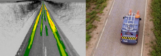
Illustration of output information and road survey vehicle
Summary
[edit]
| Description |
English: LHS - Point Cloud screenshot showing the exact location of deformations on the road surface. RHS - The survey data was collected using a Road Doctor Survey Van equipped with Ground Penetrating Radar (GPR), Laser Scanner, 3D accelerometer and digital video. |
| Date | |
| Source | Own work |
| Author | Roadscanners Oy |
Licensing
[edit]
I, the copyright holder of this work, hereby publish it under the following license:
This file is licensed under the Creative Commons Attribution-Share Alike 4.0 International license.
- You are free:
- to share – to copy, distribute and transmit the work
- to remix – to adapt the work
- Under the following conditions:
- attribution – You must give appropriate credit, provide a link to the license, and indicate if changes were made. You may do so in any reasonable manner, but not in any way that suggests the licensor endorses you or your use.
- share alike – If you remix, transform, or build upon the material, you must distribute your contributions under the same or compatible license as the original.
File history
Click on a date/time to view the file as it appeared at that time.
| Date/Time | Thumbnail | Dimensions | User | Comment | |
|---|---|---|---|---|---|
| current | 11:51, 11 August 2019 | 908 × 315 (652 KB) | Ronmun (talk | contribs) | User created page with UploadWizard |
You cannot overwrite this file.
File usage on Commons
There are no pages that use this file.
File usage on other wikis
The following other wikis use this file:
- Usage on en.wikipedia.org