File:PANO 20170312 131112.jpg
Jump to navigation
Jump to search

Size of this preview: 800 × 202 pixels. Other resolutions: 320 × 81 pixels | 640 × 161 pixels | 1,024 × 258 pixels | 1,280 × 322 pixels | 7,430 × 1,872 pixels.
Original file (7,430 × 1,872 pixels, file size: 2.68 MB, MIME type: image/jpeg)
Captions
Captions
Add a one-line explanation of what this file represents
Summary
[edit]
| Description |
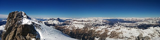
Deutsch: Blick über den Gletscher zum Hauptgipfel der Marmolata (Punta Penia mit Gipfelkreuz) und die Punta Rocca aus östlicher Richtung mit den verschneiten Podesten im Fels. Steile Felswand nach Süden. In der Ferne die Langkofelgruppe bei Canazei. Unten im Tal weiter rechts der Fedaia-Stausee. |
| Date | |
| Source | Own work |
| Author | Federica Carpani |
| Camera location | | View this and other nearby images on: OpenStreetMap |
|---|
sullo sfondo il massiccio del pordoi
Licensing
[edit]
I, the copyright holder of this work, hereby publish it under the following license:
This file is licensed under the Creative Commons Attribution-Share Alike 4.0 International license.
- You are free:
- to share – to copy, distribute and transmit the work
- to remix – to adapt the work
- Under the following conditions:
- attribution – You must give appropriate credit, provide a link to the license, and indicate if changes were made. You may do so in any reasonable manner, but not in any way that suggests the licensor endorses you or your use.
- share alike – If you remix, transform, or build upon the material, you must distribute your contributions under the same or compatible license as the original.
This image was uploaded as part of Wiki Loves Earth 2018.
|
 |
| Annotations | This image is annotated: View the annotations at Commons |
File history
Click on a date/time to view the file as it appeared at that time.
| Date/Time | Thumbnail | Dimensions | User | Comment | |
|---|---|---|---|---|---|
| current | 09:32, 28 June 2018 | 7,430 × 1,872 (2.68 MB) | Carpans (talk | contribs) | User created page with UploadWizard |
You cannot overwrite this file.
File usage on Commons
The following 2 pages use this file:
File usage on other wikis
The following other wikis use this file:
- Usage on de.wikipedia.org