File:P1040510-Kanaga.jpg
From Wikimedia Commons, the free media repository
Jump to navigation
Jump to search
Size of this preview: 800 × 600 pixels. Other resolutions: 320 × 240 pixels | 640 × 480 pixels | 1,024 × 768 pixels | 1,280 × 960 pixels | 2,560 × 1,920 pixels | 3,648 × 2,736 pixels.
Original file (3,648 × 2,736 pixels, file size: 1.51 MB, MIME type: image/jpeg)
File information
Structured data
Captions
Summary
[edit]Camera location | 51° 56′ 45.24″ N, 177° 12′ 32.88″ W | View this and other nearby images on: OpenStreetMap | 51.945900; -177.209133 |
---|
DescriptionP1040510-Kanaga.jpg |
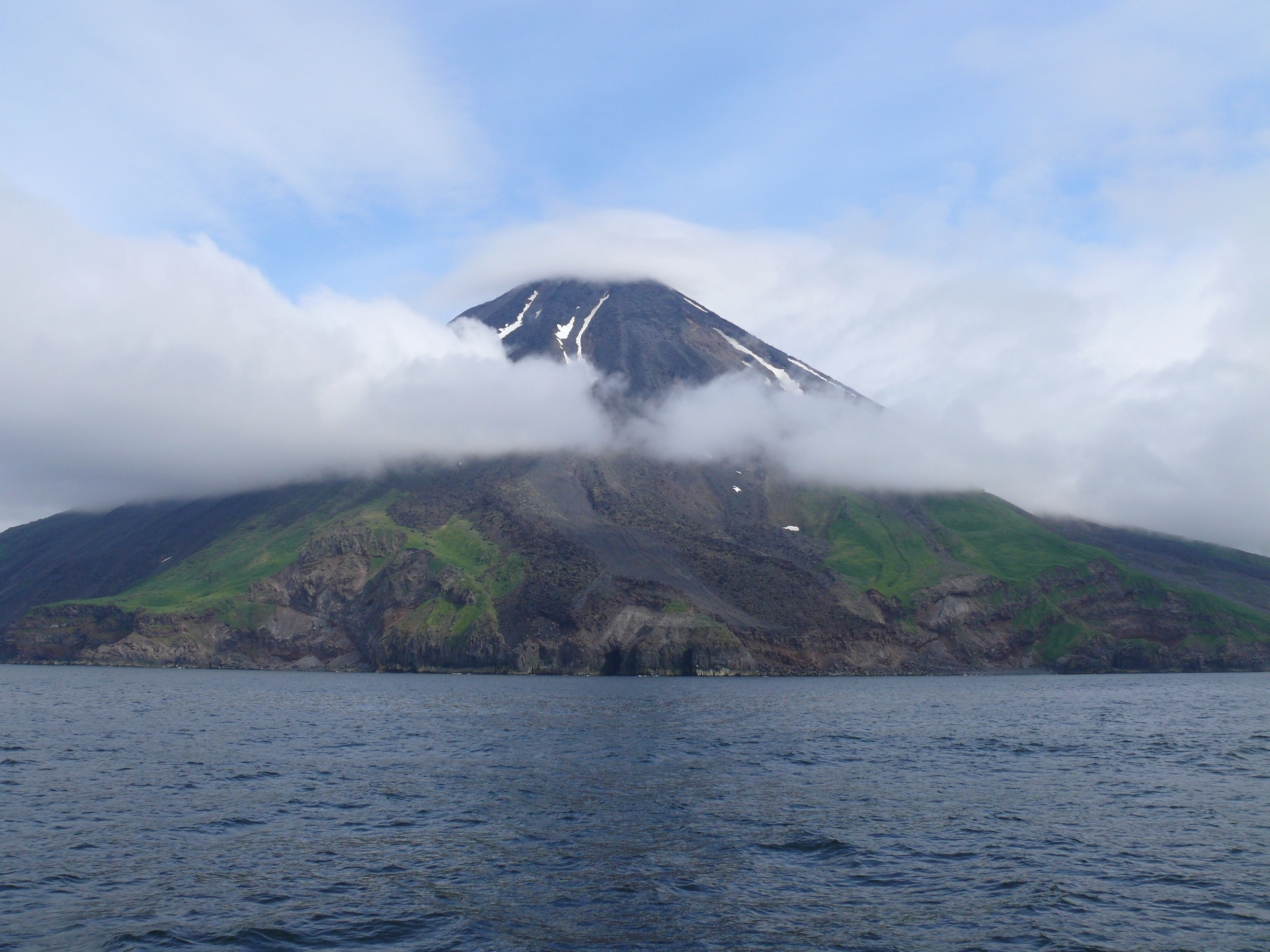
English: 4,288-foot Mount Kanaga on Kanaga Island, Andreanof Islands group of the Aleutian Islands, Alaska. |
Date | |
Source | Own work |
Author | Xpda |
Licensing
[edit]I, the copyright holder of this work, hereby publish it under the following licenses:
Permission is granted to copy, distribute and/or modify this document under the terms of the GNU Free Documentation License, Version 1.2 or any later version published by the Free Software Foundation; with no Invariant Sections, no Front-Cover Texts, and no Back-Cover Texts. A copy of the license is included in the section entitled GNU Free Documentation License.http://www.gnu.org/copyleft/fdl.htmlGFDLGNU Free Documentation Licensetruetrue |
This file is licensed under the Creative Commons Attribution-Share Alike 3.0 Unported license. | ||
| ||
This licensing tag was added to this file as part of the GFDL licensing update.http://creativecommons.org/licenses/by-sa/3.0/CC BY-SA 3.0Creative Commons Attribution-Share Alike 3.0truetrue |
Copyleft: This work of art is free; you can redistribute it and/or modify it according to terms of the Free Art License. You will find a specimen of this license on the Copyleft Attitude site as well as on other sites. http://artlibre.org/licence/lal/enFALFree Art Licensefalsetrue |
You may select the license of your choice.
File history
Click on a date/time to view the file as it appeared at that time.
Date/Time | Thumbnail | Dimensions | User | Comment | |
---|---|---|---|---|---|
current | 21:20, 29 October 2008 | 3,648 × 2,736 (1.51 MB) | Xpda (talk | contribs) | {{Information |Description=4,288-foot Mount Kanaga on Kanaga Island, Andreanof Islands group of the Aleutian Islands, Alaska. |Source=Own work by uploader |Date=July 17, 2008 |Author={{xpda}} |Permission=Original work of the US Federal Government - public |
You cannot overwrite this file.
File usage on Commons
The following page uses this file:
File usage on other wikis
The following other wikis use this file:
- Usage on ca.wikipedia.org
- Usage on fr.wikipedia.org
Metadata
This file contains additional information such as Exif metadata which may have been added by the digital camera, scanner, or software program used to create or digitize it. If the file has been modified from its original state, some details such as the timestamp may not fully reflect those of the original file. The timestamp is only as accurate as the clock in the camera, and it may be completely wrong.
Camera manufacturer | Panasonic |
---|---|
Camera model | DMC-FZ50 |
Exposure time | 1/500 sec (0.002) |
F-number | f/6.3 |
ISO speed rating | 100 |
Date and time of data generation | 03:06, 17 July 2008 |
Lens focal length | 7.4 mm |
Latitude | 51° 56′ 45.24″ N |
Longitude | 177° 12′ 32.88″ W |
Altitude | 14.028 meters above sea level |
Short title | ? |
Location depicted | ? |
Author | ?, ? |
City shown | ? |
Headline | ? |
Credit/Provider | ? |
Source | ? |
Copyright holder | ? |
Image title | ? |
Horizontal resolution | 72 dpi |
Vertical resolution | 72 dpi |
Software used | Photo Mud 3 |
File change date and time | 03:06, 17 July 2008 |
Y and C positioning | Co-sited |
Pair of black and white reference values |
|
Exposure Program | Normal program |
Exif version | 2.2 |
Date and time of digitizing | 03:06, 17 July 2008 |
Meaning of each component |
|
APEX exposure bias | 0 |
Maximum land aperture | 3 APEX (f/2.83) |
Metering mode | Pattern |
Light source | Unknown |
Flash | Flash did not fire, compulsory flash suppression |
Supported Flashpix version | 1 |
Color space | sRGB |
Sensing method | One-chip color area sensor |
File source | Digital still camera |
Scene type | A directly photographed image |
Custom image processing | Custom process |
Exposure mode | Auto exposure |
White balance | Auto white balance |
Digital zoom ratio | 0 |
Focal length in 35 mm film | 35 mm |
Scene capture type | Standard |
Scene control | None |
Contrast | Normal |
Saturation | Normal |
Sharpness | Normal |
GPS time (atomic clock) | 03:07 |
Speed unit | Miles per hour |
Speed of GPS receiver | 0 |
Reference for direction of movement | True direction |
Direction of movement | 0 |
Geodetic survey data used | WGS-84 |
GPS tag version | 0.0.2.2 |
IIM version | 2 |
Editorial status of image | ? |
Urgency | ? |
Category | ? |
Supplemental categories | ? |
Fixture name | ? |
Keywords | ? |
Special instructions | ? |
Time of day that media is intended for | ? |
Sublocation of city shown | ? |
Province or state shown | ? |
Country shown | ? |
Original transmission location code | ? |
Contact information | ? |
Writer | ? |
Language | ? |