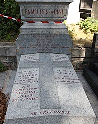
File:Père-Lachaise - Division 5 - Scapini 01.jpg

Original file (3,040 × 3,840 pixels, file size: 6.46 MB, MIME type: image/jpeg)
Captions
Captions
Contents
Summary
Object
| Grave of Georges Scapini
|
||||||||||||||||||||||||
|---|---|---|---|---|---|---|---|---|---|---|---|---|---|---|---|---|---|---|---|---|---|---|---|---|
| Title |
Tomb of Scapini |
|||||||||||||||||||||||
| Object type |
tomb object_type QS:P31,Q381885 |
|||||||||||||||||||||||
| Genre |
funerary art |
|||||||||||||||||||||||
| Description |
Français : Sépulture de Georges Scapini (1893-1976), avocat et homme politique français. Membre durant l'entre-deux-guerres du Comité France-Allemagne, il est ensuite nommé par le gouvernement de Vichy à la tête du Service diplomatique chargé des prisonniers de guerre français en Allemagne. |
|||||||||||||||||||||||
| Collection |
institution QS:P195,Q311 |
|||||||||||||||||||||||
| Current location |
Division 5, chemin Serré, line 2 |
|||||||||||||||||||||||
| Object location |
|
|||||||||||||||||||||||
| Inscriptions |
FAMILLE SCAPINI Georges SCAPINI 4. 10. 1893 25. 3. 1976 Aveugle de guerre - Avocat - Député de Paris - Cmde de la Légion d'Honneur - Ambassadeur Pierre SCAPINI décédé le 31 août 1885 à l'âge de [illegible] ans Jean MINIGGIO décédé le 15 janvier 1891 à l'âge de [illegible] ans Jean Marie Claude CUILLOUD décédé le 31 mars 1894 dans sa 39eme année Laurent SCAPINI décédé le 27 janvier 1899 à l'âge de 31 ans |
|||||||||||||||||||||||
| References |
|
|||||||||||||||||||||||
Photograph
| DescriptionPère-Lachaise - Division 5 - Scapini 01.jpg |
Français : Vue d'ensemble |
| Date | |
| Source | Own work |
| Author | Pierre-Yves Beaudouin |
| Attribution (required by the license) InfoField | Pierre-Yves Beaudouin / Wikimedia Commons / |
InfoField | Pierre-Yves Beaudouin / Wikimedia Commons |
| Object location | 48° 51′ 32.26″ N, 2° 23′ 34.85″ E | View this and other nearby images on: OpenStreetMap |
|---|
Licensing
- You are free:
- to share – to copy, distribute and transmit the work
- to remix – to adapt the work
- Under the following conditions:
- attribution – You must give appropriate credit, provide a link to the license, and indicate if changes were made. You may do so in any reasonable manner, but not in any way that suggests the licensor endorses you or your use.
- share alike – If you remix, transform, or build upon the material, you must distribute your contributions under the same or compatible license as the original.
File history
Click on a date/time to view the file as it appeared at that time.
| Date/Time | Thumbnail | Dimensions | User | Comment | |
|---|---|---|---|---|---|
| current | 03:46, 28 January 2013 |  | 3,040 × 3,840 (6.46 MB) | Slick-o-bot (talk | contribs) | Bot: convert to a non-interlaced jpeg (see bug #17645) |
| 15:48, 29 August 2012 |  | 3,040 × 3,840 (5.71 MB) | ~Pyb (talk | contribs) |
You cannot overwrite this file.
File usage on Commons
The following 4 pages use this file:
File usage on other wikis
The following other wikis use this file:
- Usage on fr.wikipedia.org
- Usage on www.wikidata.org
Metadata
This file contains additional information such as Exif metadata which may have been added by the digital camera, scanner, or software program used to create or digitize it. If the file has been modified from its original state, some details such as the timestamp may not fully reflect those of the original file. The timestamp is only as accurate as the clock in the camera, and it may be completely wrong.
| Camera manufacturer | Canon |
|---|---|
| Camera model | Canon EOS 550D |
| Author | Pierre-Yves Beaudouin |
| Copyright holder | CC-BY-SA |
| Exposure time | 1/200 sec (0.005) |
| F-number | f/4.5 |
| ISO speed rating | 100 |
| Date and time of data generation | 16:40, 28 August 2012 |
| Lens focal length | 18 mm |
| Orientation | Normal |
| Horizontal resolution | 72 dpi |
| Vertical resolution | 72 dpi |
| File change date and time | 11:21, 29 August 2012 |
| Y and C positioning | Co-sited |
| Exposure Program | Aperture priority |
| Exif version | 2.21 |
| Date and time of digitizing | 16:40, 28 August 2012 |
| Meaning of each component |
|
| APEX shutter speed | 7.625 |
| APEX aperture | 4.375 |
| APEX exposure bias | 0.66666666666667 |
| Metering mode | Pattern |
| Flash | Flash did not fire, compulsory flash suppression |
| DateTime subseconds | 61 |
| DateTimeOriginal subseconds | 61 |
| DateTimeDigitized subseconds | 61 |
| Supported Flashpix version | 1 |
| Color space | sRGB |
| Focal plane X resolution | 5,728.1767955801 |
| Focal plane Y resolution | 5,808.4033613445 |
| Focal plane resolution unit | inches |
| Custom image processing | Normal process |
| Exposure mode | Auto exposure |
| White balance | Auto white balance |
| Scene capture type | Standard |
| Image width | 5,184 px |
| Image height | 3,456 px |
Structured data
Items portrayed in this file
depicts
48°51'32.260"N, 2°23'34.854"E
0.005 second
4.5
18 millimetre
100
image/jpeg
- Objects with inscriptions in French needing translation
- Information field template with formatting
- Artworks with SDC link missing
- Artworks with Wikidata item
- Artworks with Wikidata item redundant image
- Files with coordinates missing SDC location of creation (48° N, 2° E)
- CC-BY-SA-3.0
- Self-published work
- Files by User:Pyb
- Taken with Canon EOS 550D
- Taken with Canon EF-S 18-55mm F3.5-5.6 IS

