File:OtoyolMap.svg
Jump to navigation
Jump to search

Size of this PNG preview of this SVG file: 512 × 220 pixels. Other resolutions: 320 × 138 pixels | 640 × 275 pixels | 1,024 × 440 pixels | 1,280 × 550 pixels | 2,560 × 1,100 pixels.
Original file (SVG file, nominally 512 × 220 pixels, file size: 697 KB)
Captions
Captions
Add a one-line explanation of what this file represents
Summary
[edit]
| Description |
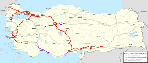
English: Map of Turkish Motorways and Motorway Projects as of 9.1.2016 |
| Date | |
| Source |
Own work using (1), (2) and several documents (ÇED) that are available for the public and can be found at the website of the Turkish Ministry for Environment and Urban Planning (Çevre ve Şehircilik Bakanlığı) This vector image includes elements that have been taken or adapted from this file: |
| Author | Timkili |
Licensing
[edit]
I, the copyright holder of this work, hereby publish it under the following license:
This file is licensed under the Creative Commons Attribution-Share Alike 4.0 International license.
- You are free:
- to share – to copy, distribute and transmit the work
- to remix – to adapt the work
- Under the following conditions:
- attribution – You must give appropriate credit, provide a link to the license, and indicate if changes were made. You may do so in any reasonable manner, but not in any way that suggests the licensor endorses you or your use.
- share alike – If you remix, transform, or build upon the material, you must distribute your contributions under the same or compatible license as the original.
File history
Click on a date/time to view the file as it appeared at that time.
| Date/Time | Thumbnail | Dimensions | User | Comment | |
|---|---|---|---|---|---|
| current | 14:55, 15 February 2022 | | 512 × 220 (697 KB) | Supernovaaa (talk | contribs) | typography changes and update |
| 13:44, 17 March 2017 |  | 1,579 × 677 (1.46 MB) | Timkili (talk | contribs) | O-5 Gemlik-Bursa section opened O-5 İzmir-Kemalpaşa section opened Çanakkale Bridge construction started | |
| 10:41, 4 January 2017 |  | 1,579 × 677 (1.46 MB) | Timkili (talk | contribs) | Tender phase: Ankara-Niğde motorway | |
| 16:43, 14 November 2016 |  | 1,579 × 677 (1.46 MB) | Timkili (talk | contribs) | Tender phase: Menemen-Aliaga-Candarli Motorway | |
| 20:07, 26 October 2016 |  | 1,579 × 677 (1.46 MB) | Timkili (talk | contribs) | Tender phase: Malkara-Canakkale section and Canakkale suspension bridge Remaining sections of Northern Marmara Motorway are under construction now | |
| 11:20, 15 September 2016 |  | 1,579 × 677 (1.46 MB) | Timkili (talk | contribs) | Northern Marmara Motorway, Odayeri-Paşaköy section opened in August 2016 | |
| 22:35, 30 June 2016 |  | 1,579 × 677 (1.46 MB) | Timkili (talk | contribs) | Otoyol 5: Gebze (K1) - Altınova (K2) section (Osman Gazi Bridge) opened on 1 July 2016 | |
| 08:32, 20 April 2016 |  | 1,579 × 677 (1.47 MB) | Timkili (talk | contribs) | Otoyol 5: Altınova (K2) - İznik Güney (K5) section opens on 21 April 2016 | |
| 17:36, 9 January 2016 |  | 1,579 × 677 (1.47 MB) | Timkili (talk | contribs) | User created page with UploadWizard |
You cannot overwrite this file.
File usage on Commons
The following 24 pages use this file:
- User:Chumwa/OgreBot/Potential transport maps/2016 April 11-20
- User:Chumwa/OgreBot/Potential transport maps/2016 June 21-30
- User:Chumwa/OgreBot/Potential transport maps/2016 November 11-20
- User:Chumwa/OgreBot/Potential transport maps/2016 October 21-31
- User:Chumwa/OgreBot/Potential transport maps/2016 September 11-20
- User:Chumwa/OgreBot/Potential transport maps/2017 January 1-10
- User:Chumwa/OgreBot/Potential transport maps/2017 March 11-20
- User:Chumwa/OgreBot/Transport Maps/2016 April 11-20
- User:Chumwa/OgreBot/Transport Maps/2016 January 1-10
- User:Chumwa/OgreBot/Transport Maps/2016 June 21-30
- User:Chumwa/OgreBot/Transport Maps/2016 November 11-20
- User:Chumwa/OgreBot/Transport Maps/2016 October 21-31
- User:Chumwa/OgreBot/Transport Maps/2016 September 11-20
- User:Chumwa/OgreBot/Transport Maps/2017 January 1-10
- User:Chumwa/OgreBot/Transport Maps/2017 March 11-20
- User:Chumwa/OgreBot/Transport Maps/2022 February 10-18
- User:Chumwa/OgreBot/Travel and communication maps/2016 April 11-20
- User:Chumwa/OgreBot/Travel and communication maps/2016 June 21-30
- User:Chumwa/OgreBot/Travel and communication maps/2016 November 11-20
- User:Chumwa/OgreBot/Travel and communication maps/2016 October 21-31
- User:Chumwa/OgreBot/Travel and communication maps/2016 September 11-20
- User:Chumwa/OgreBot/Travel and communication maps/2017 January 1-10
- User:Chumwa/OgreBot/Travel and communication maps/2017 March 11-20
- User:Chumwa/OgreBot/Travel and communication maps/2022 February 10-18
File usage on other wikis
The following other wikis use this file:
- Usage on tr.wikipedia.org