File:Otis Park Golf Club, fairway and Ragsdale House.jpg
Jump to navigation
Jump to search

Size of this preview: 800 × 600 pixels. Other resolutions: 320 × 240 pixels | 640 × 480 pixels | 1,024 × 768 pixels | 1,280 × 960 pixels | 2,560 × 1,920 pixels | 2,816 × 2,112 pixels.
Original file (2,816 × 2,112 pixels, file size: 1.62 MB, MIME type: image/jpeg)
Captions
Captions
Add a one-line explanation of what this file represents
|
This is an image of a place or building that is listed on the National Register of Historic Places in the United States of America. Its reference number is 2001560. |
| Camera location | | View this and other nearby images on: OpenStreetMap |
|---|
| Description |
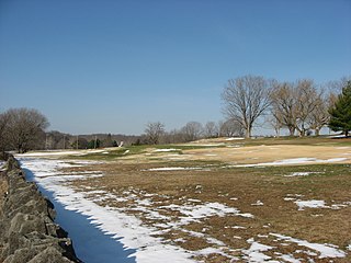
English: A fairway on the Otis Park Golf Club, located along Tunnelton Road on the southeastern edge of Bedford, Indiana, United States. Founded in the early twentieth century, the golf course was expanded by the Works Progress Administration during the Great Depression, and for this reason, it is listed on the National Register of Historic Places. Visible in the distance is the top of the tower of the William A. Ragsdale House, which is separately listed on the Register. |
||
| Date | Taken on 10 December 2010 | ||
| Source | Own work | ||
| Author | Nyttend | ||
| Permission (Reusing this file) |
|
File history
Click on a date/time to view the file as it appeared at that time.
| Date/Time | Thumbnail | Dimensions | User | Comment | |
|---|---|---|---|---|---|
| current | 13:55, 23 December 2010 | | 2,816 × 2,112 (1.62 MB) | Nyttend (talk | contribs) | {{Location|38|51|21.7|N|86|27|17|W}} {{Information |Description={{en|A fairway on the {{w|Otis Park and Golf Course|Otis Park Golf Club}}, located along Tunnelton Road on the southeastern edge of {{w|Bedford, Indiana|Bedford}}, {{w|Indiana}}, {{w|United S |
You cannot overwrite this file.
File usage on Commons
The following page uses this file:
File usage on other wikis
The following other wikis use this file:
- Usage on en.wikipedia.org
- Usage on www.wikidata.org