File:Ostseestraße-2015-02-23.jpg

Original file (1,440 × 868 pixels, file size: 606 KB, MIME type: image/jpeg)
Captions
Captions
Summary
[edit]| Description |
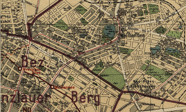
Silva-Übersichtsplan von der Stadt Berlin und ihren 20 Verwaltungsbezirken : auf Grund des Gesetzes vom 27. April 1920 / bearb. und hrsg. von Willy Holz * Format: ca 163 x 117 cm * Orientierung: Nord * Maßstab: 1: 30 000 (Innenstadt 1: 20 000) * 2 Blätter, mehrfarbig |
| Date | (UTC) |
| Source |
This file was derived from: Silva-Übersichtsplan von der Stadt Berlin 1925.jpg: |
| Author |
|
| This is a retouched picture, which means that it has been digitally altered from its original version. Modifications: Die Karte wurde für das Lemma Ostseestraße auf den gewünschten Abschnitt im Bereich zwischen Prenzlauer Allee und Landsberger Chaussee beschnitten. The original can be viewed here: Silva-Übersichtsplan von der Stadt Berlin 1925.jpg:
|
Licensing
[edit]|
This is a faithful photographic reproduction of a two-dimensional, public domain work of art. The work of art itself is in the public domain in its source country for the following reason:
It is also in the public domain in the United States for the following reason:
The official position taken by the Wikimedia Foundation is that "faithful reproductions of two-dimensional public domain works of art are public domain".
This photographic reproduction is therefore also considered to be in the public domain in the United States. In other jurisdictions, re-use of this content may be restricted; see Reuse of PD-Art photographs for details.
|

Original upload log
[edit]
This image is a derivative work of the following images:
- File:Silva-Übersichtsplan_von_der_Stadt_Berlin_1925.jpg licensed with PD-Art-two, PD-EU-no author disclosure
- 2013-02-19T17:46:34Z Alexrk2 19287x13788 (59180364 Bytes) == {{int:description}} == {{InteractiveViewer}} {{Information |Description='''Silva-Übersichtsplan von der Stadt Berlin und ihren 20 Verwaltungsbezirken''' : auf Grund des Gesetzes vom 27. April 1920 / bearb. und hrsg. von W
File history
Click on a date/time to view the file as it appeared at that time.
| Date/Time | Thumbnail | Dimensions | User | Comment | |
|---|---|---|---|---|---|
| current | 13:41, 23 February 2015 | | 1,440 × 868 (606 KB) | Boonekamp (talk | contribs) | {{Information |Description ={{de|1=Ausschnitt des Silva-Plans von 1925 auf die Ostseestraße und deren Verlängerung nach Osten Straße 40a des Plans XIII.}} |Source ={{own}} |Author =Boonekamp |Date = |P... |
You cannot overwrite this file.
File usage on Commons
There are no pages that use this file.
File usage on other wikis
The following other wikis use this file:
- Usage on de.wikipedia.org