File:OstmarkMap.png
Jump to navigation
Jump to search
Size of this preview: 800 × 568 pixels. Other resolutions: 320 × 227 pixels | 640 × 455 pixels | 1,024 × 727 pixels | 1,280 × 909 pixels | 2,360 × 1,676 pixels.
Original file (2,360 × 1,676 pixels, file size: 917 KB, MIME type: image/png)
Captions
Captions
Add a one-line explanation of what this file represents
Summary
[edit]
| Description |
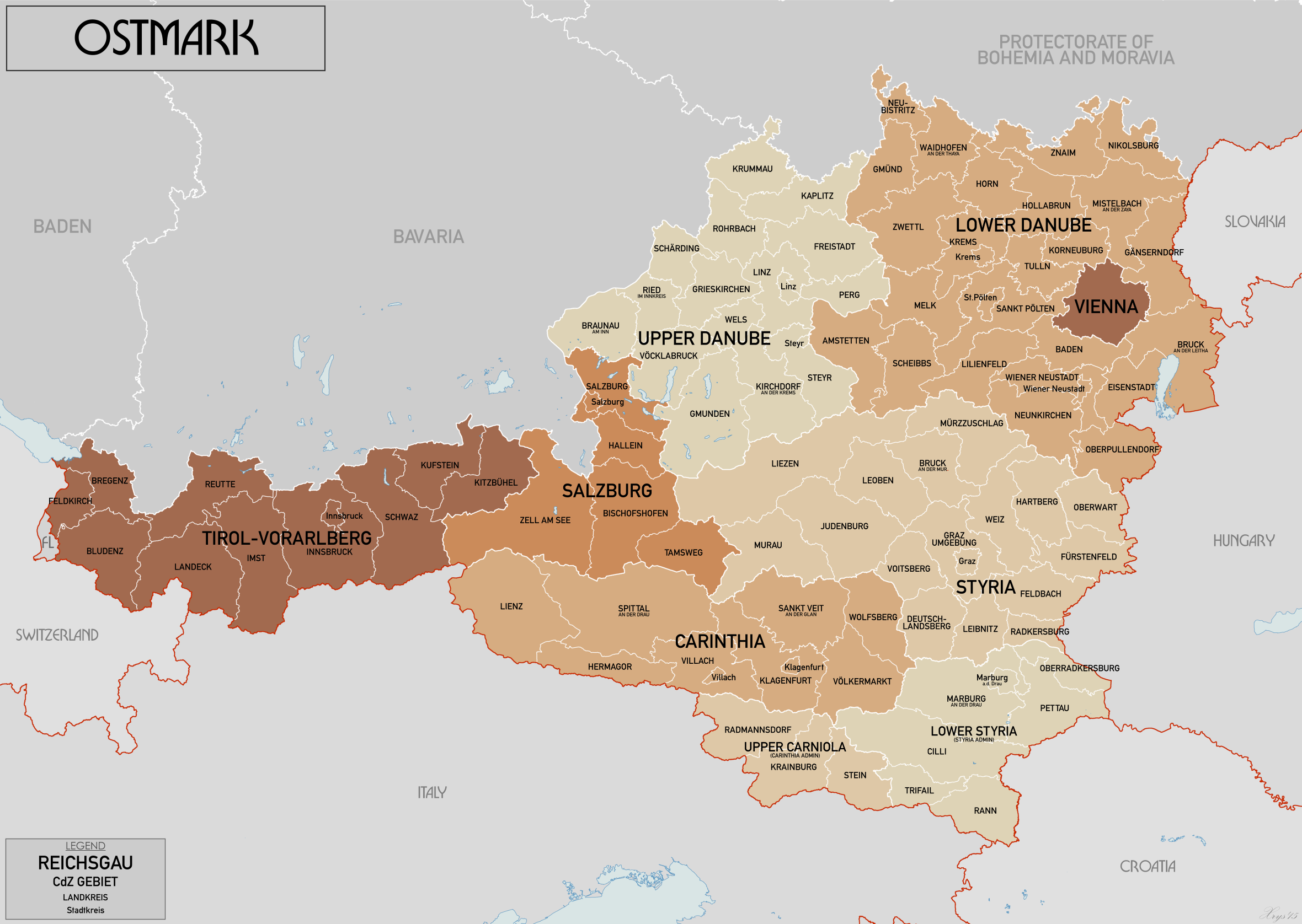
English: Administrative map of Ostmark in 1941. Showing Reichsgaue and CdZ Gebiete subdivided into Landkreise and Stadtkreise. Source map data: Karte von Mitteleuropa 300k, Karte des Deustchen Reiches 100k. Source map site www.mapywig.org. |
| Date | |
| Source | Own work |
| Author | XrysD |
Licensing
[edit]
I, the copyright holder of this work, hereby publish it under the following license:
This file is licensed under the Creative Commons Attribution-Share Alike 4.0 International license.
- You are free:
- to share – to copy, distribute and transmit the work
- to remix – to adapt the work
- Under the following conditions:
- attribution – You must give appropriate credit, provide a link to the license, and indicate if changes were made. You may do so in any reasonable manner, but not in any way that suggests the licensor endorses you or your use.
- share alike – If you remix, transform, or build upon the material, you must distribute your contributions under the same or compatible license as the original.
File history
Click on a date/time to view the file as it appeared at that time.
| Date/Time | Thumbnail | Dimensions | User | Comment | |
|---|---|---|---|---|---|
| current | 14:28, 18 April 2015 | | 2,360 × 1,676 (917 KB) | XrysD (talk | contribs) | Fixed two typos. |
| 19:47, 25 March 2015 |  | 2,360 × 1,676 (917 KB) | XrysD (talk | contribs) | Fixed typos reported by Otberg on German version. | |
| 11:49, 22 March 2015 |  | 2,360 × 1,676 (916 KB) | XrysD (talk | contribs) | Corrected size | |
| 11:42, 22 March 2015 |  | 2,410 × 1,976 (925 KB) | XrysD (talk | contribs) | User created page with UploadWizard |
You cannot overwrite this file.
File usage on Commons
The following 2 pages use this file:
File usage on other wikis
The following other wikis use this file:
- Usage on af.wikipedia.org
- Usage on ar.wikipedia.org
- Usage on ba.wikipedia.org
- Usage on bg.wikipedia.org
- Usage on ca.wikipedia.org
- Usage on en.wikipedia.org
- Usage on es.wikipedia.org
- Usage on fi.wikipedia.org
- Usage on fr.wikipedia.org
- Usage on fr.wiktionary.org
- Usage on he.wikipedia.org
- Usage on id.wikipedia.org
- Usage on ko.wikipedia.org
- Usage on ku.wikipedia.org
- Usage on mk.wikipedia.org
- Usage on ml.wikipedia.org
- Usage on mt.wikipedia.org
- Usage on pt.wikipedia.org
- Usage on sq.wikipedia.org
- Usage on uk.wikipedia.org
- Usage on vi.wikipedia.org
- Usage on www.wikidata.org