File:Osterseen Karte2.png
Jump to navigation
Jump to search

Size of this preview: 355 × 599 pixels. Other resolutions: 142 × 240 pixels | 284 × 480 pixels | 736 × 1,242 pixels.
Original file (736 × 1,242 pixels, file size: 38 KB, MIME type: image/png)
Captions
Captions
Add a one-line explanation of what this file represents
Summary
[edit]
| Description |
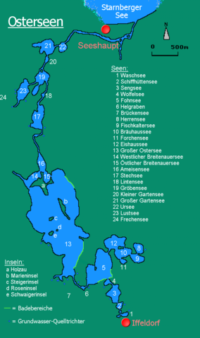
Deutsch: Karte der Osterseen in Oberbayern.
English: Map of the Osterseen, Upper Bavaria, Germany. |
| Date | 31 May 2005 (original upload date) |
| Source | Osterseen Karte.gif: Grundversion selbst erstellt von Dominik Hundhammer |
| Author | Dominik Hundhammer (Bearbeitung durch Ratzer) |
| Permission (Reusing this file) |
GFDL |
| Other versions | copied from de.wikipedia [1] 22:14, 18. Sep. 2006 . . Ratzer . . 736×1242 (38 KB) . . update wegen Rechtschreibfehler (Schiffhüttensee) |
![[1]](https://de.wikipedia.org/wiki/Bild:Osterseen_Karte2.png)
Zerohund at the German-language Wikipedia, the copyright holder of this work, hereby publishes it under the following license:

|
Permission is granted to copy, distribute and/or modify this document under the terms of the GNU Free Documentation License, Version 1.2 or any later version published by the Free Software Foundation; with no Invariant Sections, no Front-Cover Texts, and no Back-Cover Texts. A copy of the license is included in the section entitled GNU Free Documentation License. |
| This file is licensed under the Creative Commons Attribution-Share Alike 3.0 Unported license. | ||
| Attribution: Zerohund | ||
| ||
| This licensing tag was added to this file as part of the GFDL licensing update. |
File history
Click on a date/time to view the file as it appeared at that time.
| Date/Time | Thumbnail | Dimensions | User | Comment | |
|---|---|---|---|---|---|
| current | 21:21, 19 September 2007 | | 736 × 1,242 (38 KB) | Überraschungsbilder (talk | contribs) | {{Information |Description={{de|Karte der Osterseen in Oberbayern.}} {{en|Map of the Osterseen, Upper Bavaria, Germany.}} |Source=Image:Osterseen Karte.gif: Grundversion selbst erstellt von Dominik Hundhammer |Date=2005-05-31 (Ursp |
You cannot overwrite this file.
File usage on Commons
The following page uses this file:
File usage on other wikis
The following other wikis use this file: