File:Ostbelgien2.png

Original file (394 × 788 pixels, file size: 26 KB, MIME type: image/png)
Captions
Captions
| Description |
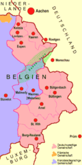
NOTE: This map displays the area of Eupen inaccurately and should therefore not be used. There are two correct new maps: File:Karte Deutschsprachige Gemeinschaft.svg (German-speaking community), File:Karte Ostbelgien.svg (for the three East Cantons) HINWEIS: Diese Karte ist fehlerhaft, da das Eupener Gebiet falsch darstellt wird. Sie sollte entsprechend nicht mehr verwendet werden. Es gibt zwei neue Karten mit korrektem Grenzverlauf: File:Karte Deutschsprachige Gemeinschaft.svg (für die Deutschsprachige Gemeinschaft), File:Karte Ostbelgien.svg (für die drei Ostkantone) Deutsch: Das ab 1815 zum Königreich Preußen, ab 1871 zum Deutschen Reich, seit 1920 zu Belgien gehörige Gebiet, heute drei Kantone, von denen zwei die Deutschsprachigen Gemeinschaft Belgiens bilden, der mittlere zur Französischen Gemeinschaft Belgiens gehört. Versuch, revisionistische Züge der Vorlage zu vermeiden. English: The territory shown belonged to the Kingdom of Prussia from 1815, to the German Reich in 1871, and now belongs to Belgium since 1920. Nowadays, it is divided into three cantons, two of which form the German Community of Belgium, whilst the middle one is part of the Francophone Community of Belgium. |
| Date | |
| Source | Image:Ostbelgien.jpg by User:Wikoli |
| Author | Ulamm |

|
Permission is granted to copy, distribute and/or modify this document under the terms of the GNU Free Documentation License, Version 1.2 or any later version published by the Free Software Foundation; with no Invariant Sections, no Front-Cover Texts, and no Back-Cover Texts. A copy of the license is included in the section entitled GNU Free Documentation License. |
| This file is licensed under the Creative Commons Attribution-Share Alike 3.0 Unported license. | ||
| Attribution: Wikoli | ||
| ||
| This licensing tag was added to this file as part of the GFDL licensing update. |
File history
Click on a date/time to view the file as it appeared at that time.
| Date/Time | Thumbnail | Dimensions | User | Comment | |
|---|---|---|---|---|---|
| current | 12:36, 7 November 2008 | | 394 × 788 (26 KB) | Ulamm (talk | contribs) | {{Information |Description= {{de|Das ab 1815 zum Königreich Preußen, ab 1871 zum Deutschen Reich, seit 1920 zu Belgien gehörige Gebiet, heute drei Kantone, von denen zwei die Deutschsprachigen Gemeinschaft Belgiens bilden, der mittlere zur Französisch |
You cannot overwrite this file.
File usage on Commons
The following page uses this file:
File usage on other wikis
The following other wikis use this file:
- Usage on de.wikipedia.org