File:Oslo kommune byarkivet, oversiktskart 1887 300 hele.jpg
Jump to navigation
Jump to search

Size of this preview: 710 × 599 pixels. Other resolutions: 284 × 240 pixels | 569 × 480 pixels | 910 × 768 pixels | 1,213 × 1,024 pixels | 2,500 × 2,110 pixels.
Original file (2,500 × 2,110 pixels, file size: 6.05 MB, MIME type: image/jpeg)
Captions
Captions
Add a one-line explanation of what this file represents
Summary
[edit]| Title |
Norsk bokmål: Kristiania oppmålingsvesen, 1887. Kart over Kristiania. |
|||||||||||||||||||||||
| Description |
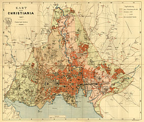
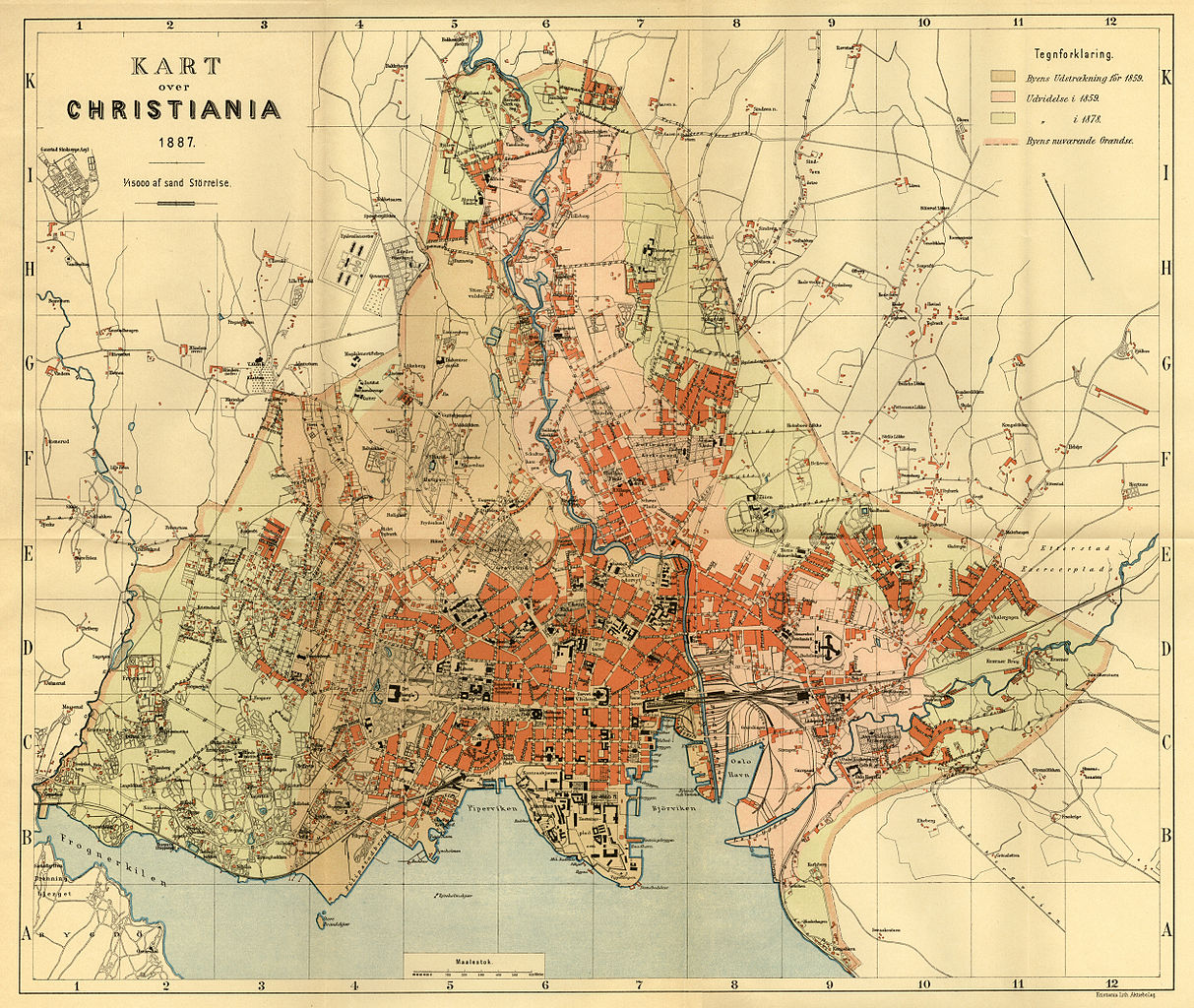
English: Map from 1887 of Christiania. The map shows the city limits before 1859, and the limits as of 1859 and 1878. This was a supplement to the book Femtiaars-Beretning om Christiania Kommune for Aarene 1837-1886, published by the municipality in 1892. See also Oslo kommune byarkivet: Kart fra Kristiania 1887. Norsk bokmål: Kart fra 1887 over Christiania. Kartet viser byens utstrekning før 1859, samt utvidelsene i 1859 og 1878. Dette var bilag til Femtiaars-Beretning om Christiania Kommune for Aarene 1837-1886, som ble utgitt av kommunen i 1892. Se også Oslo kommune byarkivet: Kart fra Kristiania 1887. |
|||||||||||||||||||||||
| Date | ||||||||||||||||||||||||
| Source | http://www.byarkivet.oslo.kommune.no/OBA/Kart/1887/index.html | |||||||||||||||||||||||
| Creator |
Unknown author |
|||||||||||||||||||||||
| Permission (Reusing this file) |
||||||||||||||||||||||||
| Geotemporal data | ||||||||||||||||||||||||
| Date depicted | ||||||||||||||||||||||||
| Scale | 1:15000 | |||||||||||||||||||||||
| Georeferencing | If inappropriate please set warp_status = skip to hide. | |||||||||||||||||||||||
| Bibliographic data | ||||||||||||||||||||||||
| Part of the series | Femtiaars-Beretning om Christiania Kommune for Aarene 1837-1886 (1892) | |||||||||||||||||||||||
| Archival data | ||||||||||||||||||||||||
| Collection |
|
|||||||||||||||||||||||
| Other versions | ||||||||||||||||||||||||

.jpg)
Licensing
[edit]
| This file is in the public domain because legal statutes, administrative regulations, court decisions and other decisions by public authorities are unprotected. This is also the case with proposals, reports and other statements which concern the public exercise of authority, and which are made by a public authority, a publicly appointed council or committee, or published by the public authorities. Similarly, official translations of such texts are unprotected. Intellectual works ("åndsverk" as defined in § 2) which have not been produced specially for use in documents specified in the first paragraph, and from which parts are quoted or which are reproduced in a separate appendix, are not covered by this provision. The same apply to poetry, musical compositions or works of art.
|
 |
File history
Click on a date/time to view the file as it appeared at that time.
| Date/Time | Thumbnail | Dimensions | User | Comment | |
|---|---|---|---|---|---|
| current | 08:39, 16 September 2014 | | 2,500 × 2,110 (6.05 MB) | Jeblad (talk | contribs) | User created page with UploadWizard |
You cannot overwrite this file.
File usage on Commons
The following page uses this file:
File usage on other wikis
The following other wikis use this file:
- Usage on no.wikipedia.org