File:Osięciny (gmina) location map.png
Jump to navigation
Jump to search

Size of this preview: 469 × 600 pixels. Other resolutions: 188 × 240 pixels | 375 × 480 pixels | 758 × 969 pixels.
Original file (758 × 969 pixels, file size: 85 KB, MIME type: image/png)
Captions
Captions
Add a one-line explanation of what this file represents
| Description |
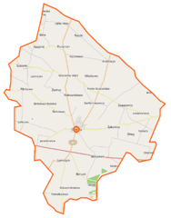
Polski: Mapa gminy Osięciny, Polska
English: Map of Gmina Osięciny, Poland |
|||||||||
| Date | ||||||||||
| Source | You may find a page on the OpenStreetMap wiki page for Osięciny (gmina) | |||||||||
| Creator |
OpenStreetMap contributors OpenStreetMap contributors |
|||||||||
| Permission (Reusing this file) |
OpenStreetMap data is available under the Open Database License (details). Map tiles are licensed under the Creative Commons Attribution-ShareAlike 2.0 license (CC-BY-SA 2.0).
This file is licensed under the Creative Commons Attribution-Share Alike 2.0 Generic license.
|
|||||||||
| Geotemporal data | ||||||||||
| Bounding box |
|
|||||||||
| Georeferencing | If inappropriate please set warp_status = skip to hide. | |||||||||
File history
Click on a date/time to view the file as it appeared at that time.
| Date/Time | Thumbnail | Dimensions | User | Comment | |
|---|---|---|---|---|---|
| current | 10:00, 5 November 2014 | | 758 × 969 (85 KB) | VanWiel (talk | contribs) | {{OpenStreetMap | name = Osięciny (gmina) | location = Osięciny (gmina) | description = {{pl|Mapa gminy Osięciny, Polska}} {{en|Map of Gmina Osięciny, Poland}} | top = 52.7244 | left = 18.6290... |
You cannot overwrite this file.
File usage on Commons
There are no pages that use this file.
File usage on other wikis
The following other wikis use this file:
- Usage on pl.wikipedia.org
- Osięciny (gmina)
- Osięciny
- Bełszewo
- Borucinek
- Lekarzewice
- Leonowo (gmina Osięciny)
- Osłonki
- Pieńki Kościelskie
- Pocierzyn
- Powałkowice
- Samszyce
- Szalonki
- Sęczkowo (województwo kujawsko-pomorskie)
- Ujma Mała
- Wola Skarbkowa
- Zielińsk
- Bartłomiejowice (województwo kujawsko-pomorskie)
- Borucin (województwo kujawsko-pomorskie)
- Kościelna Wieś (województwo kujawsko-pomorskie)
- Nagórki (województwo kujawsko-pomorskie)
- Pilichowo (województwo kujawsko-pomorskie)
- Ruszki (województwo kujawsko-pomorskie)
- Żakowice (województwo kujawsko-pomorskie)
- Bilno (powiat radziejowski)
- Bodzanówek (powiat radziejowski)
- Jarantowice (powiat radziejowski)
- Konary (powiat radziejowski)
- Krotoszyn (powiat radziejowski)
- Latkowo (powiat radziejowski)
- Zagajewice (powiat radziejowski)
- Bełszewo-Kolonia
- Karolin (województwo kujawsko-pomorskie)
- Zblęg
- Pułkownikowo
- Włodzimierka
- Witoldowo (powiat radziejowski)
- Cmentarz żydowski w Osięcinach
- Parafia Opieki Matki Bożej w Osięcinach
- Osięciny (stacja kolejowa)
- Kościół Opieki Matki Bożej w Osięcinach
- Dwór w Borucinku
- Borucin (przystanek kolejowy)
- Borucin-Kolonia
- Moduł:Mapa/dane/Osięciny (gmina)
- Parafia św. Wawrzyńca w Kościelnej Wsi (diecezja włocławska)
- Parafia Najświętszej Maryi Panny Częstochowskiej w Lekarzewicach
- Kościół św. Wawrzyńca w Kościelnej Wsi (diecezja włocławska)
- Osięciny-Probostwo
- Osięciny-Wieś
- Zagaj (województwo kujawsko-pomorskie)
View more global usage of this file.
_location_map.png)
_location_map.png&oldid=519987459)