File:Osetia Południowa.png
Jump to navigation
Jump to search
Size of this preview: 652 × 600 pixels. Other resolutions: 261 × 240 pixels | 522 × 480 pixels | 835 × 768 pixels | 1,113 × 1,024 pixels | 2,227 × 2,048 pixels | 2,681 × 2,466 pixels.
Original file (2,681 × 2,466 pixels, file size: 8.78 MB, MIME type: image/png)
Captions
Captions
Add a one-line explanation of what this file represents
Summary
[edit]
| Description |
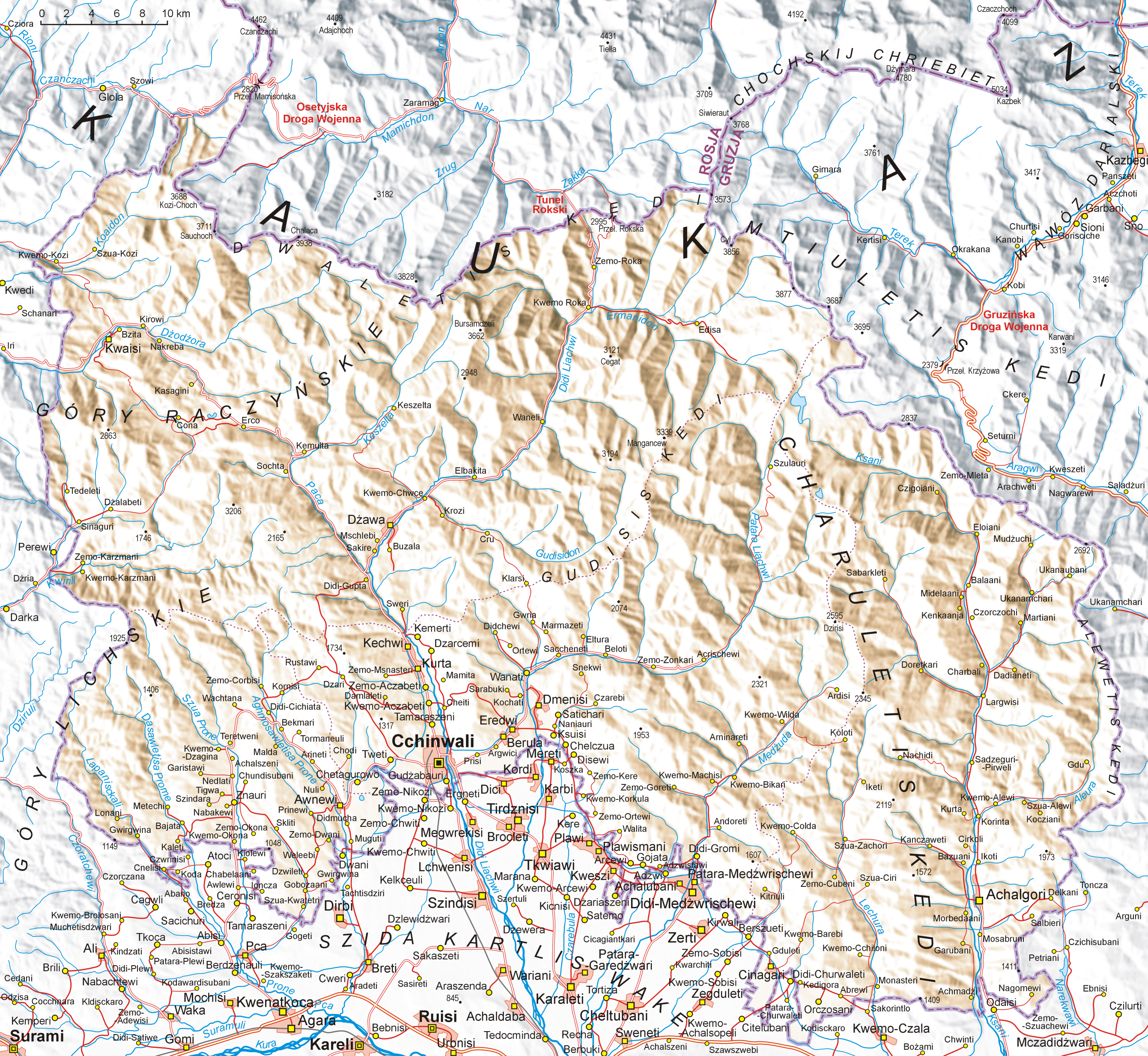
English: Map of South Ossetia, based on Soviet topographic map published in the eighties and Shuttle Radar Topography Mission (STRM). Names are in Polish transcription based on rules of Commission on Standardization of Geographical Names
Outside the Republic of Poland. Differences between Polish transcription and English one: C=TS, CH=KH, CZ=CH, DŻ=J, J=Y, Ł=W, SZ=SH, W=V (i.e.: CCHINWALI=TSKHINVALI, MCZADIDŻWARI=MCHADIJVARI, SZUA-CIRI=SHUA-TSIRI etc.)
Polski: Mapa Osetii Południowej. Mapa opracowana na podstawie radzieckich map topograficznych w skali 1:100 000 z końca lat 80., rzeźba terenu wygenerowana na podstawie danych Shuttle Radar Topography Mission (STRM) udostępnionych przez United States Geological Survey. Nazewnictwo gruzińskie i rosyjskie podane zostało w polskiej transkrypcji fonetycznej zgodnie z tabelami latynizacyjnymi Komisji Standaryzacji Nazw Geograficznych, a polskie egzonimy wg wkazów tejże Komisji. Legenda:  |
| Date | |
| Source | Own work |
| Author | Aotearoa |
| Other versions | Image:Osetia Południowa-strefy.png |
Licensing
[edit]
I, the copyright holder of this work, hereby publish it under the following licenses:

|
Permission is granted to copy, distribute and/or modify this document under the terms of the GNU Free Documentation License, Version 1.2 or any later version published by the Free Software Foundation; with no Invariant Sections, no Front-Cover Texts, and no Back-Cover Texts. A copy of the license is included in the section entitled GNU Free Documentation License. |
| This file is licensed under the Creative Commons Attribution-Share Alike 3.0 Unported license. | ||
| ||
| This licensing tag was added to this file as part of the GFDL licensing update. |
You may select the license of your choice.
File history
Click on a date/time to view the file as it appeared at that time.
| Date/Time | Thumbnail | Dimensions | User | Comment | |
|---|---|---|---|---|---|
| current | 09:46, 17 August 2008 | | 2,681 × 2,466 (8.78 MB) | Aotearoa (talk | contribs) | {{Information |Description= |Source= |Date= |Author= |Permission= |other_versions= }} |
| 20:11, 16 August 2008 |  | 2,681 × 2,466 (8.72 MB) | Aotearoa (talk | contribs) | {{Information |Description={{en|1=Map of South Ossetia}} {{pl|1=Mapa Osetii Południowej}} |Source=Praca własna osoby przesyłającej (own work by uploader) |Author=Aotearoa |Date=16.08.2008 |Permission= |other_versions= }} <!--{{Image |
You cannot overwrite this file.
File usage on Commons
The following page uses this file:
File usage on other wikis
The following other wikis use this file:
- Usage on ar.wikipedia.org
- Usage on bn.wikipedia.org
- Usage on cs.wikipedia.org
- Usage on de.wikipedia.org
- Usage on en.wikipedia.org
- Usage on frr.wikipedia.org
- Usage on fr.wikipedia.org
- Usage on fr.wikinews.org
- Usage on fr.wikivoyage.org
- Usage on it.wikipedia.org
- Usage on krc.wikipedia.org
- Usage on pl.wikipedia.org
- Usage on uk.wikipedia.org