File:OsageTrail Independence Topo 1980red.JPG
Jump to navigation
Jump to search

Size of this preview: 564 × 600 pixels. Other resolutions: 226 × 240 pixels | 452 × 480 pixels | 722 × 768 pixels | 963 × 1,024 pixels | 1,927 × 2,048 pixels | 3,188 × 3,389 pixels.
Original file (3,188 × 3,389 pixels, file size: 3.07 MB, MIME type: image/jpeg)
Captions
Captions
Add a one-line explanation of what this file represents
Summary
[edit]
| Description |
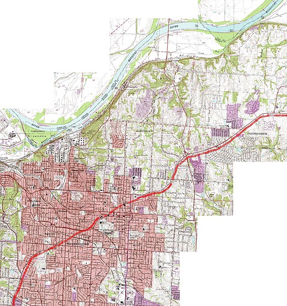
English: Topographical map of much of Independence, Missouri, showing roughly the route of the ancient "Great Osage [Indian] Trail" through the region. The trail originates near central Missouri, Boonville and Franklin, Missouri, followed the route of modern U.S. 24 highway, and portions of modern Lexington Street and Westport Road in Independence, Missouri (the curved portions of each street in modern Independence, Missouri). |
| Date | |
| Source | United States Geological Survey maps (public domain) at "TerraServer USA", USGS in cooperation with Microsoft via msrmaps.com, composite map is from USGS map "Independence, Missouri, United States 7/1/1995" |
| Author | I patch-worked together USGS sectional maps of the region online, such as the segment shown at http://preview.tinyurl.com/339hlmv, and added the blurry red line with MS (Microsoft) "Paint". While the maps are dated "7/1/1995", the data was originally collected and published in 1980. |
The illustration (map) and explanations of it can be revised and enhanced as further research takes place.
Licensing
[edit]
This image is in the public domain in the United States because it only contains materials that originally came from the United States Geological Survey, an agency of the United States Department of the Interior. For more information, see the official USGS copyright policy.
|
File history
Click on a date/time to view the file as it appeared at that time.
| Date/Time | Thumbnail | Dimensions | User | Comment | |
|---|---|---|---|---|---|
| current | 05:52, 7 August 2010 | | 3,188 × 3,389 (3.07 MB) | EGDJ (talk | contribs) | {{Information |Description={{en|1=Topographical map of much of Independence, Missouri, showing roughly the route of the ancient "Great Osage [Indian] Trail" through the region. The trail originates near central Missouri, Boonville and Franklin, Missouri, |
You cannot overwrite this file.
File usage on Commons
There are no pages that use this file.
File usage on other wikis
The following other wikis use this file:
- Usage on en.wikipedia.org