File:Ordnance Survey Drawings - Wick St Lawrence (OSD 47).jpg
Jump to navigation
Jump to search
Size of this preview: 434 × 600 pixels. Other resolutions: 173 × 240 pixels | 347 × 480 pixels | 555 × 768 pixels | 741 × 1,024 pixels | 1,482 × 2,048 pixels | 4,186 × 5,786 pixels.
Original file (4,186 × 5,786 pixels, file size: 2.75 MB, MIME type: image/jpeg)
Captions
Captions
Add a one-line explanation of what this file represents
| Wick St. Lawrence (OSD 47)
|
|||||
|---|---|---|---|---|---|
| Title |
Ordnance Survey Drawings: Wick St Lawrence (OSD 47) |
.jpg) | |||
| Object type |
manuscript map |
||||
| Description |
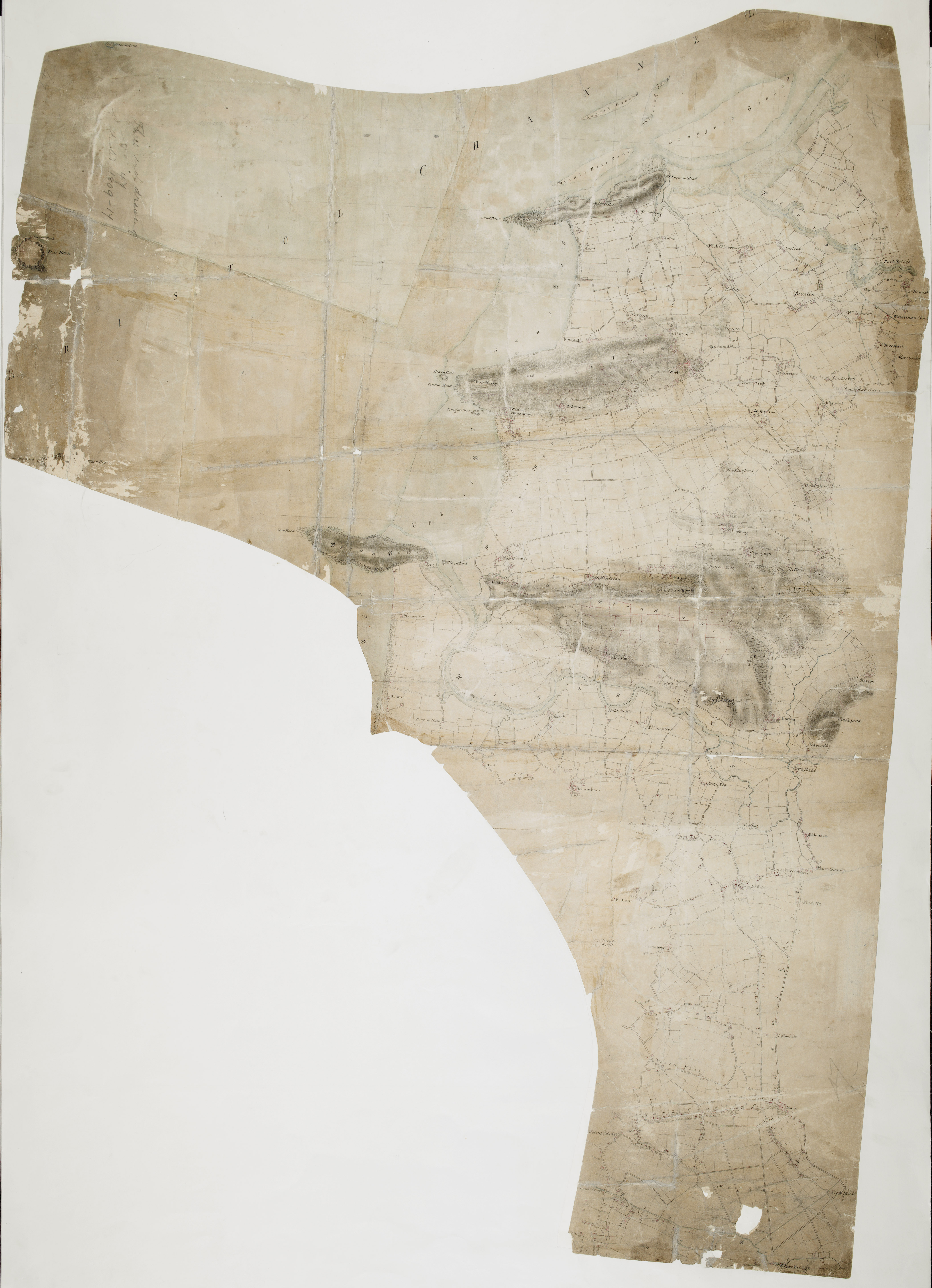
 Centre of map shown on a map of England
English: This drawing covers the area around the mouth of the River Severn, showing sandbanks and the confluence of the River Yeo. Much of the surrounding land is flat with field boundaries marked clearly on the plan. Around Bleadon Hill, red lines describe fields with stone walls. To the right of Newton, a castle is marked by a white circle. The drawing is covered by three-inch squares used for copying and reduction..
This image has been georeferenced.
|
||||
| Language |
English |
||||
| Date | 1809 | ||||
| Medium | Pen and ink on paper | ||||
| Dimensions | height: 510 mm (20.07 in); width: 370 mm (14.56 in) | ||||
| Collection | |||||
| Accession number |
Maps OSD 47 |
||||
| Credit line | British Library | ||||
| Notes |
Scale 3 inches : 1 mile (1:21120). Please note that the British Library provides these digital files "as-is"; materials will not be rephotographed under this programme. If resupply of files is required, the requestor will be required to purchase them at the standard rate. |
||||
| References |
http://www.bl.uk/onlinegallery/onlineex/ordsurvdraw/w/002osd000000017u00342000.html (English) |
||||
| Source/Photographer |
|
||||
| Permission (Reusing this file) |
|
||||


_(St_Edwards_Crown).svg)
.jpg¶ms=51.30911_N_-2.986982_E_)
.jpg¶ms=51.185978_N_-3.129445_E_)
.jpg¶ms=51.432243_N_-2.844518_E_)
.jpg¶ms=51.424376_N_-3.129445_E_)
.jpg¶ms=51.185978_N_-3.110949_E_)
.jpg¶ms=51.193844_N_-2.844518_E_)
.jpg¶ms=51.432243_N_-2.863015_E_)
File history
Click on a date/time to view the file as it appeared at that time.
| Date/Time | Thumbnail | Dimensions | User | Comment | |
|---|---|---|---|---|---|
| current | 21:33, 26 September 2013 | | 4,186 × 5,786 (2.75 MB) | LibraryBot (talk | contribs) | {{subst:User:Andrew Gray/OSD|ID= 002OSD000000017U00342000 |OSD_NUM= OSD 47 |MEDIUM= Pen and ink on paper |TITLE= Wick St Lawrence |CREATOR= |YEAR= 1809 |DESCRIPTION= This drawing covers the area around the mouth of the River Severn, showing sandbanks... |
You cannot overwrite this file.
File usage on Commons
The following page uses this file:
File usage on other wikis
The following other wikis use this file:
- Usage on www.wikidata.org
.jpg&oldid=713427529)