File:Opal 1945 track.png
Jump to navigation
Jump to search

Size of this preview: 756 × 600 pixels. Other resolutions: 303 × 240 pixels | 605 × 480 pixels | 968 × 768 pixels | 1,280 × 1,015 pixels | 2,560 × 2,031 pixels | 2,700 × 2,142 pixels.
Original file (2,700 × 2,142 pixels, file size: 2.04 MB, MIME type: image/png)
Captions
Captions
Add a one-line explanation of what this file represents
Summary
| Description |
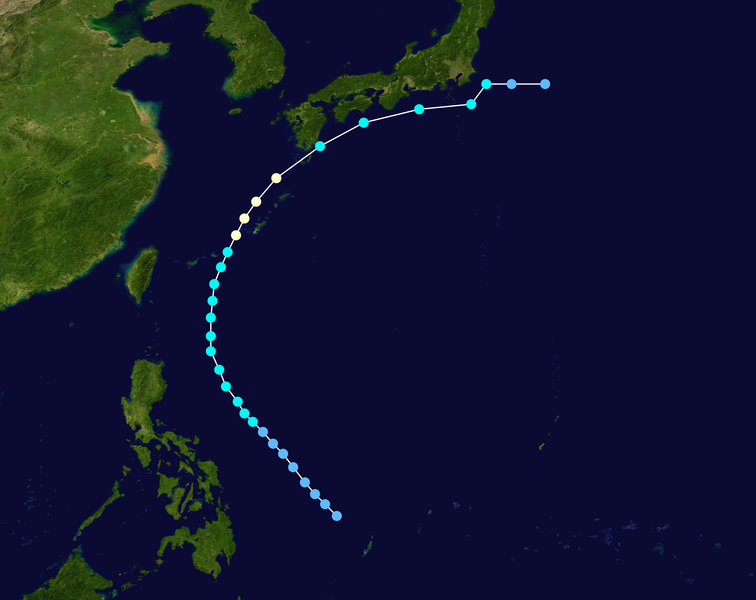
English: Track map of Typhoon Opal of the 1945 Pacific typhoon season. The points show the location of the storm at 6-hour intervals. The colour represents the storm's maximum sustained wind speeds as classified in the (see below), and the shape of the data points represent the nature of the storm, according to the legend below. Tropical depression (≤38 mph, ≤62 km/h)
Tropical storm (39–73 mph, 63–118 km/h)
Category 1 (74–95 mph, 119–153 km/h)
Category 2 (96–110 mph, 154–177 km/h)
Category 3 (111–129 mph, 178–208 km/h)
Category 4 (130–156 mph, 209–251 km/h)
Category 5 (≥157 mph, ≥252 km/h)
Unknown
Storm type |
||
| Date | 1945-07-08–1945-07-22 | ||
| Source | Created by Supportstorm using Wikipedia:WikiProject Tropical cyclones/Tracks. The background image is from NASA. Tracking data is from the International Best Track Archive for Climate Stewardship (IBTrACS)[1]. | ||
| Author | Supportstorm | ||
| Source code | Track map data table, if present below, is in HURDAT2 or ATCF format. See format details in [2] and [3], respectively.
|
Licensing
[edit]| This work has been released into the public domain by its author, Supportstorm. This applies worldwide. In some countries this may not be legally possible; if so: Supportstorm grants anyone the right to use this work for any purpose, without any conditions, unless such conditions are required by law. |
File history
Click on a date/time to view the file as it appeared at that time.
| Date/Time | Thumbnail | Dimensions | User | Comment | |
|---|---|---|---|---|---|
| current | 18:34, 29 September 2019 | | 2,700 × 2,142 (2.04 MB) | Supportstorm (talk | contribs) | Corrections |
| 03:05, 31 October 2016 |  | 2,700 × 2,142 (2.04 MB) | Supportstorm (talk | contribs) | Higher resolution (Better track from td9636 in codebox. Didn't include because it radically changes the track) | |
| 19:03, 13 December 2009 |  | 1,024 × 812 (353 KB) | Iune (talk | contribs) | {{Information |Description={{en|Track map of Typhoon Opal of the 1945 Pacific typhoon season. The points show the location of the storm at 6-hour intervals. The colour re |
You cannot overwrite this file.
File usage on Commons
The following page uses this file:
File usage on other wikis
The following other wikis use this file:
- Usage on en.wikipedia.org
- Usage on zh.wikipedia.org