File:Ontario Line route.svg
Jump to navigation
Jump to search

Size of this PNG preview of this SVG file: 695 × 600 pixels. Other resolutions: 278 × 240 pixels | 557 × 480 pixels | 890 × 768 pixels | 1,187 × 1,024 pixels | 2,374 × 2,048 pixels | 1,063 × 917 pixels.
Original file (SVG file, nominally 1,063 × 917 pixels, file size: 680 KB)
Captions
Captions
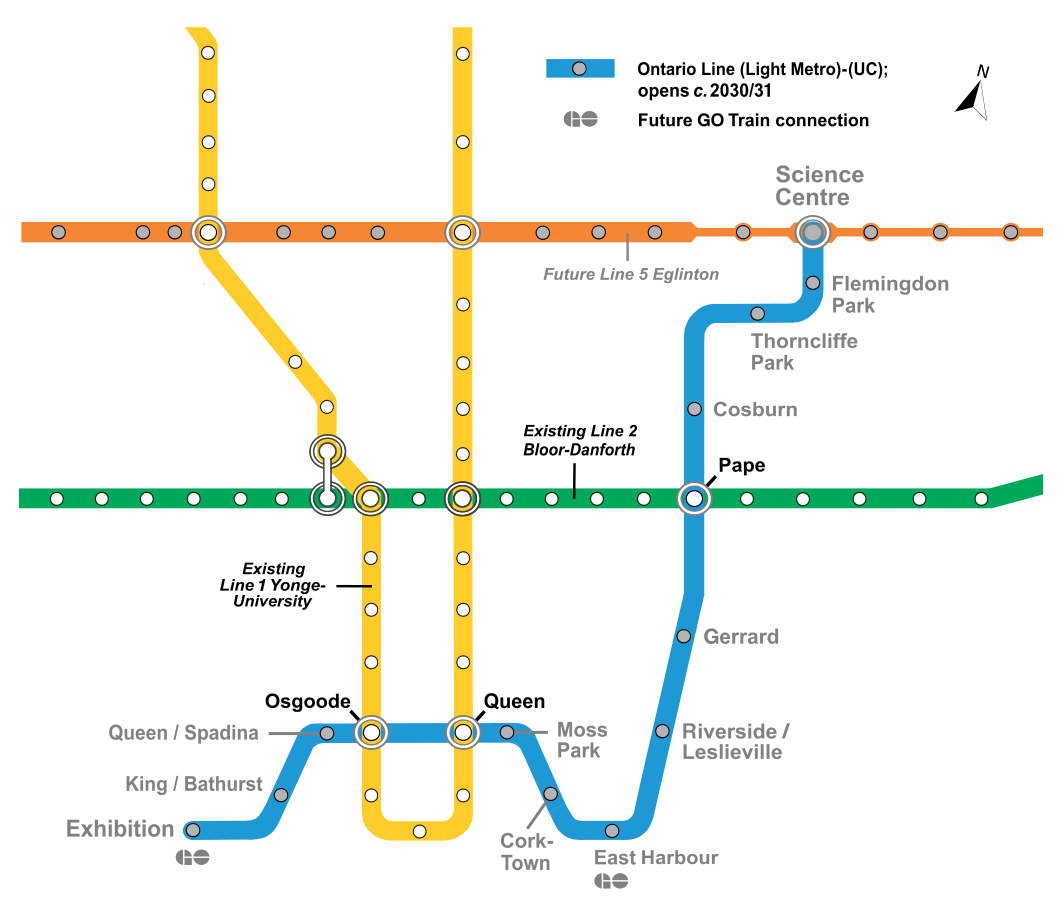
The Ontario Line as it will appear on system maps after opening, with the under-construction Line 5 Eglinton (across top) also shown
Summary
[edit]
| Description |
English: Map of future Ontario Line in Toronto with the under-construction Line 5 Eglinton (across top) also shown. |
| Date | |
| Source | TTC subway/RT map (as of 2022); based on map at https://www.ttc.ca/PDF/Maps/Subway_Map.pdf. Modified from self-made map |
| Author | Transportfan70 (Original by Craftwerker |
| Permission (Reusing this file) |
File:TTC_subway_map_2015.svg |
Licensing
[edit]
This file is licensed under the Creative Commons Attribution-Share Alike 4.0 International license.
- You are free:
- to share – to copy, distribute and transmit the work
- to remix – to adapt the work
- Under the following conditions:
- attribution – You must give appropriate credit, provide a link to the license, and indicate if changes were made. You may do so in any reasonable manner, but not in any way that suggests the licensor endorses you or your use.
- share alike – If you remix, transform, or build upon the material, you must distribute your contributions under the same or compatible license as the original.
File history
Click on a date/time to view the file as it appeared at that time.
| Date/Time | Thumbnail | Dimensions | User | Comment | |
|---|---|---|---|---|---|
| current | 13:24, 3 March 2024 | | 1,063 × 917 (680 KB) | Transportfan70 (talk | contribs) | '' |
| 18:29, 21 February 2024 |  | 1,063 × 926 (703 KB) | Transportfan70 (talk | contribs) | Changed map to revised line color | |
| 14:11, 19 September 2022 |  | 1,063 × 926 (694 KB) | Transportfan70 (talk | contribs) | Added Exhibition GO station | |
| 06:16, 19 September 2022 |  | 1,063 × 926 (694 KB) | Transportfan70 (talk | contribs) | Shifted station name | |
| 06:11, 19 September 2022 |  | 1,063 × 926 (694 KB) | Transportfan70 (talk | contribs) | Minor tweaks | |
| 05:20, 19 September 2022 |  | 1,063 × 926 (694 KB) | Transportfan70 (talk | contribs) | Uploaded a work by Transportfan70 (Original by Craftwerker from TTC subway/RT map (as of 2022); based on map at https://www.ttc.ca/PDF/Maps/Subway_Map.pdf. Modified from self-made map with UploadWizard |
You cannot overwrite this file.
File usage on Commons
The following 9 pages use this file:
- User:*Youngjin/GTA transit/2022 September
- User:*Youngjin/GTA transit/2024 February
- User:*Youngjin/GTA transit/2024 March
- User:Chumwa/OgreBot/Public transport information/2022 September 11-20
- User:Chumwa/OgreBot/Public transport information/2024 February 20-29
- User:Chumwa/OgreBot/Public transport information/2024 March 1-10
- User:Chumwa/OgreBot/Transport Maps/2022 September 11-20
- User:Chumwa/OgreBot/Transport Maps/2024 February 20-29
- User:Chumwa/OgreBot/Transport Maps/2024 March 1-10
File usage on other wikis
The following other wikis use this file:
- Usage on de.wikivoyage.org
- Usage on en.wikipedia.org
- Usage on ko.wikipedia.org
- Usage on zh-yue.wikipedia.org