File:Ontario Election 2007 Riding Results Map.svg
Jump to navigation
Jump to search

Size of this PNG preview of this SVG file: 800 × 491 pixels. Other resolutions: 320 × 196 pixels | 640 × 393 pixels | 1,024 × 629 pixels | 1,280 × 786 pixels | 2,560 × 1,572 pixels | 3,130 × 1,922 pixels.
Original file (SVG file, nominally 3,130 × 1,922 pixels, file size: 10.09 MB)
Captions
Captions
Add a one-line explanation of what this file represents
Summary
[edit]
| Description |
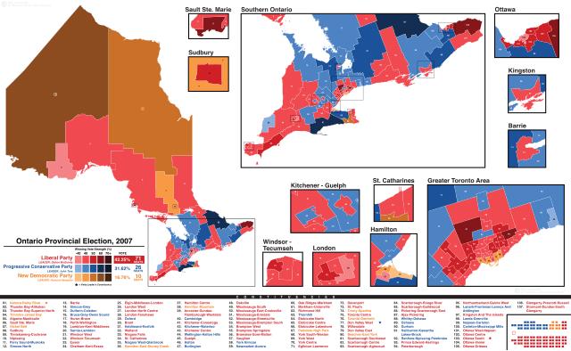
English: Ontario Election 2007 Riding Results Map |
| Date | |
| Source | Own work |
| Author | DrRandomFactor |
Licensing
[edit]
I, the copyright holder of this work, hereby publish it under the following license:
This file is licensed under the Creative Commons Attribution-Share Alike 4.0 International license.
- You are free:
- to share – to copy, distribute and transmit the work
- to remix – to adapt the work
- Under the following conditions:
- attribution – You must give appropriate credit, provide a link to the license, and indicate if changes were made. You may do so in any reasonable manner, but not in any way that suggests the licensor endorses you or your use.
- share alike – If you remix, transform, or build upon the material, you must distribute your contributions under the same or compatible license as the original.
File history
Click on a date/time to view the file as it appeared at that time.
| Date/Time | Thumbnail | Dimensions | User | Comment | |
|---|---|---|---|---|---|
| current | 20:09, 20 July 2019 | | 3,130 × 1,922 (10.09 MB) | DrRandomFactor (talk | contribs) | New format. |
| 18:48, 22 May 2018 |  | 2,002 × 1,502 (1.72 MB) | DrRandomFactor (talk | contribs) | New format. | |
| 18:36, 21 September 2017 |  | 2,310 × 2,263 (521 KB) | DrRandomFactor (talk | contribs) | New Format - All of Ontario now shown as one. | |
| 21:48, 11 August 2017 |  | 4,811 × 3,692 (445 KB) | DrRandomFactor (talk | contribs) | Update to the NDP orange shades. | |
| 01:23, 30 March 2017 |  | 4,811 × 3,692 (442 KB) | DrRandomFactor (talk | contribs) | New format. | |
| 01:35, 25 November 2016 |  | 1,624 × 1,014 (313 KB) | DrRandomFactor (talk | contribs) | User created page with UploadWizard |
You cannot overwrite this file.
File usage on Commons
The following 7 pages use this file:
- User:DrRandomFactor
- User:Magog the Ogre/Political maps/2016 November 21-30
- User:Magog the Ogre/Political maps/2017 August 11-20
- User:Magog the Ogre/Political maps/2017 March 21-31
- User:Magog the Ogre/Political maps/2017 September 21-30
- User:Magog the Ogre/Political maps/2018 May 21-31
- User:Magog the Ogre/Political maps/2019 July 11-20
File usage on other wikis
The following other wikis use this file:
- Usage on en.wikipedia.org
- Usage on fr.wikipedia.org
- Usage on simple.wikipedia.org
- Usage on zh.wikipedia.org