File:Oldtrin1913map.JPG

Original file (1,050 × 1,463 pixels, file size: 221 KB, MIME type: image/jpeg)
Captions
Captions
Summary
[edit]
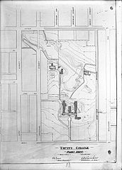
| Description | A map of the Trinity University grounds, now Trinity Bellwoods Park, as they appeared in 1913 |
| Date | |
| Source | City of Toronto Archives |
| Author | Unknown author |
| Permission (Reusing this file) |
no restrictions on these records |
Licensing
[edit]
This Canadian work is in the public domain in Canada because its copyright has expired due to one of the following:
it was not subject to Crown copyright, and
|
 |
File history
Click on a date/time to view the file as it appeared at that time.
| Date/Time | Thumbnail | Dimensions | User | Comment | |
|---|---|---|---|---|---|
| current | 21:56, 14 November 2007 | | 1,050 × 1,463 (221 KB) | Wachowich~commonswiki (talk | contribs) | {{Information |Description=A map of the Trinity grounds as they appeared in 1913 |Source=City of Toronto Archives |Date=1913 |Author=not given |Permission=no restrictions on these records |other_versions= }} |
You cannot overwrite this file.
File usage on Commons
There are no pages that use this file.