File:Old railway wall, Dromore - geograph.org.uk - 3098730.jpg
Jump to navigation
Jump to search
No higher resolution available.
Old_railway_wall,_Dromore_-_geograph.org.uk_-_3098730.jpg (640 × 427 pixels, file size: 98 KB, MIME type: image/jpeg)
Captions
Captions
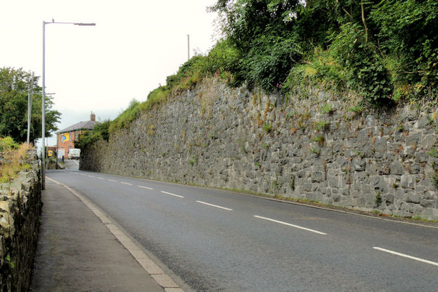
Old railway wall, Dromore
Summary
[edit]
| Description |
English: Old railway wall, Dromore An old wall at Church Street behind which lay Dromore station (closed in 1956). The station building remains (in other use) at middle left. The line came from the Hillsborough direction J2053 : Old railway near Dromore and continued (left) towards the viaduct J1953 : Dromore viaduct (1980-1) and Banbridge J1246 : Old railway bridge, Banbridge (3), after crossing the street by an overbridge. Although smaller than Banbridge, Dromore reputedly generated more passengers. On the other hand, Banbridge, with its many linen mills and larger agricultural hinterland, generated more goods. The remains of the course of the line can be seen in the Google satellite photograph. Best understood by looking at the 25” map (edition 3). |
| Date | |
| Source | From geograph.org.uk |
| Author | Albert Bridge |
| Permission (Reusing this file) |
Creative Commons Attribution Share-alike license 2.0 |
| Attribution (required by the license) | Albert Bridge / Old railway wall, Dromore / |
_-_geograph.org.uk_-_2614468.jpg)
_-_geograph.org.uk_-_341216.jpg)
| Camera location | | View this and other nearby images on: OpenStreetMap |
|---|
_heading:292.00&language=en)
| Object location | | View this and other nearby images on: OpenStreetMap |
|---|
_heading:292.00&language=en)
Licensing
[edit]

|
This image was taken from the Geograph project collection. See this photograph's page on the Geograph website for the photographer's contact details. The copyright on this image is owned by Albert Bridge and is licensed for reuse under the Creative Commons Attribution-ShareAlike 2.0 license.
|
This file is licensed under the Creative Commons Attribution-Share Alike 2.0 Generic license.
Attribution: Albert Bridge
- You are free:
- to share – to copy, distribute and transmit the work
- to remix – to adapt the work
- Under the following conditions:
- attribution – You must give appropriate credit, provide a link to the license, and indicate if changes were made. You may do so in any reasonable manner, but not in any way that suggests the licensor endorses you or your use.
- share alike – If you remix, transform, or build upon the material, you must distribute your contributions under the same or compatible license as the original.
File history
Click on a date/time to view the file as it appeared at that time.
| Date/Time | Thumbnail | Dimensions | User | Comment | |
|---|---|---|---|---|---|
| current | 09:43, 21 January 2022 | | 640 × 427 (98 KB) | GeographBot (talk | contribs) | Uploading geograph.org.uk image from https://www.geograph.org.uk/photo/3098730 |
You cannot overwrite this file.
File usage on Commons
There are no pages that use this file.