File:Oklahoma seismicity map.svg
Jump to navigation
Jump to search

Size of this PNG preview of this SVG file: 800 × 582 pixels. Other resolutions: 320 × 233 pixels | 640 × 465 pixels | 1,024 × 745 pixels | 1,280 × 931 pixels | 2,560 × 1,862 pixels | 990 × 720 pixels.
Original file (SVG file, nominally 990 × 720 pixels, file size: 9.21 MB)
Captions
Captions
Add a one-line explanation of what this file represents
Summary
[edit]| Description |
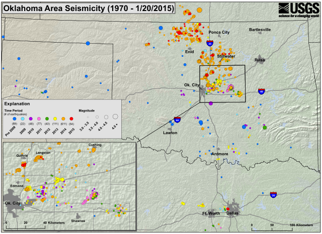
English: Seismicity map of earthquakes in the U.S. State of Oklahoma since 1970 known to have greater than or equal to 3.0 magnitude on the moment magnitude scale. |
|||
| Date | ||||
| Source | https://earthquake.usgs.gov/earthquakes/states/oklahoma/images/OKseismicity-01-20-2015_hires.pdf | |||
| Author |
Converted to SVG by User:Dustin V. S. Licensing
|
|||
| Other versions |
|

File history
Click on a date/time to view the file as it appeared at that time.
| Date/Time | Thumbnail | Dimensions | User | Comment | |
|---|---|---|---|---|---|
| current | 00:31, 30 April 2015 | | 990 × 720 (9.21 MB) | Master of Time (talk | contribs) | 2015-01-20 |
| 00:27, 30 April 2015 |  | 990 × 720 (2.78 MB) | Master of Time (talk | contribs) | =={{int:filedesc}}== {{Information |description={{en|1=Seismicity map of '''{{C|Earthquakes in Oklahoma|earthquakes in the U.S. State of Oklahoma}}''' since 1970 known to have greater than or equal to 3.0 magnitude on the moment magnitude scale.}} |dat... |
You cannot overwrite this file.
File usage on Commons
The following page uses this file:
- File:OKquakes1970 061714.svg (file redirect)