File:Oettingen Counties 1744.png
Jump to navigation
Jump to search

Size of this preview: 636 × 600 pixels. Other resolutions: 254 × 240 pixels | 509 × 480 pixels | 814 × 768 pixels | 1,086 × 1,024 pixels | 2,171 × 2,048 pixels | 3,664 × 3,456 pixels.
Original file (3,664 × 3,456 pixels, file size: 26.53 MB, MIME type: image/png)
Captions
Captions
Add a one-line explanation of what this file represents
Summary
[edit]
| Description |
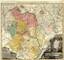
English: Map showing the territories of the House of Oettingen in the mid-18th century: the Principality of Oettingen (or Oettingen-Spielberg, in pink) and the Counties of Oettingen-Oettingen (light yellow), Oettingen-Baldern (aqua) and Oettingen-Wallerstein (yellow). Also shown (in purple) are the territories of the free imperial cities of Nördlingen (with its half-dozen exclaves), Bopfingen and Dinkelsbühl. The map, which contains information in Latin, French and German, was designed by M. F. Cnopf and published by Homann Erben (Homann Heirs) in 1744. |
| Date | |
| Source | Moll's map collection |
| Author | M. F. Cnopf - Homann Heirs |
Licensing
[edit]
|
This work is in the public domain in its country of origin and other countries and areas where the copyright term is the author's life plus 100 years or fewer. | |
| This file has been identified as being free of known restrictions under copyright law, including all related and neighboring rights. | |
File history
Click on a date/time to view the file as it appeared at that time.
| Date/Time | Thumbnail | Dimensions | User | Comment | |
|---|---|---|---|---|---|
| current | 23:39, 2 July 2018 | | 3,664 × 3,456 (26.53 MB) | Lubiesque (talk | contribs) | User created page with UploadWizard |
You cannot overwrite this file.
File usage on Commons
There are no pages that use this file.
File usage on other wikis
The following other wikis use this file:
- Usage on cs.wikipedia.org
- Usage on de.wikipedia.org
- Usage on de.wikisource.org
- Usage on en.wikipedia.org
- Usage on he.wikipedia.org
- Usage on nl.wikipedia.org
- Usage on ru.wikipedia.org