File:Oceanic-continental destructive plate boundary.svg
Jump to navigation
Jump to search

Size of this PNG preview of this SVG file: 800 × 569 pixels. Other resolutions: 320 × 228 pixels | 640 × 455 pixels | 1,024 × 729 pixels | 1,280 × 911 pixels | 2,560 × 1,822 pixels | 2,688 × 1,913 pixels.
Original file (SVG file, nominally 2,688 × 1,913 pixels, file size: 7 KB)
Captions
Captions
Add a one-line explanation of what this file represents
Summary
[edit]| Description |
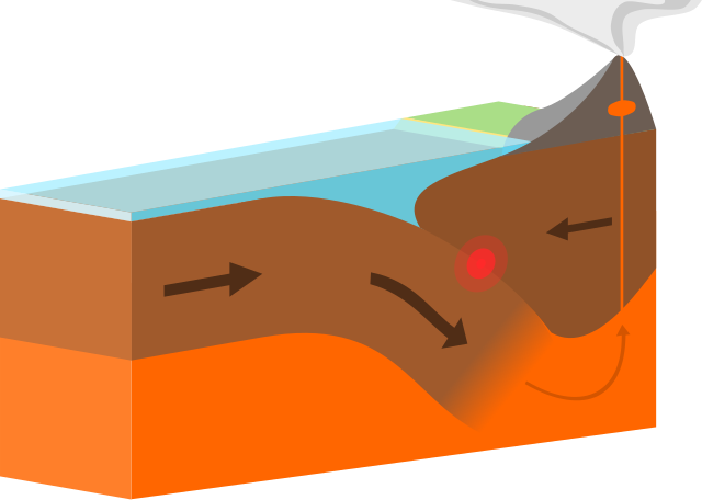
English: A destructive/convergent plate margin/boundary with an oceanic plate subducting under a continental plate. No labels, only arrows now, so it's language neutral, but someone may want to add them, or I might if I can be bothered to get round to it.
My first work in Inkscape ever, took me ages but I learnt a lot! A 3D orthogonal projection (at 10 degrees), 'flat colours' style, which I like the look of (and is easier for me to do). Might get to work on the other boundaries soon |
| Date | |
| Source | Own work |
| Author | domdomegg |
| Other versions |
|


Licensing
[edit]
I, the copyright holder of this work, hereby publish it under the following license:
This file is licensed under the Creative Commons Attribution 4.0 International license.
- You are free:
- to share – to copy, distribute and transmit the work
- to remix – to adapt the work
- Under the following conditions:
- attribution – You must give appropriate credit, provide a link to the license, and indicate if changes were made. You may do so in any reasonable manner, but not in any way that suggests the licensor endorses you or your use.
File history
Click on a date/time to view the file as it appeared at that time.
| Date/Time | Thumbnail | Dimensions | User | Comment | |
|---|---|---|---|---|---|
| current | 21:21, 24 December 2015 | | 2,688 × 1,913 (7 KB) | Domdomegg (talk | contribs) | Compressed |
| 12:10, 19 December 2015 |  | 2,688 × 1,913 (16 KB) | Domdomegg (talk | contribs) | Added arrows | |
| 11:54, 19 December 2015 |  | 2,688 × 1,913 (14 KB) | Domdomegg (talk | contribs) | User created page with UploadWizard |
You cannot overwrite this file.
File usage on Commons
The following 10 pages use this file:
- File:Continental-continental conservative plate boundary opposite directions.svg
- File:Continental-continental conservative plate boundary same direction.svg
- File:Continental-continental constructive plate boundary.svg
- File:Continental-continental destructive plate boundary.svg
- File:Destructive plate boundary.svg (file redirect)
- File:Oceanic-continental destructive plate boundary.svg
- File:Oceanic-oceanic constructive plate boundary.svg
- File:Oceanic-oceanic destructive plate boundary.svg
- File:Plate boundary diagram assets pack.svg
- Template:Other versions/Plate boundary diagrams
File usage on other wikis
The following other wikis use this file:
- Usage on ca.wiktionary.org
- Usage on da.wikipedia.org
- Usage on en.wikipedia.org
- Usage on en.wiktionary.org
- Usage on eu.wikipedia.org
- Usage on fa.wikipedia.org
- Usage on ga.wikipedia.org
- Usage on hi.wikipedia.org
- Usage on ko.wikipedia.org
- Usage on te.wikipedia.org
- Usage on tr.wikipedia.org
- Usage on www.wikidata.org