File:Ob watershed ru.png
Jump to navigation
Jump to search
No higher resolution available.
Ob_watershed_ru.png (300 × 300 pixels, file size: 46 KB, MIME type: image/png)
Captions
Captions
Add a one-line explanation of what this file represents
Summary
[edit]
Karl Musser created it based on USGS data.

|
This map image could be re-created using vector graphics as an SVG file. This has several advantages; see Commons:Media for cleanup for more information. If an SVG form of this image is available, please upload it and afterwards replace this template with
{{vector version available|new image name}}.
It is recommended to name the SVG file “Ob watershed ru.svg”—then the template Vector version available (or Vva) does not need the new image name parameter. |
Licensing
[edit]
| This file is licensed under the Creative Commons Attribution-Share Alike 3.0 Unported license. Subject to disclaimers. | ||
| ||
| This licensing tag was added to this file as part of the GFDL licensing update. |

|
Permission is granted to copy, distribute and/or modify this document under the terms of the GNU Free Documentation License, Version 1.2 or any later version published by the Free Software Foundation; with no Invariant Sections, no Front-Cover Texts, and no Back-Cover Texts. A copy of the license is included in the section entitled GNU Free Documentation License. Subject to disclaimers. |
File history
Click on a date/time to view the file as it appeared at that time.
| Date/Time | Thumbnail | Dimensions | User | Comment | |
|---|---|---|---|---|---|
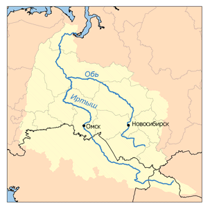
| current | 14:34, 10 January 2008 | | 300 × 300 (46 KB) | Chesnok (talk | contribs) | This is a map of the Ob River Watershed (at the confluence with the Irtysh river). Karl Musser created it based on USGS data. Category:Maps of rivers of Asia Category:Ob River [[C |
You cannot overwrite this file.
File usage on Commons
The following page uses this file:
File usage on other wikis
The following other wikis use this file:
- Usage on be-tarask.wikipedia.org
- Usage on kk.wikipedia.org
- Usage on uk.wikipedia.org
- Usage on www.wikidata.org