File:ORD Airport Diagram.svg
Jump to navigation
Jump to search

Size of this PNG preview of this SVG file: 390 × 599 pixels. Other resolutions: 156 × 240 pixels | 313 × 480 pixels | 500 × 768 pixels | 667 × 1,024 pixels | 1,334 × 2,048 pixels | 484 × 743 pixels.
Original file (SVG file, nominally 484 × 743 pixels, file size: 3.46 MB)
Captions
Captions
Add a one-line explanation of what this file represents
Summary
[edit]
| Description |
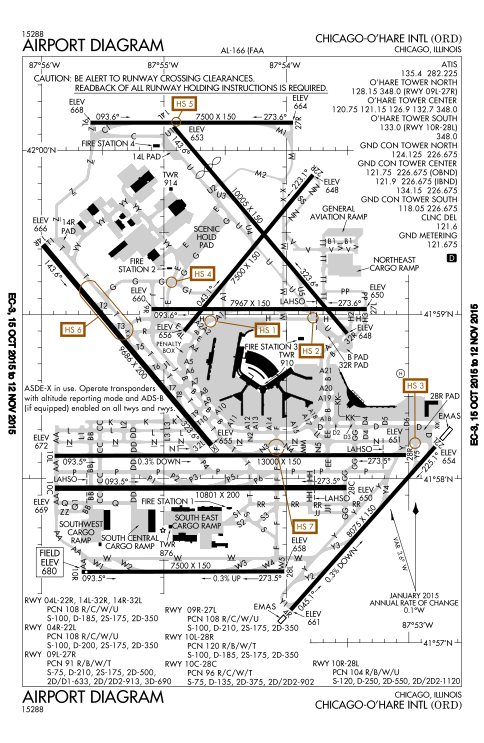
English: FAA Airport Diagram of O'Hare International Airport. |
| Date | |
| Source |
FAA Airport Diagrams; note that these change every 28 days. Taken from PDF on FAA site and converted to SVG using en:Wikipedia:How to draw SVG circuits using Xcircuit. |
| Author | Produced by the National Aeronautical Charting Office (NACO), a department of the United States en:Federal Aviation Administration. |
| Camera location | | View this and other nearby images on: OpenStreetMap |
|---|
W3C-validity not checked.
Licensing
[edit]
This image or file is a work of a Federal Aviation Administration employee, taken or made as part of that person's official duties. As a work of the U.S. federal government, the image is in the public domain in the United States.
|
 |
File history
Click on a date/time to view the file as it appeared at that time.
| Date/Time | Thumbnail | Dimensions | User | Comment | |
|---|---|---|---|---|---|
| current | 21:27, 15 October 2015 | | 484 × 743 (3.46 MB) | BorgHunter (talk | contribs) | New diagram with 10R/28L |
| 14:36, 8 November 2014 |  | 484 × 743 (1.63 MB) | BorgHunter (talk | contribs) | Updated diagram includes runway 28C | |
| 14:02, 2 May 2013 |  | 378 × 547 (1.62 MB) | Grendelkhan (talk | contribs) | SVG version of FAA's PDF diagram. |
You cannot overwrite this file.
File usage on Commons
The following 7 pages use this file:
- User:Chumwa/OgreBot/Transport Maps/2015 October 11-20
- Commons:WikiProject Aviation/recent uploads/2013 May 1-10
- Commons:WikiProject Aviation/recent uploads/2015 October 15
- File:ORD airport map.PNG
- File:ORD airport map.gif
- Category:Maps of O'Hare International Airport
- Category:O'Hare International Airport
File usage on other wikis
The following other wikis use this file:
- Usage on ar.wikipedia.org
- Usage on de.wikipedia.org
- Usage on en.wikipedia.org
- Usage on eo.wikipedia.org
- Usage on fr.wikipedia.org
- Usage on hi.wikipedia.org
- Usage on it.wikipedia.org
- Usage on ja.wikipedia.org
- Usage on ko.wikipedia.org
- Usage on pl.wikipedia.org
- Usage on ru.wikipedia.org
- Usage on sk.wikipedia.org
- Usage on sl.wikipedia.org
- Usage on th.wikipedia.org
- Usage on www.wikidata.org