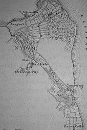
File:Nydam Mose map 1859-1863 retouched.png

Original file (1,704 × 2,560 pixels, file size: 1.21 MB, MIME type: image/png)
Captions
Captions
Summary
[edit]| DescriptionNydam Mose map 1859-1863 retouched.png |
English: Historical map of Nydam Mose (Nydam moor), part of Sønderborg Kommune, archaeological site in Denmark. Retouched version of a map presumably created by Helvig Conrad Engelhardt (1825–1881), Danish archaeologist. See below for previous version of this digital reproduction.
Deutsch: Historische Karte des Nydam mose (Nydam-Moor), archäologische Ausgrabungsstätte in der Gemeinde Sønderborg, Dänemark. Retuschierte Fassung einer Karte, gezeichnet vermutlich von Helvig Conrad Engelhardt (1825–1881), dänischer Archäologe. Ältere Version der Reproduktion: siehe unten. |
| Date | 1859–1863 |
| Source |
 |
| Author | Unknown authorUnknown author |
Licensing
[edit]| Public domainPublic domainfalsefalse |
|
This work is in the public domain in its country of origin and other countries and areas where the copyright term is the author's life plus 100 years or fewer. | |
| This file has been identified as being free of known restrictions under copyright law, including all related and neighboring rights. | |
https://creativecommons.org/publicdomain/mark/1.0/PDMCreative Commons Public Domain Mark 1.0falsefalse
File history
Click on a date/time to view the file as it appeared at that time.
| Date/Time | Thumbnail | Dimensions | User | Comment | |
|---|---|---|---|---|---|
| current | 18:40, 18 January 2018 |  | 1,704 × 2,560 (1.21 MB) | Frank Behnsen (talk | contribs) | == {{int:filedesc}} == {{Information |Description ={{en|1=Historical map of ''Nydam Mose'' (Nydam moor), part of ''Sønderborg Kommune,'' archaeological site in Denmark. Retouched version of a map presumably created by [[:de:Helvig Conrad Engelhardt... |
You cannot overwrite this file.
File usage on Commons
The following page uses this file:
Metadata
This file contains additional information such as Exif metadata which may have been added by the digital camera, scanner, or software program used to create or digitize it. If the file has been modified from its original state, some details such as the timestamp may not fully reflect those of the original file. The timestamp is only as accurate as the clock in the camera, and it may be completely wrong.
| Color space | sRGB |
|---|---|
| Software used | Windows Photo Editor 6.3.9600.17418 |
| Horizontal resolution | 118.11 dpc |
| Vertical resolution | 118.11 dpc |