File:Nuremberg network map.png
Jump to navigation
Jump to search
Size of this preview: 800 × 541 pixels. Other resolutions: 320 × 216 pixels | 640 × 433 pixels | 1,024 × 693 pixels | 1,280 × 866 pixels | 2,560 × 1,732 pixels | 4,964 × 3,358 pixels.
Original file (4,964 × 3,358 pixels, file size: 1.78 MB, MIME type: image/png)
Captions
Captions
Add a one-line explanation of what this file represents
Summary
[edit]
| Description |
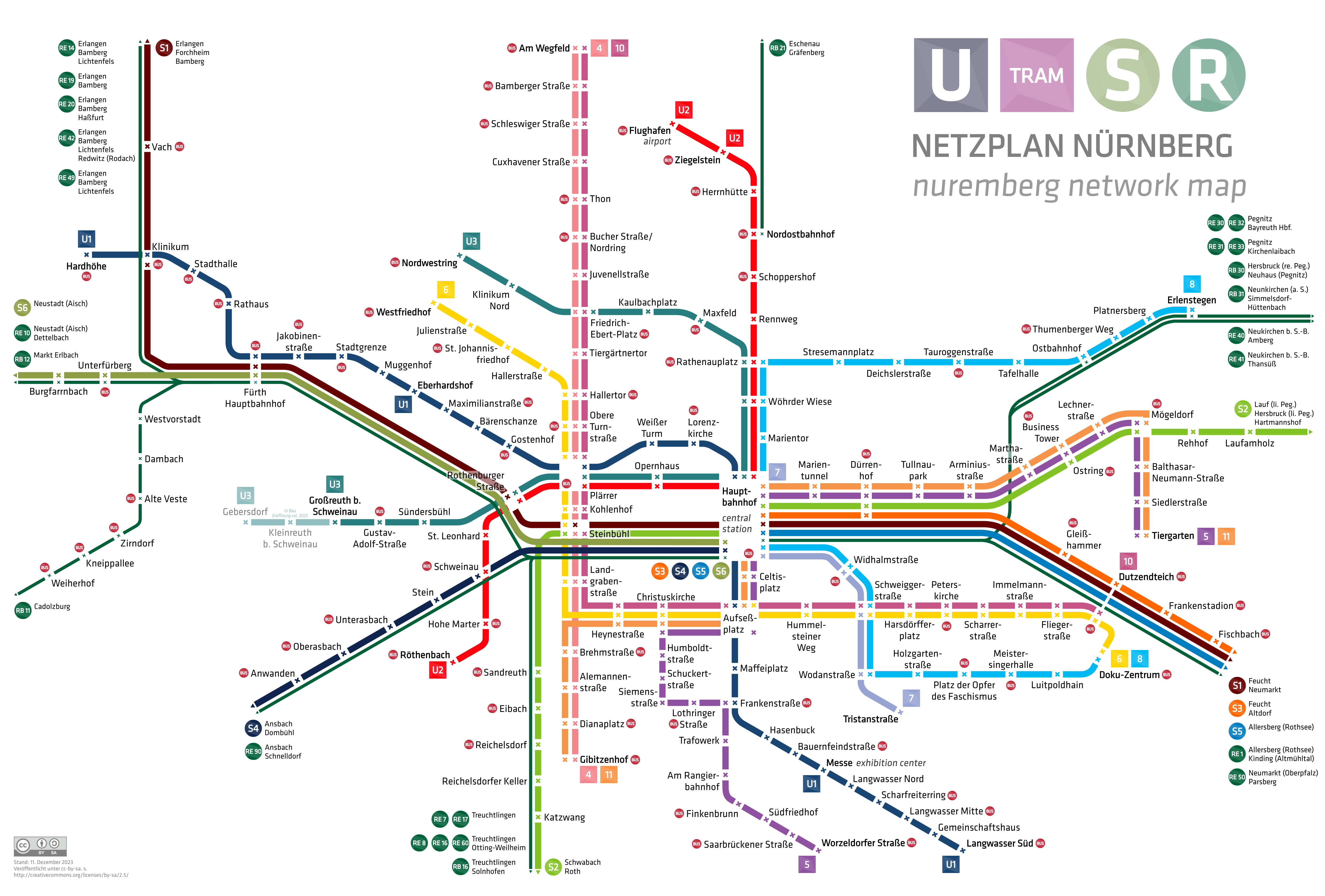
English: nuremberg city network map with underground, tramway, suburban railway and regional railway
|
| Date | |
| Source | Own work |
| Author | HerrMay |
Licensing
[edit]
I, the copyright holder of this work, hereby publish it under the following license:
| This file is made available under the Creative Commons CC0 1.0 Universal Public Domain Dedication. | |
| The person who associated a work with this deed has dedicated the work to the public domain by waiving all of their rights to the work worldwide under copyright law, including all related and neighboring rights, to the extent allowed by law. You can copy, modify, distribute and perform the work, even for commercial purposes, all without asking permission.
|
File history
Click on a date/time to view the file as it appeared at that time.
| Date/Time | Thumbnail | Dimensions | User | Comment | |
|---|---|---|---|---|---|
| current | 01:44, 2 May 2024 | | 4,964 × 3,358 (1.78 MB) | HerrMay (talk | contribs) | aktualisiert |
| 20:13, 19 December 2023 |  | 4,964 × 3,358 (1.78 MB) | HerrMay (talk | contribs) | Kleine Ausbesserungen | |
| 05:43, 9 December 2023 |  | 4,964 × 3,358 (1.78 MB) | HerrMay (talk | contribs) | aktualisiert | |
| 23:19, 20 January 2022 |  | 4,964 × 3,358 (1.74 MB) | HerrMay (talk | contribs) | Fürther Stationen ausgebessert | |
| 06:06, 20 December 2021 |  | 4,964 × 3,358 (1.75 MB) | HerrMay (talk | contribs) | Namen ausgebessert | |
| 00:27, 7 December 2021 |  | 4,964 × 3,358 (1.75 MB) | HerrMay (talk | contribs) | S6 hinzugefügt | |
| 03:06, 15 October 2020 |  | 4,964 × 3,358 (1.63 MB) | HerrMay (talk | contribs) | U3 Verlängerung | |
| 16:27, 4 October 2020 |  | 4,964 × 3,358 (1.63 MB) | HerrMay (talk | contribs) | Stationsnamen korrigiert | |
| 16:17, 15 May 2020 |  | 4,964 × 3,358 (1.64 MB) | HerrMay (talk | contribs) | Ausbesserung Namen Thum(m)enberger Weg, Scheu(e)rlstraße | |
| 22:59, 20 April 2020 |  | 4,964 × 3,358 (1.64 MB) | HerrMay (talk | contribs) | aktualisiert Anwanden, Oberasbach |
You cannot overwrite this file.
File usage on Commons
The following 47 pages use this file:
- Nürnberg U-Bahn
- Rapid transit
- User:Chumwa/OgreBot/Potential transport maps/2016 December 21-31
- User:Chumwa/OgreBot/Potential transport maps/2017 December 11-20
- User:Chumwa/OgreBot/Potential transport maps/2017 May 11-20
- User:Chumwa/OgreBot/Potential transport maps/2018 March 1-10
- User:Chumwa/OgreBot/Potential transport maps/2019 March 1-10
- User:Chumwa/OgreBot/Public transport information/2016 December 21-31
- User:Chumwa/OgreBot/Public transport information/2017 December 11-20
- User:Chumwa/OgreBot/Public transport information/2017 May 11-20
- User:Chumwa/OgreBot/Public transport information/2018 March 1-10
- User:Chumwa/OgreBot/Public transport information/2019 March 1-10
- User:Chumwa/OgreBot/Public transport information/2020 April 11-20
- User:Chumwa/OgreBot/Public transport information/2020 February 20-29
- User:Chumwa/OgreBot/Public transport information/2020 May 11-20
- User:Chumwa/OgreBot/Public transport information/2020 October 1-10
- User:Chumwa/OgreBot/Public transport information/2020 October 11-20
- User:Chumwa/OgreBot/Public transport information/2021 December 1-10
- User:Chumwa/OgreBot/Public transport information/2021 December 11-20
- User:Chumwa/OgreBot/Public transport information/2022 January 11-20
- User:Chumwa/OgreBot/Public transport information/2023 December 1-10
- User:Chumwa/OgreBot/Public transport information/2023 December 11-20
- User:Chumwa/OgreBot/Public transport information/2024 May 1-10
- User:Chumwa/OgreBot/Transport Maps/2016 December 21-31
- User:Chumwa/OgreBot/Transport Maps/2017 December 11-20
- User:Chumwa/OgreBot/Transport Maps/2017 May 11-20
- User:Chumwa/OgreBot/Transport Maps/2018 March 1-10
- User:Chumwa/OgreBot/Transport Maps/2019 March 1-10
- User:Chumwa/OgreBot/Transport Maps/2020 April 11-20
- User:Chumwa/OgreBot/Transport Maps/2020 February 20-29
- User:Chumwa/OgreBot/Transport Maps/2020 May 11-20
- User:Chumwa/OgreBot/Transport Maps/2020 October 1-10
- User:Chumwa/OgreBot/Transport Maps/2020 October 11-20
- User:Chumwa/OgreBot/Transport Maps/2021 December 1-10
- User:Chumwa/OgreBot/Transport Maps/2021 December 11-20
- User:Chumwa/OgreBot/Transport Maps/2022 January 11-20
- User:Chumwa/OgreBot/Transport Maps/2023 December 1-10
- User:Chumwa/OgreBot/Transport Maps/2023 December 11-20
- User:Chumwa/OgreBot/Transport Maps/2024 May 1-10
- User:Chumwa/OgreBot/Travel and communication maps/2016 December 21-31
- User:Chumwa/OgreBot/Travel and communication maps/2017 December 11-20
- User:Chumwa/OgreBot/Travel and communication maps/2017 May 11-20
- User:Chumwa/OgreBot/Travel and communication maps/2018 March 1-10
- User:Chumwa/OgreBot/Travel and communication maps/2019 March 1-10
- User:Chumwa/OgreBot/Travel and communication maps/2024 May 1-10
- User:HerrMay
- Category:Verkehrsverbund Großraum Nürnberg
File usage on other wikis
The following other wikis use this file:
- Usage on ast.wikipedia.org
- Usage on cs.wikipedia.org
- Usage on de.wikipedia.org
- Usage on de.wikivoyage.org
- Usage on en.wikipedia.org
- Usage on en.wikivoyage.org
- Usage on eo.wikipedia.org
- Usage on es.wikipedia.org
- Usage on eu.wikipedia.org
- Usage on fa.wikipedia.org
- Usage on fi.wikipedia.org
- Usage on fr.wikipedia.org
- Usage on hu.wikipedia.org
- Usage on id.wikipedia.org
- Usage on ja.wikipedia.org
- Usage on ka.wikipedia.org
- Usage on ko.wikipedia.org
- Usage on lt.wikipedia.org
- Usage on mhr.wikipedia.org
- Usage on no.wikipedia.org
- Usage on pl.wikivoyage.org
- Usage on simple.wikipedia.org
- Usage on sk.wikipedia.org
- Usage on uz.wikipedia.org
- Usage on www.wikidata.org