File:Nuovo Trasporto Viaggiatori.jpg
Jump to navigation
Jump to search

Size of this preview: 523 × 599 pixels. Other resolutions: 209 × 240 pixels | 419 × 480 pixels | 670 × 768 pixels | 1,152 × 1,320 pixels.
Original file (1,152 × 1,320 pixels, file size: 801 KB, MIME type: image/jpeg)
Captions
Captions
Add a one-line explanation of what this file represents
Summary
[edit]
| Description |
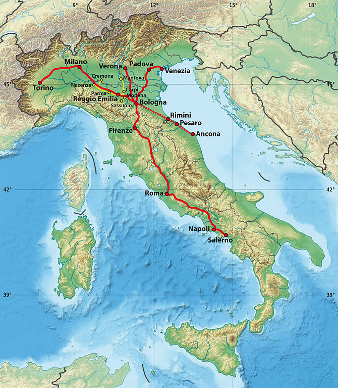
Deutsch: Streckennetz des Nuovo Trasporto Viaggiatori; rot: Bahnlinien, rot gepunktet: nur im Sommer, gelb: Buslinien
English: Routes of Nuovo Trasporto Viaggiatori; red: trains, red dotted: in summer only, yellow: buses |
| Date | (UTC) |
| Source |
This file was derived from: Italy relief location map.jpg |
| Author |
|

|
This map has been made or improved in the German Kartenwerkstatt (Map Lab). You can propose maps to improve as well.
|
Licensing
[edit]
This file is licensed under the Creative Commons Attribution-Share Alike 3.0 Unported license.
- You are free:
- to share – to copy, distribute and transmit the work
- to remix – to adapt the work
- Under the following conditions:
- attribution – You must give appropriate credit, provide a link to the license, and indicate if changes were made. You may do so in any reasonable manner, but not in any way that suggests the licensor endorses you or your use.
- share alike – If you remix, transform, or build upon the material, you must distribute your contributions under the same or compatible license as the original.
Original upload log
[edit]
This image is a derivative work of the following images:
- File:Italy_relief_location_map.jpg licensed with Cc-by-sa-3.0, GFDL
- 2010-07-19T12:20:14Z Sting 1034x1299 (459742 Bytes) Color profile
- 2009-09-14T12:23:52Z Sting 1034x1299 (538646 Bytes) updating borders after important variation (http://www.gazzettaufficiale.it/guridb/dispatcher?service=1&datagu=2009-08-14&task=dettaglio&numgu=188&redaz=009G0127&tmstp=1250276942469) - cf [[:File:Italy_location_map.svg]]
- 2009-05-06T20:31:50Z Sting 1034x1299 (538462 Bytes) == Summary == {{Location|41|21|00|N|12|36|00|E|scale:5000000}} {{Information |Description={{en|Blank physical map of [[:en:Italy|Italy]], for geo-location purpose.}} {{fr|Carte physique vierge de l'[[:fr:Italie|Italie]], des
File history
Click on a date/time to view the file as it appeared at that time.
| Date/Time | Thumbnail | Dimensions | User | Comment | |
|---|---|---|---|---|---|
| current | 10:02, 18 December 2015 | | 1,152 × 1,320 (801 KB) | NordNordWest (talk | contribs) | upd |
| 21:44, 12 November 2014 |  | 1,152 × 1,320 (783 KB) | NordNordWest (talk | contribs) | upd | |
| 13:52, 23 April 2012 |  | 1,152 × 1,320 (779 KB) | NordNordWest (talk | contribs) | == {{int:filedesc}} == {{Information |Description={{de|Streckennetz des Nuovo Trasporto Viaggiatori}} {{en|Routes of Nuovo Trasporto Viaggiatori}} |Source={{Derived from|Italy reli... |
You cannot overwrite this file.
File usage on Commons
The following 3 pages use this file:
File usage on other wikis
The following other wikis use this file:
- Usage on ar.wikipedia.org
- Usage on de.wikipedia.org
- Usage on en.wikipedia.org
- Usage on es.wikipedia.org
- Usage on fi.wikipedia.org
- Usage on fr.wikipedia.org
- Usage on hu.wikipedia.org
- Usage on ja.wikipedia.org
- Usage on nl.wikipedia.org
- Usage on pl.wikipedia.org
- Usage on www.wikidata.org
- Usage on zh.wikipedia.org