File:Nuneaton and Bedworth UK locator map.svg
Jump to navigation
Jump to search

Size of this PNG preview of this SVG file: 493 × 599 pixels. Other resolutions: 197 × 240 pixels | 395 × 480 pixels | 632 × 768 pixels | 843 × 1,024 pixels | 1,686 × 2,048 pixels | 1,042 × 1,266 pixels.
Original file (SVG file, nominally 1,042 × 1,266 pixels, file size: 911 KB)
Captions
Captions
Add a one-line explanation of what this file represents
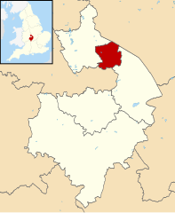
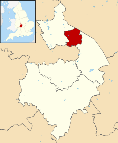
| Description | Map of Warwickshire, with Nuneaton and Bedworth highlighted. |
| Date | (UTC) |
| Source | |
| Author |
|
.svg)
I, the copyright holder of this work, hereby publish it under the following license:
This file is licensed under the Creative Commons Attribution-Share Alike 3.0 Unported license.
- You are free:
- to share – to copy, distribute and transmit the work
- to remix – to adapt the work
- Under the following conditions:
- attribution – You must give appropriate credit, provide a link to the license, and indicate if changes were made. You may do so in any reasonable manner, but not in any way that suggests the licensor endorses you or your use.
- share alike – If you remix, transform, or build upon the material, you must distribute your contributions under the same or compatible license as the original.
Original upload log
[edit]
This image is a derivative work of the following images:
- File:Warwickshire UK district map (blank).svg licensed with Cc-by-sa-3.0
- 2010-08-22T08:21:14Z Nilfanion 1042x1266 (931105 Bytes) +inset, water colour tweak
- 2010-07-16T23:57:57Z Nilfanion 1042x1266 (557360 Bytes) {{Information |Description=Map of [[w:Warwickshire|Warwickshire]], UK with districts shown. Equirectangular map projection on WGS 84 datum, with N/S stretched 160% Geographic limits: *West: 2.10W *East: 1.10W *North: 52.70N
File history
Click on a date/time to view the file as it appeared at that time.
| Date/Time | Thumbnail | Dimensions | User | Comment | |
|---|---|---|---|---|---|
| current | 09:21, 13 August 2011 | | 1,042 × 1,266 (911 KB) | Renly~commonswiki (talk | contribs) | {{Information |Description=Map of Warwickshire, with Nuneaton and Bedworth highlighted. |Source=*Warwickshire UK district map (blank).svg |Date=2011-08-13 09:21 (UTC) |Author=*[[:File:Warwickshire UK dist |
You cannot overwrite this file.
File usage on Commons
The following page uses this file:
File usage on other wikis
The following other wikis use this file:
- Usage on cy.wikipedia.org
- Usage on en.wikipedia.org
- Usage on es.wikipedia.org
- Usage on it.wikipedia.org
- Usage on ja.wikipedia.org
- Usage on ko.wikipedia.org
- Usage on lv.wikipedia.org
- Usage on nl.wikipedia.org
- Usage on pl.wikipedia.org
- Usage on ru.wikipedia.org
- Usage on sv.wikipedia.org
- Usage on ur.wikipedia.org