File:NuclideMap stitched.png
Jump to navigation
Jump to search

Size of this preview: 800 × 554 pixels. Other resolutions: 320 × 221 pixels | 640 × 443 pixels | 1,024 × 709 pixels | 1,280 × 886 pixels | 2,560 × 1,772 pixels | 13,019 × 9,010 pixels.
Original file (13,019 × 9,010 pixels, file size: 590 KB, MIME type: image/png)
Captions
Captions
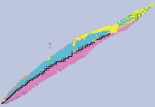
Map of known nuclides and their decay modes.
| Warning | The original file is very high-resolution. It might not load properly or could cause your browser to freeze when opened at full size. |
|---|
| Description |
English: Map of the nuclides
stable nuclide
alpha decay (moves atom ↙↙ two places diagonally down and to left)
beta+ / electron-capture decay (moves atom ↘ one place diagonally down and to right)
beta- decay (moves atom ↖ one place diagonally up and to left)
proton emission (moves atom ↓ one place down)
neutron emission (moves atom ← one place to left)
spontaneous fission (various products) |
| Date | (UTC) |
| Source | |
| Author |
|
| Other versions |
 |
| This is a retouched picture, which means that it has been digitally altered from its original version. Modifications: stitched. The original can be viewed here: NuclideMap.PNG:
|

|
File:NuclideMap.svg is a vector version of this file. It should be used in place of this PNG file when not inferior.
File:NuclideMap stitched.png → File:NuclideMap.svg
For more information, see Help:SVG. |
 |
| This image is a work of a United States Department of Energy (or predecessor organization) employee, taken or made as part of that person's official duties. As a work of the U.S. federal government, the image is in the public domain.
Please note that national laboratories operate under varying licences and some are not free. Check the site policies of any national lab before crediting it with this tag.
|

|
Original upload log
[edit]
This image is a derivative work of the following images:
- File:NuclideMap.PNG licensed with PD-USGov-DOE
- 2008-04-02T22:13:59Z The viewer 9610x4667 (4090032 Bytes) Map of nuclides Source: National Nuclear Data Center, information extracted from the NuDat 2 database, http://www.nndc.bnl.gov/nudat2/ License: "Users should feel free to use the information from NuDat 2 (tables and plots)
Uploaded with derivativeFX
File history
Click on a date/time to view the file as it appeared at that time.
| Date/Time | Thumbnail | Dimensions | User | Comment | |
|---|---|---|---|---|---|
| current | 09:42, 2 June 2013 | | 13,019 × 9,010 (590 KB) | Tehdog (talk | contribs) | Using a palette, reduced image size to 15% |
| 16:04, 30 July 2009 |  | 13,115 × 8,871 (3.3 MB) | Neokortex (talk | contribs) | colors changed, caption extended | |
| 15:44, 30 July 2009 |  | 13,115 × 8,871 (3.3 MB) | Neokortex (talk | contribs) | colors changed, caption extended | |
| 13:49, 28 July 2009 |  | 13,115 × 8,871 (3.95 MB) | Neokortex (talk | contribs) | {{Information |Description={{en|Map of the nuclides}} |Source=*File:NuclideMap.PNG |Date=2009-07-28 13:48 (UTC) |Author=*File:NuclideMap.PNG: The viewer *derivative work: ~~~ |Permission=see below |other_versions= }} {{RetouchedPicture|stitch |
You cannot overwrite this file.
File usage on Commons
The following page uses this file:
File usage on other wikis
The following other wikis use this file:
- Usage on en.wikipedia.org
- Usage on es.wikipedia.org
- Usage on eu.wikipedia.org
- Usage on ru.wikipedia.org
- Usage on sr.wikipedia.org