File:Nps1753-54.png
Jump to navigation
Jump to search

Size of this preview: 800 × 374 pixels. Other resolutions: 320 × 150 pixels | 640 × 299 pixels | 1,024 × 479 pixels | 1,280 × 599 pixels | 2,446 × 1,144 pixels.
Original file (2,446 × 1,144 pixels, file size: 1.84 MB, MIME type: image/png)
Captions
Captions
Add a one-line explanation of what this file represents
Summary
[edit]
| Description |
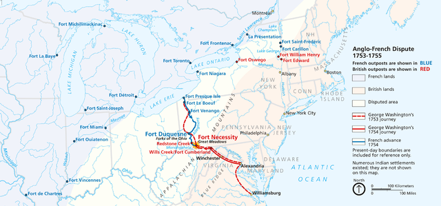
English: Maps of the English and French Campaigns in the Ohio Valley, 1753-54.
PNG file created via a screenshot of the flash map at the Fort Necessity National Battlefield Website (National Park Service) |
| Date | Unknown date |
| Source | National Park Service |
| Author | Unknown author |
Licensing
[edit]
| This image or media file contains material based on a work of a National Park Service employee, created as part of that person's official duties. As a work of the U.S. federal government, such work is in the public domain in the United States. See the NPS website and NPS copyright policy for more information. |
File history
Click on a date/time to view the file as it appeared at that time.
| Date/Time | Thumbnail | Dimensions | User | Comment | |
|---|---|---|---|---|---|
| current | 18:42, 22 September 2010 | | 2,446 × 1,144 (1.84 MB) | NordNordWest (talk | contribs) | higher resolution |
| 19:29, 22 August 2010 |  | 1,134 × 559 (768 KB) | Janneman (talk | contribs) | {{Information |Description={{en|1=Maps of the English and French Campaigns in the Ohio Valley, 1753-54. PNG file created via a screenshot of the flash map at the [http://www.nps.gov/fone/index.htm Fort Necessity National Battlefield Website] (National Par |
You cannot overwrite this file.
File usage on Commons
There are no pages that use this file.