File:Nowe Warpno (gmina) location map.png
Jump to navigation
Jump to search

Size of this preview: 571 × 599 pixels. Other resolutions: 229 × 240 pixels | 458 × 480 pixels | 794 × 833 pixels.
Original file (794 × 833 pixels, file size: 64 KB, MIME type: image/png)
Captions
Captions
Add a one-line explanation of what this file represents
| Description |
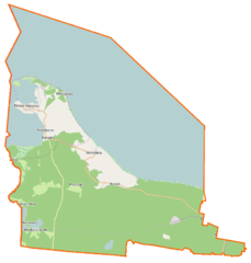
Polski: Mapa gminy Nowe Warpno, Polska
English: Map of Gmina Nowe Warpno, Poland |
|||||||||
| Date | ||||||||||
| Source | You may find a page on the OpenStreetMap wiki page for Nowe Warpno (gmina) | |||||||||
| Creator |
OpenStreetMap contributors OpenStreetMap contributors |
|||||||||
| Permission (Reusing this file) |
OpenStreetMap data is available under the Open Database License (details). Map tiles are licensed under the Creative Commons Attribution-ShareAlike 2.0 license (CC-BY-SA 2.0).
This file is licensed under the Creative Commons Attribution-Share Alike 2.0 Generic license.
|
|||||||||
| Geotemporal data | ||||||||||
| Bounding box |
|
|||||||||
| Georeferencing | If inappropriate please set warp_status = skip to hide. | |||||||||
File history
Click on a date/time to view the file as it appeared at that time.
| Date/Time | Thumbnail | Dimensions | User | Comment | |
|---|---|---|---|---|---|
| current | 11:21, 2 April 2015 | | 794 × 833 (64 KB) | VanWiel (talk | contribs) | {{OpenStreetMap | name = Nowe Warpno (gmina) | location = Nowe Warpno (gmina) | description = {{pl|Mapa gminy Nowe Warpno, Polska}} {{en|Map of Gmina Nowe Warpno, Poland}} | top = 53.7927 | bottom =... |
You cannot overwrite this file.
File usage on Commons
There are no pages that use this file.
File usage on other wikis
The following other wikis use this file:
- Usage on fr.wikipedia.org
- Usage on pl.wikipedia.org
- Nowe Warpno (gmina)
- Nowe Warpno
- Ratusz w Nowym Warpnie
- Kościół Wniebowzięcia Najświętszej Maryi Panny w Nowym Warpnie
- Kościół św. Huberta w Nowym Warpnie
- Podgrodzie (Nowe Warpno)
- Jezioro Nowowarpieńskie
- Myśliborka
- Jezioro Myśliborskie Wielkie
- Jezioro Myśliborskie Małe
- Piaski (jezioro w Puszczy Wkrzańskiej)
- Warnołęka
- Kościół Matki Bożej Częstochowskiej w Warnołęce
- Myślibórz Mały
- Myślibórz Wielki
- Mszczuje
- Łysa Wyspa
- Karszno
- Brzózki (województwo zachodniopomorskie)
- Maszkowo (Myślibórz Wielki)
- Popielewo (powiat policki)
- Port morski Nowe Warpno
- Trzebieradz (powiat policki)
- Miroszewo (Nowe Warpno)
- Półwysep Grodzki
- SLR Myślibórz Wielki
- Nowe Warpno (stacja kolejowa)
- Nowe Warpno Żalno
- Karszno (przystanek kolejowy)
- Parafia Wniebowzięcia Najświętszej Maryi Panny w Nowym Warpnie
- Cieszkowice (województwo zachodniopomorskie)
- Zatoka Nowowarpieńska
- Morskie przejście graniczne Nowe Warpno
- Białcz (powiat policki)
- Dobiesław (powiat policki)
- Zatoka Warnołęcka
- Gosienica
- Rytka
- Piaskowa Góra (Równina Wkrzańska)
- Karpinek (powiat policki)
- Pałac w Karsznie
- Moduł:Mapa/dane/Nowe Warpno
View more global usage of this file.
_location_map.png)
_location_map.png&oldid=519985655)