File:NouvelleFrance-Vraie-Version.png
Jump to navigation
Jump to search

Size of this preview: 800 × 570 pixels. Other resolutions: 320 × 228 pixels | 640 × 456 pixels | 1,024 × 730 pixels | 1,280 × 912 pixels | 1,530 × 1,090 pixels.
Original file (1,530 × 1,090 pixels, file size: 1.38 MB, MIME type: image/png)
Captions
Captions
Add a one-line explanation of what this file represents
Summary
[edit]
)
| Description |
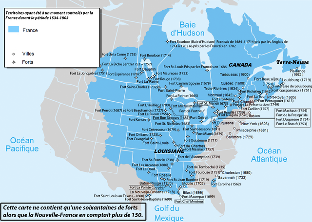
Français : Carte des territoires d'Amérique du Nord ayant été au moins une fois sous contrôle Français.
Français cadien : Carte des territoires combinés ayant été dans la nouvelle France de 1504 à 1803. |
| Date | |
| Source |
Own work Les Livres
avec le journal historique d'un voyage fait par ordre du roi dans l'Amérique septentrionnale (du 1er tome au 5eme)
Les Cartes
A new and accurate map of the English empire in North America; Representing their rightful claim as confirmed by charters and the formal surrender of their Indian friends; likewise the encroachments of the French, with the several forts they have unjustly erected therein.
Les Sites
|
| Author | Hypersite |
Licensing
[edit]
I, the copyright holder of this work, hereby publish it under the following license:
This file is licensed under the Creative Commons Attribution-Share Alike 3.0 Unported license.
- You are free:
- to share – to copy, distribute and transmit the work
- to remix – to adapt the work
- Under the following conditions:
- attribution – You must give appropriate credit, provide a link to the license, and indicate if changes were made. You may do so in any reasonable manner, but not in any way that suggests the licensor endorses you or your use.
- share alike – If you remix, transform, or build upon the material, you must distribute your contributions under the same or compatible license as the original.
File history
Click on a date/time to view the file as it appeared at that time.
| Date/Time | Thumbnail | Dimensions | User | Comment | |
|---|---|---|---|---|---|
| current | 00:23, 12 June 2012 | | 1,530 × 1,090 (1.38 MB) | Hypersite (talk | contribs) | Amélioration. |
| 00:18, 12 June 2012 |  | 1,530 × 1,090 (1.38 MB) | Hypersite (talk | contribs) | Erreur supprimé , sources ajoutées | |
| 00:14, 10 June 2012 |  | 1,530 × 1,090 (1.38 MB) | Hypersite (talk | contribs) |
You cannot overwrite this file.
File usage on Commons
There are no pages that use this file.
File usage on other wikis
The following other wikis use this file:
- Usage on es.wikipedia.org
- Usage on fr.wikipedia.org
- Usage on pl.wikipedia.org