File:Nouvelle-France map-es.svg
Jump to navigation
Jump to search

Size of this PNG preview of this SVG file: 800 × 570 pixels. Other resolutions: 320 × 228 pixels | 640 × 456 pixels | 1,024 × 730 pixels | 1,280 × 912 pixels | 2,560 × 1,824 pixels | 1,530 × 1,090 pixels.
Original file (SVG file, nominally 1,530 × 1,090 pixels, file size: 661 KB)
Captions
Captions
Add a one-line explanation of what this file represents
Summary
[edit]| Description |
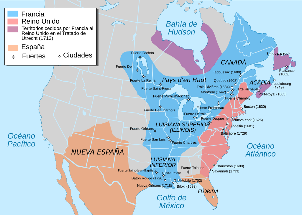
Català: Mapa de la Nova França sobre 1754-1755 English: Map of New France about 1750 using modern political boundaries Español: Mapa de la Nueva Francia cerca de 1750. Français : Carte de la Nouvelle-France vers 1754-1755 Norsk nynorsk: Kart over Ny Frankrike (ca 1754-1755) Русский: Карта Французских колоний в Америке 1750 中文(中国大陆): 1750年左右的新法兰西地图,附现代边界。 العربية : خريطة فرنسا الجديدة حوالي عام 1750 باستخدام الحدود السياسية الحديثة |
||
| Date | |||
| Source | Nouvelle-France map-en.svg | ||
| Author |
|
||
| Other versions |
[]
|


Licensing
[edit]
I, the copyright holder of this work, hereby publish it under the following license:
This file is licensed under the Creative Commons Attribution-Share Alike 4.0 International license.
- You are free:
- to share – to copy, distribute and transmit the work
- to remix – to adapt the work
- Under the following conditions:
- attribution – You must give appropriate credit, provide a link to the license, and indicate if changes were made. You may do so in any reasonable manner, but not in any way that suggests the licensor endorses you or your use.
- share alike – If you remix, transform, or build upon the material, you must distribute your contributions under the same or compatible license as the original.
File history
Click on a date/time to view the file as it appeared at that time.
| Date/Time | Thumbnail | Dimensions | User | Comment | |
|---|---|---|---|---|---|
| current | 16:15, 14 December 2022 | | 1,530 × 1,090 (661 KB) | Tcr25 (talk | contribs) | Fort Rosaile in wrong location; add Fort St-Jean-Baptiste |
| 08:41, 21 September 2019 |  | 1,530 × 1,090 (683 KB) | Rowanwindwhistler (talk | contribs) | fake text added | |
| 08:46, 17 December 2015 |  | 1,530 × 1,090 (305 KB) | Rowanwindwhistler (talk | contribs) | Larger fonts Coast | |
| 09:33, 9 August 2015 |  | 1,530 × 1,090 (234 KB) | Rowanwindwhistler (talk | contribs) | Towns in place now | |
| 09:25, 9 August 2015 |  | 1,530 × 1,090 (227 KB) | Rowanwindwhistler (talk | contribs) | User created page with UploadWizard |
You cannot overwrite this file.
File usage on Commons
The following 11 pages use this file:
- User:Magog the Ogre/Multilingual legend/2022 December 11-20
- File:Neufrankreich.svg
- File:Nouvelle-France map-ar.svg
- File:Nouvelle-France map-ca.svg
- File:Nouvelle-France map-en.svg
- File:Nouvelle-France map-es.svg
- File:Nouvelle-France map-fr.svg
- File:Nouvelle-France map-he.svg
- File:Nouvelle-France map-ru.svg
- File:Nouvelle-France map-zh-hans.svg
- Template:Other versions/Nouvelle-France map
File usage on other wikis
The following other wikis use this file:
- Usage on ast.wikipedia.org
- Usage on es.wikipedia.org