File:Northern central British Isles c 700.gif
Jump to navigation
Jump to search
Size of this preview: 697 × 599 pixels. Other resolutions: 279 × 240 pixels | 558 × 480 pixels | 979 × 842 pixels.
Original file (979 × 842 pixels, file size: 407 KB, MIME type: image/gif)
Captions
Captions
Add a one-line explanation of what this file represents
Summary
[edit]

|
This file was moved to Wikimedia Commons from en.wikipedia using a bot script. All source information is still present. It requires review. Additionally, there may be errors in any or all of the information fields; information on this file should not be considered reliable and the file should not be used until it has been reviewed and any needed corrections have been made. Once the review has been completed, this template should be removed. For details about this file, see below. Check now! |
| Description |
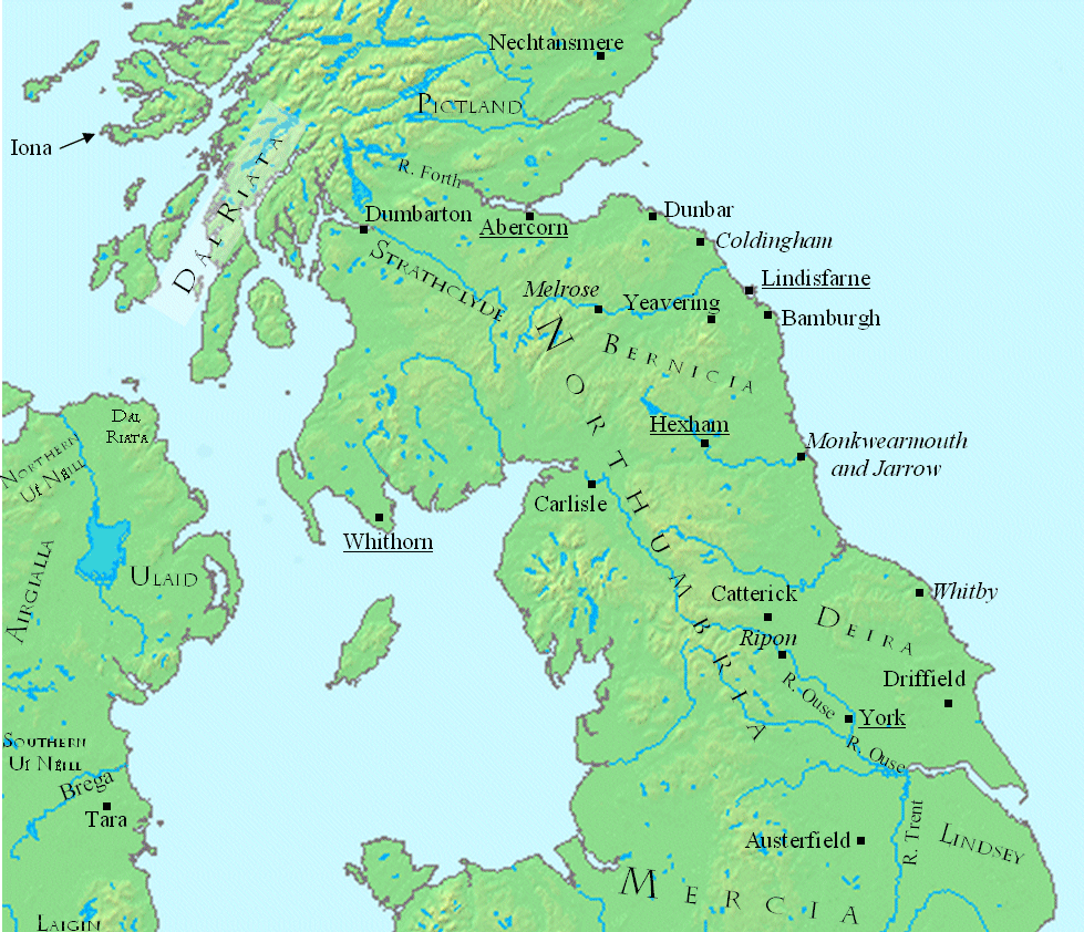
English: This is a map showing the north central British Isles in the late seventh century.
The file was created using DMIS. On that site it is stated that "We do not claim copyright on the images, so you can use them for Wikipedia." Sources include (for Great Britain) a map found in Peter Hunter Blair's "Roman Britain and Early England: 55 B.C.-871 A.D.", W.W. Norton, 1963, p. 209; and (for Ireland) on a map in Duffy's Atlas of Irish History. |
| Date | 10 February 2008 (original upload date) |
| Source | Transferred from en.wikipedia to Commons by CatMan61 using CommonsHelper. |
| Author | Mike Christie at English Wikipedia |
Licensing
[edit]
| This work has been released into the public domain by its author, Mike Christie at English Wikipedia. This applies worldwide. In some countries this may not be legally possible; if so: Mike Christie grants anyone the right to use this work for any purpose, without any conditions, unless such conditions are required by law. |
Original upload log
[edit]
The original description page was here. All following user names refer to en.wikipedia.
- 2008-02-10 22:41 Mike Christie 979×842× (416474 bytes) Move Strathclyde
- 2008-02-10 22:39 Mike Christie 979×843× (417411 bytes) Move Strathclyde further northeast
- 2008-02-10 20:43 Mike Christie 979×843× (418441 bytes) Move Strathclyde to the Clyde valley
- 2008-02-10 17:08 Mike Christie 981×842× (418505 bytes) Typo fix: Firth -> Forth
- 2008-02-10 16:44 Mike Christie 981×844× (419828 bytes) Move Strathclyde
- 2008-02-10 16:41 Mike Christie 979×843× (417131 bytes) Move Strathclyde a bit
- 2008-02-10 16:33 Mike Christie 980×843× (417179 bytes) Change Forfar -> Nechtansmere
- 2008-02-10 15:36 Mike Christie 980×842× (420235 bytes) This is a map showing the north central British Isles in the late seventh century. The file was created using [http://www.demis.nl/home/pages/home.htm DMIS]. On that site it is [http://support.demis.nl/forums/thread/1295.aspx stated] that "We do not cla
File history
Click on a date/time to view the file as it appeared at that time.
| Date/Time | Thumbnail | Dimensions | User | Comment | |
|---|---|---|---|---|---|
| current | 04:21, 3 January 2012 | | 979 × 842 (407 KB) | OgreBot (talk | contribs) | (BOT): Reverting to most recent version before archival |
| 04:21, 3 January 2012 |  | 979 × 843 (408 KB) | OgreBot (talk | contribs) | (BOT): Uploading old version of file from en.wikipedia; originally uploaded on 2008-02-10 22:39:02 by Mike Christie | |
| 04:21, 3 January 2012 |  | 979 × 843 (409 KB) | OgreBot (talk | contribs) | (BOT): Uploading old version of file from en.wikipedia; originally uploaded on 2008-02-10 20:43:53 by Mike Christie | |
| 04:20, 3 January 2012 |  | 981 × 842 (409 KB) | OgreBot (talk | contribs) | (BOT): Uploading old version of file from en.wikipedia; originally uploaded on 2008-02-10 17:08:54 by Mike Christie | |
| 04:20, 3 January 2012 |  | 981 × 844 (410 KB) | OgreBot (talk | contribs) | (BOT): Uploading old version of file from en.wikipedia; originally uploaded on 2008-02-10 16:44:14 by Mike Christie | |
| 04:20, 3 January 2012 |  | 979 × 843 (407 KB) | OgreBot (talk | contribs) | (BOT): Uploading old version of file from en.wikipedia; originally uploaded on 2008-02-10 16:41:23 by Mike Christie | |
| 04:20, 3 January 2012 |  | 980 × 843 (407 KB) | OgreBot (talk | contribs) | (BOT): Uploading old version of file from en.wikipedia; originally uploaded on 2008-02-10 16:33:49 by Mike Christie | |
| 04:20, 3 January 2012 |  | 980 × 842 (410 KB) | OgreBot (talk | contribs) | (BOT): Uploading old version of file from en.wikipedia; originally uploaded on 2008-02-10 15:36:41 by Mike Christie | |
| 13:19, 2 January 2012 |  | 979 × 842 (407 KB) | File Upload Bot (Magnus Manske) (talk | contribs) | {{BotMoveToCommons|en.wikipedia|year={{subst:CURRENTYEAR}}|month={{subst:CURRENTMONTHNAME}}|day={{subst:CURRENTDAY}}}} {{Information |Description={{en|This is a map showing the north central British Isles in the late seventh century. The file was create |
You cannot overwrite this file.
File usage on Commons
There are no pages that use this file.
File usage on other wikis
The following other wikis use this file:
- Usage on arz.wikipedia.org
- Usage on de.wikipedia.org
- Usage on el.wikipedia.org
- Usage on en.wikipedia.org
- Usage on fr.wikipedia.org
- Usage on it.wikipedia.org