File:North of east from Maes Knoll trigpoint - geograph.org.uk - 1389340.jpg
Jump to navigation
Jump to search
No higher resolution available.
North_of_east_from_Maes_Knoll_trigpoint_-_geograph.org.uk_-_1389340.jpg (640 × 469 pixels, file size: 135 KB, MIME type: image/jpeg)
Captions
Captions
Add a one-line explanation of what this file represents
Summary
[edit]| Description |
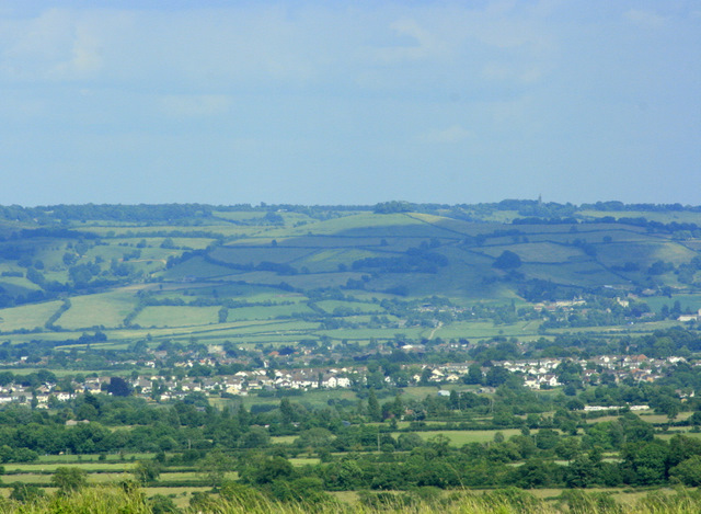
English: North of east from Maes Knoll trigpoint With a 200mm lens using the trig point as a tripod.
Beckford's Tower on Lansdown ST7367 is to the right on the skyline. Kelston Round Hill ST6771 is to the left of this just short of centre but is less easily seen. Kelston village is below Beckford's Tower, it is just possible to pick out the parish church. Moving closer spread across the screen we find Saltford. All we can see of Maes Hill is a fringe of long grass along the bottom edge. |
| Date | |
| Source | From geograph.org.uk |
| Author | Maurice Pullin |
| Camera location | | View this and other nearby images on: OpenStreetMap |
|---|
| Object location | | View this and other nearby images on: OpenStreetMap |
|---|
Licensing
[edit]
|
This image was taken from the Geograph project collection. See this photograph's page on the Geograph website for the photographer's contact details. The copyright on this image is owned by Maurice Pullin and is licensed for reuse under the Creative Commons Attribution-ShareAlike 2.0 license.
|
This file is licensed under the Creative Commons Attribution-Share Alike 2.0 Generic license.
Attribution: Maurice Pullin
- You are free:
- to share – to copy, distribute and transmit the work
- to remix – to adapt the work
- Under the following conditions:
- attribution – You must give appropriate credit, provide a link to the license, and indicate if changes were made. You may do so in any reasonable manner, but not in any way that suggests the licensor endorses you or your use.
- share alike – If you remix, transform, or build upon the material, you must distribute your contributions under the same or compatible license as the original.

_heading:67.00&language=en)
_heading:67.00&language=en)
File history
Click on a date/time to view the file as it appeared at that time.
| Date/Time | Thumbnail | Dimensions | User | Comment | |
|---|---|---|---|---|---|
| current | 19:07, 28 February 2011 | | 640 × 469 (135 KB) | GeographBot (talk | contribs) | == {{int:filedesc}} == {{Information |description={{en|1=North of east from Maes Knoll trigpoint With a 200mm lens using the trig point as a tripod. Beckford's Tower on Lansdown ST7367 is to the right on the skyline. Kelston Round Hill ST6771 is |
You cannot overwrite this file.
File usage on Commons
There are no pages that use this file.