File:North Warwickshire Line.png
Jump to navigation
Jump to search

Size of this preview: 424 × 600 pixels. Other resolutions: 169 × 240 pixels | 339 × 480 pixels | 543 × 768 pixels | 1,169 × 1,654 pixels.
Original file (1,169 × 1,654 pixels, file size: 76 KB, MIME type: image/png)
Captions
Captions
Add a one-line explanation of what this file represents
Summary
[edit]
| Description |
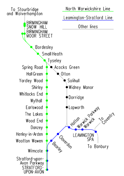
English: Diagrammatic map of the North Warwickshire and Leamington to Stratford lines; image created using MicroStation and exported as a png file. |
| Date | |
| Source | Own work |
| Author | Voice of Clam |

|
This transport map image could be re-created using vector graphics as an SVG file. This has several advantages; see Commons:Media for cleanup for more information. If an SVG form of this image is available, please upload it and afterwards replace this template with
{{vector version available|new image name}}.
It is recommended to name the SVG file “North Warwickshire Line.svg”—then the template Vector version available (or Vva) does not need the new image name parameter. |
Licensing
[edit]
| This work has been released into the public domain by its author, Voice of Clam. This applies worldwide. In some countries this may not be legally possible; if so: |
File history
Click on a date/time to view the file as it appeared at that time.
| Date/Time | Thumbnail | Dimensions | User | Comment | |
|---|---|---|---|---|---|
| current | 11:48, 8 October 2015 | | 1,169 × 1,654 (76 KB) | Voice of Clam (talk | contribs) | Original CAD file updated and exported as PNG |
| 13:58, 7 October 2015 |  | 1,093 × 1,599 (40 KB) | Pek the Penguin (talk | contribs) | Reverted to version as of 09:21, 25 March 2014 (UTC) | |
| 13:57, 7 October 2015 |  | 1,169 × 1,654 (45 KB) | Pek the Penguin (talk | contribs) | ||
| 09:21, 25 March 2014 |  | 1,093 × 1,599 (40 KB) | G-13114 (talk | contribs) | Further update. Moor Street connection is now open. | |
| 18:43, 4 October 2013 |  | 1,093 × 1,599 (41 KB) | G-13114 (talk | contribs) | Small adjustmants | |
| 05:16, 4 October 2013 |  | 1,093 × 1,599 (41 KB) | G-13114 (talk | contribs) | Updated to include Stratford Parkway | |
| 00:45, 5 December 2011 |  | 1,093 × 1,599 (80 KB) | File Upload Bot (Magnus Manske) (talk | contribs) | {{BotMoveToCommons|en.wikipedia|year={{subst:CURRENTYEAR}}|month={{subst:CURRENTMONTHNAME}}|day={{subst:CURRENTDAY}}}} {{Information |Description={{en|Diagrammatic map of the Birmingham to Stratford and [[:en:Leamingt |
You cannot overwrite this file.
File usage on Commons
The following 4 pages use this file:
File usage on other wikis
The following other wikis use this file:
- Usage on en.wikipedia.org
- Usage on es.wikipedia.org