File:North Nahanni River flows past the Battlement Range.jpg
Jump to navigation
Jump to search

Size of this preview: 800 × 531 pixels. Other resolutions: 320 × 212 pixels | 640 × 424 pixels | 1,024 × 679 pixels | 1,280 × 849 pixels | 1,544 × 1,024 pixels.
Original file (1,544 × 1,024 pixels, file size: 131 KB, MIME type: image/jpeg)
Captions
Captions
Add a one-line explanation of what this file represents
| Description |
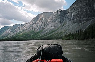
The following is the author's description of the photograph quoted directly from the photograph's Flickr page. "= Natural History = Best viewed large. After cutting straight through a thrust-faulted landform, the North Nahanni River turns 90 degrees and follows the aptly named Battlement Range. A thick section of limestone has been pushed up into the sky along with a veneer of 'skid-greasing' shale now draped like black curtains on the cliffs and scree slopes. A mid-river encounter with a lynx will soon take place. Watercraft is a 16 ft Coleman freighter canoe. This muddy river is often shallow enough to tap bottom with my paddle so I cannot make use of my small kicker until I reach the Mackenzie River. Zoom into flickr's dot on the map for this photo to see the braided channels of the North Nahanni River, Mackenzie Mountains, Northwest Territories, Canada. " |
||
| Date | |||
| Source |
originally posted to Flickr as Full Screen Plate Tectonics
|
||
| Author | Mike Beauregard | ||
| Permission (Reusing this file) |
This file is licensed under the Creative Commons Attribution 2.0 Generic license.
|
| Camera location | | View this and other nearby images on: OpenStreetMap |
|---|
File history
Click on a date/time to view the file as it appeared at that time.
| Date/Time | Thumbnail | Dimensions | User | Comment | |
|---|---|---|---|---|---|
| current | 15:16, 20 June 2010 | | 1,544 × 1,024 (131 KB) | Geo Swan (talk | contribs) | {{Information |Description=The following is the author's description of the photograph quoted directly from the photograph's Flickr page.<br/>"= Natural History = Best viewed large. <br>After cutting straight through a thrust-faulted landform, the North N |
You cannot overwrite this file.
File usage on Commons
The following 2 pages use this file:
.jpg&redirect=no)
File usage on other wikis
The following other wikis use this file:
- Usage on arz.wikipedia.org
- Usage on ceb.wikipedia.org
- Usage on de.wikipedia.org
- Usage on en.wikipedia.org
- Usage on id.wikipedia.org
- Usage on sv.wikipedia.org
- Usage on www.wikidata.org