File:North Australia Commission Map No. 6.jpg
Jump to navigation
Jump to search

Size of this preview: 762 × 600 pixels. Other resolutions: 305 × 240 pixels | 610 × 480 pixels | 976 × 768 pixels | 1,280 × 1,008 pixels | 2,560 × 2,015 pixels | 7,381 × 5,811 pixels.
Original file (7,381 × 5,811 pixels, file size: 5.58 MB, MIME type: image/jpeg)
Captions
Captions
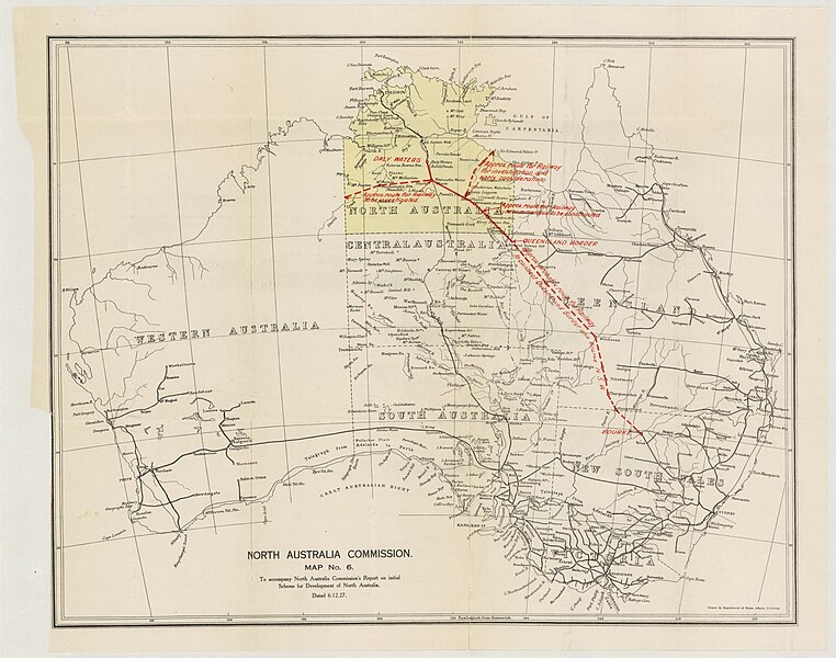
Map of proposed railway between New South Wales and the Northern Territory of Australia
Summary
[edit]
| Description |
English: Map of proposed railway line between Bourke, New South Wales and the Territory of North Australia |
| Date | |
| Source | State Library of South Australia |
| Author | North Australia Commission |
Licensing
[edit]
This image is protected by Crown Copyright because it is owned by the Australian Government or that of the states or territories, and is in the public domain because it was created or published prior to 1974 and the copyright has therefore expired. The government of Australia has declared that the expiration of Crown Copyrights applies worldwide. This has been confirmed by correspondence received by the Volunteer Response Team (Ticket:2017062010010417).
|
 |
File history
Click on a date/time to view the file as it appeared at that time.
| Date/Time | Thumbnail | Dimensions | User | Comment | |
|---|---|---|---|---|---|
| current | 01:36, 14 November 2023 | | 7,381 × 5,811 (5.58 MB) | ITBF (talk | contribs) | Uploaded a work by North Australia Commission from [https://digital.collections.slsa.sa.gov.au/nodes/view/2277 State Library of South Australia] with UploadWizard |
You cannot overwrite this file.
File usage on Commons
There are no pages that use this file.
File usage on other wikis
The following other wikis use this file:
- Usage on en.wikipedia.org