File:North Africa & Andalus map 800.png
Jump to navigation
Jump to search

Size of this preview: 800 × 565 pixels. Other resolutions: 320 × 226 pixels | 640 × 452 pixels | 1,024 × 723 pixels | 1,280 × 904 pixels | 1,530 × 1,080 pixels.
Original file (1,530 × 1,080 pixels, file size: 294 KB, MIME type: image/png)
Captions
Captions
Add a one-line explanation of what this file represents
Summary
[edit]
| Description |
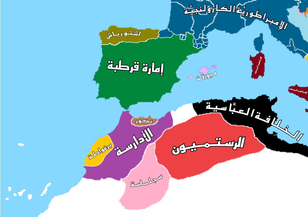
العربية: خريطة تظهر توزُّع الدُّول والممالك والإمارات في بلاد المغرب الأوسط والأقصى والأندلس والغال وما جاورهما في سنة 183 هـ / 800 م، وتظهر الخلافة العبَّاسيَّة والدولة الرُّستميَّة وسجلماسة والدولة الإدريسيَّة وبرغواطة ونكور وإمارة قرطبة الأمويَّة وأستورياس والإمبراطوريَّة الكارلونجيَّة أو الإفرنج وجزر ميورقة.
تم الاستناد على عدد من المراجع في توزيع القوى وأماكن السيطرة للدول والإمارات المذكورة وهُم: 1. كتاب الدولة العباسية، للمؤرخ محمد الخضري بك، طبعة مؤسسة المختار للنشر في القاهرة، صدر سنة 2003. 2. كتاب الكامل في التاريخ، للإمام ابن الأثير الجزري، طبعة بيت الأفكار الدولية في عمَّان، صدر سنة 2005. 3. مصادر مُتعددة من ويكيبيديا الإنجليزية والعربية حول كُل دولة وإمارة ومملكة في ذلك الوقت والمكان المذكورين. |
| Date | |
| Source | Own work |
| Author | BroXadal |
Licensing
[edit]
I, the copyright holder of this work, hereby publish it under the following license:
This file is licensed under the Creative Commons Attribution-Share Alike 4.0 International license.
- You are free:
- to share – to copy, distribute and transmit the work
- to remix – to adapt the work
- Under the following conditions:
- attribution – You must give appropriate credit, provide a link to the license, and indicate if changes were made. You may do so in any reasonable manner, but not in any way that suggests the licensor endorses you or your use.
- share alike – If you remix, transform, or build upon the material, you must distribute your contributions under the same or compatible license as the original.
File history
Click on a date/time to view the file as it appeared at that time.
| Date/Time | Thumbnail | Dimensions | User | Comment | |
|---|---|---|---|---|---|
| current | 06:08, 6 May 2024 | | 1,530 × 1,080 (294 KB) | أبو العباس (talk | contribs) | تغييرات حدودية |
| 13:50, 5 May 2024 |  | 1,530 × 1,080 (286 KB) | أبو العباس (talk | contribs) | تعديلات في منطقة وادي الشلف، وتامسنا، والبشكنج ومحيطها | |
| 15:14, 2 May 2024 |  | 1,530 × 1,080 (246 KB) | أبو العباس (talk | contribs) | Uploaded own work with UploadWizard |
You cannot overwrite this file.
File usage on Commons
The following 2 pages use this file:
File usage on other wikis
The following other wikis use this file:
- Usage on ar.wikipedia.org