File:Nordenskiold Glacier, Greenland ESA384377.jpg

Original file (1,920 × 1,080 pixels, file size: 2.99 MB, MIME type: image/jpeg)
Captions
Captions
Summary
[edit]| Description |
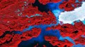
English: The Copernicus Sentinel-2A satellite takes us over the jagged islands along the west coast of Greenland in this false-colour image captured on 8 August 2017.
Covering more than 2 000 000 sq km, Greenland is the world’s largest island and home to the second largest ice sheet after Antarctica. But these ice sheets are sensitive to changes in our climate, and rising temperatures are causing them to melt faster. Scientists use Earth-observing satellites to track the ice loss. Between 2011 and 2014, Greenland lost around 1000 billion tonnes of ice. This corresponds to a 0.75 mm contribution to global sea-level rise each year. Melting ice sheets caused by rising temperatures and the subsequent rising of sea levels is a devastating consequence of climate change, especially for low-lying coastal areas. In addition, the increased influx of freshwater into oceans affects the salinity, which in turn affects global ocean currents – a major player in the regulation of our climate. On the right side of this image, the Nordenskiold Glacier is just one of many glaciers draining Greenland’s ice sheet. Vegetation appears red in this false-colour image, as the land here is covered by grasses and low-lying plants. Swirls of light blue in the water are suspended fine sediment produced by the abrasion of glaciers rubbing against rock, called ‘glacier milk’. This image is featured on theEarth from Space video programme. |
| Date | |
| Source | http://www.esa.int/spaceinimages/Images/2017/09/Nordenskiold_Glacier_Greenland |
| Author | European Space Agency |
| Permission (Reusing this file) |
contains modified Copernicus Sentinel data (2017), processed by ESA,CC BY-SA 3.0 IGO |
| Other versions |
|
| Title | Nordenskiold Glacier, Greenland |
| Set | Earth observation image of the week |
| System | Copernicus |
| Mission | Sentinel-2 |
| Location | Greenland |
| Activity | Observing the Earth |
| Keywords | Glaciers; Ice sheets; Satellite image |
Licensing
[edit]
- You are free:
- to share – to copy, distribute and transmit the work
- to remix – to adapt the work
- Under the following conditions:
- attribution – You must give appropriate credit, provide a link to the license, and indicate if changes were made. You may do so in any reasonable manner, but not in any way that suggests the licensor endorses you or your use.
- share alike – If you remix, transform, or build upon the material, you must distribute your contributions under the same or compatible license as the original.

|
This image contains data from a satellite in the Copernicus Programme, such as Sentinel-1, Sentinel-2 or Sentinel-3. Attribution is required when using this image.
Attribution: Contains modified Copernicus Sentinel data {{{year}}}
The use of Copernicus Sentinel Data is regulated under EU law (Commission Delegated Regulation (EU) No 1159/2013 and Regulation (EU) No 377/2014). Relevant excerpts:
Free access shall be given to GMES dedicated data [...] made available through GMES dissemination platforms [...].
Access to GMES dedicated data [...] shall be given for the purpose of the following use in so far as it is lawful:
GMES dedicated data [...] may be used worldwide without limitations in time.
GMES dedicated data and GMES service information are provided to users without any express or implied warranty, including as regards quality and suitability for any purpose. |
File history
Click on a date/time to view the file as it appeared at that time.
| Date/Time | Thumbnail | Dimensions | User | Comment | |
|---|---|---|---|---|---|
| current | 15:57, 29 September 2017 | | 1,920 × 1,080 (2.99 MB) | Fæ (talk | contribs) | European Space Agency, Id 384377, http://www.esa.int/spaceinimages/Images/2017/09/Nordenskiold_Glacier_Greenland, User:Fæ/Project_list/ESA |
You cannot overwrite this file.
File usage on Commons
The following 3 pages use this file:
.jpg&redirect=no)