File:NoordzeeScheepvaartroutes.png
Jump to navigation
Jump to search
Size of this preview: 800 × 565 pixels. Other resolutions: 320 × 226 pixels | 640 × 452 pixels.
Original file (850 × 600 pixels, file size: 24 KB, MIME type: image/png)
Captions
Captions
Add a one-line explanation of what this file represents

|
This transport map image could be re-created using vector graphics as an SVG file. This has several advantages; see Commons:Media for cleanup for more information. If an SVG form of this image is available, please upload it and afterwards replace this template with
{{vector version available|new image name}}.
It is recommended to name the SVG file “NoordzeeScheepvaartroutes.svg”—then the template Vector version available (or Vva) does not need the new image name parameter. |
Summary
[edit]
| Description |
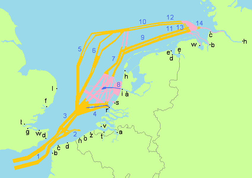
English: Map of the North Sea with roughly the current Traffic Separation Schemes
Nederlands: Kaart van de Noordzee met grofweg de huidige verkeersscheidingsstelsels |
| Date | |
| Source | Own work |
| Author | Romaine |
Licensing
[edit]
| This file is made available under the Creative Commons CC0 1.0 Universal Public Domain Dedication. | |
| The person who associated a work with this deed has dedicated the work to the public domain by waiving all of their rights to the work worldwide under copyright law, including all related and neighboring rights, to the extent allowed by law. You can copy, modify, distribute and perform the work, even for commercial purposes, all without asking permission.
|
| 1 | Straat van Dover | Strait of Dover |
| 2 | Westhinder-stelsel | Westhinder Traffic Separation Scheme |
| 3 | Noordhinder-stelsel | Noordhinder Traffic Separation Scheme |
| 4 | Eurogeul | Eurogeul and Traffic Separation Scheme |
| 8 | IJgeul | IJgeul and Traffic Separation Scheme |
| 9 | Terschelling-stelsel | Terschelling Traffic Separation Scheme |
| 10 | Oost Friesland-stelsel | Oost-Friesland Traffic Separation Scheme |
| 11 | Terschelling German Bight | Terschelling German Bight (Traffic Separation Scheme) |
| 12 | German Bight Western Approach | German Bight Western Approach (Traffic Separation Scheme) |
| 13 | Jade Approach | Jade Approach (Traffic Separation Scheme) |
| 14 | Elbe Approach | Elbe Approach (Traffic Separation Scheme) |
| Country | Harbours |
|---|---|
| Germany |
|
| Netherlands |
|
| Belgium |
|
| France |
|
| England |
|
File history
Click on a date/time to view the file as it appeared at that time.
| Date/Time | Thumbnail | Dimensions | User | Comment | |
|---|---|---|---|---|---|
| current | 19:54, 3 September 2022 | | 850 × 600 (24 KB) | Kontrollstellekundl (talk | contribs) | colours |
| 19:42, 3 September 2022 |  | 850 × 600 (24 KB) | Kontrollstellekundl (talk | contribs) | number + letter size doubled | |
| 15:51, 7 October 2009 |  | 864 × 642 (31 KB) | Romaine (talk | contribs) | 2x numbers added | |
| 09:36, 7 October 2009 |  | 864 × 642 (31 KB) | Romaine (talk | contribs) | {{Information |Description={{en|1=Map of the North Sea with the current Traffic Separation Schemes}} {{nl|1=Kaart van de Noordzee met de huidige verkeersscheidingsstelsels}} |Source={{own}} |Author=[[User:Romaine|Romaine |
You cannot overwrite this file.
File usage on Commons
The following page uses this file:
File usage on other wikis
The following other wikis use this file:
- Usage on de.wikipedia.org
- Usage on fr.wikipedia.org
- Usage on nl.wikipedia.org